All Activity
- Past hour
-
Similar here. 3" of frozen crust. At least it's still white.
-
@Chris78 Just got to Deep Creek…when we drove past Wisp, guns were blazing all over the mountain.
-

Minor snowfall sunday 12/14/25 1-4” possible
SnoSki14 replied to WeatherGeek2025's topic in New York City Metro
I like 2-4" from this. Advisory is right on the money. Agree about the ratios. Some localized spots will definitely see 4"+ -

Minor snowfall sunday 12/14/25 1-4” possible
WestBabylonWeather replied to WeatherGeek2025's topic in New York City Metro
We were spoiled with all the bombs we got not too long ago. Back to reality. I’ll take the 4” -
I want this to happen with my soul, but damn, you don’t get much more hopium than an operational run at hour 316 on the 18z GFS. Lol
-
That’s a 5 day mean so there’s a really cold airmass in there once you subtract the 60° on Christmas out.
-

Central PA Winter 25/26 Discussion and Obs
Ruin replied to MAG5035's topic in Upstate New York/Pennsylvania
Yeah even of its that -
Well two houses up in your neighborhood unless you’re shut ins you should have some kind of relationship and have checked in
-
I’ve never met them. I heard they have family they’re staying with. But here’s a
-

Minor snowfall sunday 12/14/25 1-4” possible
MJO812 replied to WeatherGeek2025's topic in New York City Metro
Its december -

December 14th - Snow showers or Plowable snow?
ORH_wxman replied to Sey-Mour Snow's topic in New England
18z euro brought the lighter QPF a bit north but trimmed back slightly south coast and Cape. Mostly just noise though. -
You took them in right?
-

Richmond Metro/Hampton Roads Area Discussion
Conway7305 replied to RIC Airport's topic in Mid Atlantic
Wouldn’t this be nice for Christmas Day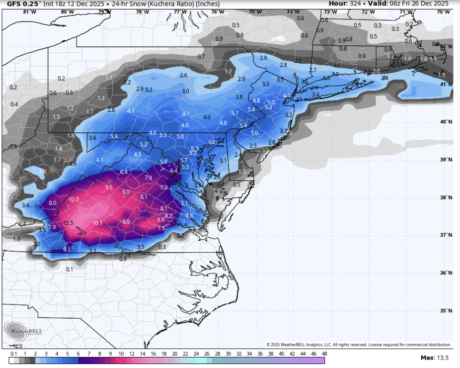
-

December 14th - Snow showers or Plowable snow?
Baroclinic Zone replied to Sey-Mour Snow's topic in New England
Nice to miss 2 cycles of model runs to come back and see things are still on track. Still possible thing break either way but looks good for where I’m at. -
Oh man if only the Christmas Miracle from the 18z GFS came true.
-

Minor snowfall sunday 12/14/25 1-4” possible
nightknights replied to WeatherGeek2025's topic in New York City Metro
Sad times getting Frosty Boners over a few inches. I long for the Bombs like we used to get -
Always hated hearing news of fires just prior to the holiday.
-
Minor snowfall sunday 12/14/25 1-4” possible
MJO812 replied to WeatherGeek2025's topic in New York City Metro
Sref -
Told you. I drink beer and know things. Won’t be there later but damn what a view.
-
if you're on safari, make sure to request desktop website to access it.
-
Have about 3-4" of leftover arctic crust here. Should add 1/3-2/3" of pixies to it tomorrow.
-
My man Ed making an appearance. Been quite some time since we last saw each other.
-

December 2025 Short/Medium Range Forecast Thread
jaxjagman replied to John1122's topic in Tennessee Valley
URGENT - WEATHER MESSAGE National Weather Service Nashville TN 607 PM CST Fri Dec 12 2025 TNZ005>011-023>034-056>066-075-077>080-093>095-130700- /O.NEW.KOHX.CW.Y.0005.251214T0600Z-251214T1800Z/ Stewart-Montgomery-Robertson-Sumner-Macon-Clay-Pickett-Houston- Humphreys-Dickson-Cheatham-Davidson-Wilson-Trousdale-Smith- Jackson-Putnam-Overton-Fentress-Perry-Hickman-Lewis-Williamson- Maury-Marshall-Rutherford-Cannon-De Kalb-White-Cumberland-Bedford- Coffee-Warren-Grundy-Van Buren-Wayne-Lawrence-Giles- Including the cities of Woodbury, Mount Juliet, Crossville, Manchester, Linden, Dickson, Kingston Springs, Lobelville, Allardt, Dover, Franklin, Springfield, Smyrna, South Carthage, McEwen, Centerville, Carthage, Celina, Cookeville, Pulaski, Clarksville, Waverly, Columbia, Clifton, Tullahoma, Coalmont, Gainesboro, New Johnsonville, Lafayette, Tennessee Ridge, Smithville, Altamont, Ashland City, Gordonsville, McMinnville, Lebanon, Nashville, Gallatin, Shelbyville, Brentwood, Lewisburg, Spencer, Sparta, Livingston, Erin, Byrdstown, La Vergne, Hartsville, Waynesboro, Goodlettsville, Hendersonville, Lawrenceburg, Murfreesboro, Jamestown, and Hohenwald 607 PM CST Fri Dec 12 2025 ...COLD WEATHER ADVISORY IN EFFECT FROM MIDNIGHT SATURDAY NIGHT TO NOON CST SUNDAY... * WHAT...Very cold wind chills as low as 1 below expected. * WHERE...A portion of Middle Tennessee. * WHEN...From midnight Saturday Night to noon CST Sunday. * IMPACTS...Wind chill values can lead to hypothermia with prolonged exposure. -
No Roxboro jackpot, toss it out
-
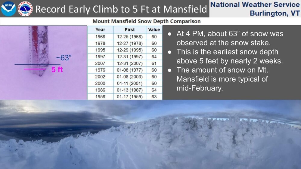
Mansfield stake goes over 5 feet and beats the previous earliest 60”+ depth by two weeks. Skiing is all-time, just like the depths.