All Activity
- Past hour
-

Richmond Metro/Hampton Roads Area Discussion
wasnow215 replied to RIC Airport's topic in Mid Atlantic
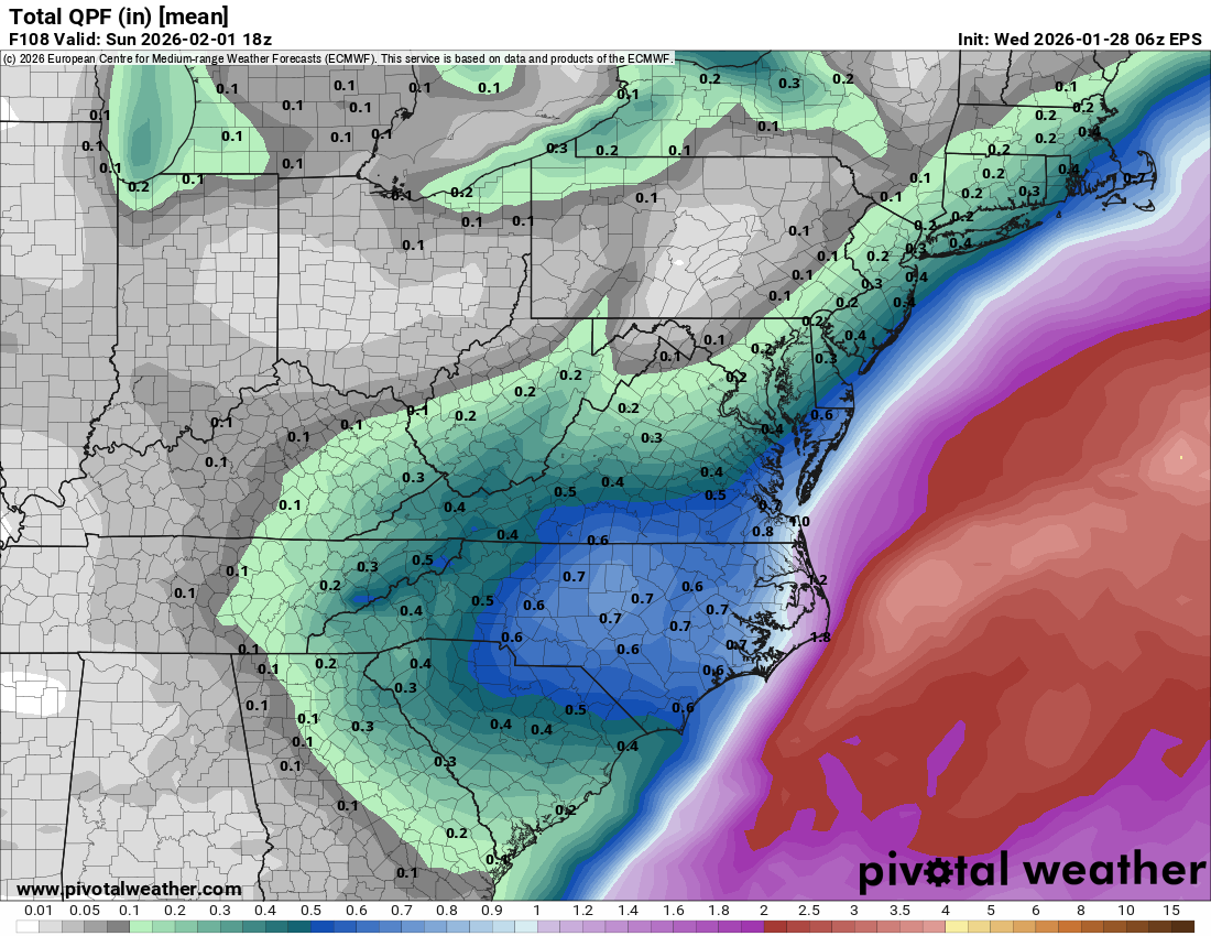
6Z European model is a little better than 0Z. I still like our chances for a SECS -

The “I bring the mojo” Jan 30-Feb 1 potential winter storm
olafminesaw replied to lilj4425's topic in Southeastern States
0z vs 6z EPS is a nice uptrend
-
Nam 3km says this starts for the high elevations Friday around noon. This one could really slip up on us here with all the angst about missing snow last weekend and the negative attitude towards forecasting that many currently have.
-

Possible coastal storm centered on Feb 1 2026.
dendrite replied to Typhoon Tip's topic in New England
All of the runs of all of the models are essentially the same thing. -

The Jan 31 Potential: Stormtracker Failure or 'Tracker Trouncing
baltosquid replied to stormtracker's topic in Mid Atlantic
Also FWIW on both the EPS and EPS-AIFS the possible kicker looks to be a bit slower than 00z -
Richmond Metro/Hampton Roads Area Discussion
wasnow215 replied to RIC Airport's topic in Mid Atlantic
You actually taught me to be more thankful for the snow we get. I walked my dogs yesterday and I felt like it was from the movie the day after tomorrow I was just walking on top of the snow because it was all frozen lol. We've gone years without any accumulating snow and it hasn't been that long to go a few years ago we went but five or six years? I'm so thankful for the snow cover we have right now and I'm pretty sure we're gonna get anywhere between 3 to 6 inches of these this weekend especially with rates -
 It’s pretty clear to me it’s gonna get kicked east - just based on weight of the modeling - weenie hope is that kicker isn’t modeled correctly due to lack of sampling lol- I’ve been on this board well longer than a bunch of the newer posters have been alive and I know what it means when we arrive at that scrap of hope…
 -
U were 14f colder! 6 for a low here
-
5.7 in Stephenson Virginia
-

The “I bring the mojo” Jan 30-Feb 1 potential winter storm
eyewall replied to lilj4425's topic in Southeastern States
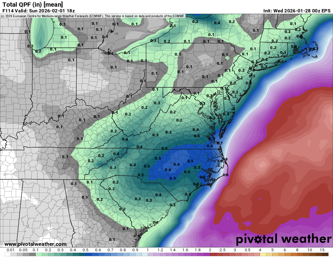
At the surface, cyclogenesis appears likely just off the Southeast coast, where a weaker but still prevalent baroclinic zone is forecast over the Gulf Stream. The primary front is expected to be still draped across the Bahamas, setting up a probable instant occlusion low surface pattern. The low off the Carolina coast is expected to rapidly deepen Sat into Sat night, as stronger synoptic ascent overspreads the Gulf stream and the main synoptic front is pulled northward. On the backside of the low, an Arctic airmass will become locked in over the Mid-Atlantic as the low deepens off the coast, resulting in potentially record breaking low max temperatures during the event. This pattern is favorable for at least light snow with a high snow/liquid ratio within central NC, but also brings an incredibly difficult forecast challenge related to a deformation band on the north and west side of the deepening low. The likelihood of band formation, let alone its timing and placement, remains a point of considerable uncertainty and may not be ironed out until 1-2 days before the event begins. However, the top analogs and latest suite of 00z model guidance highlights at least the potential for significant snowfall totals somewhere from the Carolinas into the Mid-Atlantic. There are a few failure modes for this setup which would result in less precipitation over central NC. The first is the placement and the latitude the mid/upper level low closes; minor adjustments will have potentially significant ramifications on if/when/where the deformation band sets up. The second is that some degree of cyclogenesis will occur along the primary baroclinic zone over the Bahamas and may draw stronger ascent, moisture, and related liquid equivalent and snow amounts away from the instant occlusion-type, nearer-shore coastal low. -
The Jan 31 Potential: Stormtracker Failure or 'Tracker Trouncing
baltosquid replied to stormtracker's topic in Mid Atlantic
EPS looks a bit better. Members getting closer. -

Possible coastal storm centered on Feb 1 2026.
mahk_webstah replied to Typhoon Tip's topic in New England
-

Possible coastal storm centered on Feb 1 2026.
WinterWolf replied to Typhoon Tip's topic in New England
You sure did you meatball…you said this was gone Sunday…so stop. Youve been struggling big time. Everything is gone with you. Scooter doesn’t know! This isn’t gone. And you’re in the best spot at the moment. But a subtle change puts everybody in the game. So stop your nonsense. -

Possible coastal storm centered on Feb 1 2026.
Sey-Mour Snow replied to Typhoon Tip's topic in New England
Ya just less so, speaking of that - the EURO just 100 miles NW would be 15-30" region wide lol . and we still have 96 hours to go -

January 2026 regional war/obs/disco thread
NW_of_GYX replied to Baroclinic Zone's topic in New England
Cold morning, -13f -

The Jan 31 Potential: Stormtracker Failure or 'Tracker Trouncing
mitchnick replied to stormtracker's topic in Mid Atlantic
Fwiw, if you compare 0z Nam to 6z, you can see that it took has taken on the precip shield as Gfs and Euro at 84hrs vs the "headed north" look of 0z. -
I’d want to see a positive trend by tonight 0z to be confident of a major hit here. Good that with even a track SE of the benchmark some snow makes it to the coast/city as it unravels. As others mention this has to occlude later and upper low track further north.
-
10 degrees here in fallston - same as this time yesterday.
-

The Jan 31 Potential: Stormtracker Failure or 'Tracker Trouncing
aldie 22 replied to stormtracker's topic in Mid Atlantic
I mean its a lot heavier lift to get that thing back here to me than you. I'd almost feel good if I was in your spot -

Arctic Hounds Unleashed: Long Duration Late January Cold Snap
wx2fish replied to WxWatcher007's topic in New England
@CoastalWx approved fake cold this morning. Wild differences over short distances. -
Possible coastal storm centered on Feb 1 2026.
WinterWolf replied to Typhoon Tip's topic in New England
You didn’t like the last one either…until it kept trending every run north at this time last week. -

The Jan 31 Potential: Stormtracker Failure or 'Tracker Trouncing
SBYWeather replied to stormtracker's topic in Mid Atlantic
That would be ideal, but honestly with the setup it seems like it would act as a kicker and no real shot of phasing at this time. Still something to watch for though as we have some time. -

Possible coastal storm centered on Feb 1 2026.
CoastalWx replied to Typhoon Tip's topic in New England
See above you meatballs -
 -4 here. Deep winter.