All Activity
- Past hour
-
48.2 glorious degrees this morning! Was a chilly and delightful walk!
-
Please, please let it be nice when I get home. 2 weeks of ridiculous heat (I mean, I asked for it by choosing to come down here in August) and now I'm ready for a break from this. We've been to the Everglades, Miami and the keys. The Overseas Highway did not disappoint. Quite a contrast from Mammoth Lakes but I've enjoyed them both equally. Heading north tomorrow.
-
 Just move down to the city. I don't know what all the ruckus about cold is about, we didn't drop below 60 here in the city. We probably won't get our first frost until December either lol
 -
UHI keeping me toasty here. Didn't even drop below 60 I think. Fall in the city is always delayed by a solid month due to pesky concrete.
-
Low of 47. Coolest so far this week.
-
I'm split on that. Do we need crazy cold source regions? Probably for sustained retro cold. Doubtful for quick intense shots like we get. Long as the AO flips cold will get delivered somewhere in the mid-latitudes. Other teleconnections help forecast exactly where, but as we've discussed it gets nebulous in the last decade or two. One thing to note is a marine heat wave across much of the northern Pacific Ocean. Parts of the Atlantic are similar. Mercifully it's not all in the Tropical Atlantic. Some hypothesize, and after some success we could say theorize, warmer oceans up north create conditions favorable for blocking. I'm talking general blocking -AO not necessarily cold air destination. So while warm oceans could promote a mild fall, warm SSTs could also set up some winter blocking. Current situation is an example of how it can be warmer than normal in Western Canada, while the Southeast is cool. Well that's an old teleconnection too, but for sustained cold the source does need to reload.
-
I don't think it will be a ratter, but there are some limitations.
-
Hit 43 IMBY. Now if we could only get some decent rain. Got about 12 drops yesterday from some random popcorn cloud.
-

2025-2026 ENSO
40/70 Benchmark replied to 40/70 Benchmark's topic in Weather Forecasting and Discussion
I agree with this...I'm not arguing that there isn't utility in seasonal rankings....however, if you aren't forecasting for a client that requests that and understand the context of currently climo within a warming client than it isn't necessary. I do incorporate use of the 1951-2010 climo period for temps in an effort to "normalize" some of that disparity owed to CC when using analogs...otherwise, most older analogs will appear frigid by today's standards. -
You could almost sail from Africa to Florida without seeing a single cloud
-
 not super stoked on the temps, i do love me some summer heat. heading out to san diego in a week to grasp my last bit of summer. one good thing, i assume these low temps early in the season will bode well for some vibrant fall colors in a month and a half or so
 -
54 was the low here. Onward nice weather!
-
i would have taken this in July when i was at the beach. Instead of it being hotter then a witches tit in a brass bra
-
Bone dry in my section of Brooklyn, missed out on your shower yesterday; let’s see what the next week brings
-
Last year I had 52 inches ytd this year 30.
-
Though yesterday’s full daily average sunspot # didn’t come close to the 290 record high for the current cycle, it still was a very impressive 207 and today’s early avg is at 209: 2025 08 22 2025.640 57 8.7 25 27 2025 08 23 2025.642 75 7.0 23 28 2025 08 24 2025.645 110 8.2 31 38 2025 08 25 2025.648 139 15.2 35 42 2025 08 26 2025.651 191 21.2 30 34 2025 08 27 2025.653 207 17.2 20 28 2025 08 28 2025.656 209 15.8 10 12 @snowman19
-
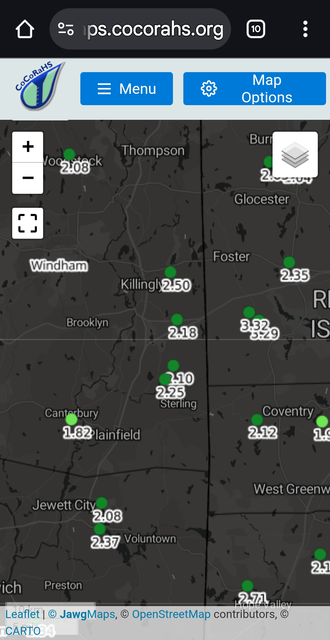
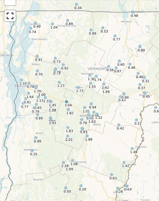
Here’s our MTD up here… Find @J.Spin’s relatively drought-proof spot along the Spine/Winnoski Gap in the precip magnet. Joking aside, there are a bunch of PWS in the area over 2.5”+ the closer you get to the Spine. My local spot is 2.51” on the month. @dmcginvt is at 2.83” in Waterbury Center (assuming that’s his site given the PWS is the same name as his handle here). The wild sites are the under 1” up next to Jay Peak.
-
Too bad we couldn't get a storm off the coast late next week with that southerly flow in place for a few days.
-

September 2025 OBS-Discussion centered NYC subforum
MANDA replied to wdrag's topic in New York City Metro
High amplitude troughing near and west of 80W.....I'll take it! Please! Would be nice to have something in the tropics to take advantage of that position but nothing in the pipeline. Hoping for something meaningful. In the meantime August looks to finish with nothing and be a very dry month overall. -
Sick maple color season's begun around northern Middlesex CO
-
 52. What month is it?
 -
 47.5 here. First 40s. Trenton was 49, first August 40s since 2000
 -
Gotta say that seeing the 540 line dig into the lakes states already on models for next week has me excited for fall
-
MTD 7.05 for the summer last year 18.25

- Today
-
A cool August is a blessing. I do understand why some dont like it if they are beach goers. It isnt quite the best beach weather.