All Activity
- Past hour
-
Agreed. I'm stopping short of asking that myself, just because there's too much subjectivity to what summer "should be" to really wanna even engage in that futile endeavor, but personally? I think next week is 'seasonally bn' The thing is, it's like there's multiple aspects concurrently true. The pattern verifies as a below normal +PNAP structure more than less, but we end up warmer than the pattern suggests we should - while still being lower that summers have been on sunny days going back 20 years worth of Gretta's ovulation cycles.
-

2026-2027 Super El Nino
snowman19 replied to Stormchaserchuck1's topic in Weather Forecasting and Discussion
I wonder what the models will show once this current WWB and the new DWKW that has formed does their “dirty work”? -
That dude was embedded within the line with 70-75 MPH straight line winds around it. Substantial damage caused by falling trees in Huntington, as well as the town of Andrews and Wabash, which are all located along US 24, basically the path that the radar indicated tornado took, from the town of Wabash to Ft. Wayne. I couldn't see anything from my house and wasn't going chase blind, but from radio traffic last night, if there was one on the ground, it went just north of town. NWS will be here this afternoon.
-
Records: Highs: EWR: 97 (2017) NYC: 93 (2017) LGA: 96 (2017) JFK: 92 (2017) Lows: EWR: 47 (1951) NYC: 48 (1979) LGA: 49 (1979) JFK: 49 (1980) Historical: 1881 - Severe thunderstorms spawned more than half a dozen tornadoes in the Lower Missouri Valley. Five of the tornadoes touched down near Saint Joseph MO. In south central Kansas a tornado nearly wiped out the town of Floral. Hail and high winds struck Iowa and southern Minnesota. In Minnesota, Blue Earth City reported five inches of rain in one hour. (David Ludlum) 1885: A tornado in Iowa blew part of a train off the tracks, injuring three passengers. Three coaches and a baggage car were lifted into the air and onto a field. (Ref. Wilson Wx. History) 1899: New Richmond, Wisconsin: A killer tornado rampages through New Richmond, Wisconsin, 114 people die, many attending an outdoor circus. 1915: An estimated F4 tornado moved northeast from northwest of Waterville, Iowa crossing the Mississippi River two miles south of Ferryville, Wisconsin. A man and his daughter were killed in one of three homes that were obliterated southwest of "Heytman," a small railroad station on the Mississippi River. 60 buildings and eight homes were destroyed in Wisconsin. This tornado caused approximately $200,000 in damage. In addition to this tornado, another estimated F4 tornado moved northeast across Fayette and Clayton Counties in northeast Iowa. One farm was devastated, the house and barn leveled. Heavy machinery was thrown 300 yards. Clothing was carried two miles. 1918: Victorville, CA recorded their highest temperature for June at 114°. This was also their second highest temperature ever (116° - 7/10/2002). This was followed be their warmest night on record with a low of 88°. (Ref. Wilson Wx. History) 1947 - A heavy wet snow blanketed much of southern and central Wyoming, and gave many places their heaviest and latest snow of record. Totals included 18.4 inches at Lander, 8.7 inches at Cheyenne, and 4.5 inches at Casper. (11th-12th) (The Weather Channel) 1948: The Columbia River Basin flood peaked on this date in the Northwest. The flood produced the highest water level in the basin since the flood there in 1894. The damage estimate for the 1948 flood was $101 million, and 75 lives were lost. 1956: The upper Midwest was in the midst of a six-day stretch of 90 degree plus temperatures. The high of 97° at Chicago, IL and 95° at Rockford, IL set daily high temperature records. (Ref. Wilson Wx. History) 1959: A heavy thunderstorm was accompanied by a small tornado at Celeron near Jamestown, NY and gave a two inch rainfall in 75 minutes in Colden, NY. (Ref. Wilson Wx. History) 1968: Tropical Storm Abby moved northeast and crossed central Florida, briefly reaching hurricane status in the Gulf of Mexico. The tropical storm then moved along the coast of Florida and into Georgia, then made a loop as a tropical depression through the Carolinas, moving south to the North Carolina/South Carolina coast. Locations that received record daily rainfalls included: Philadelphia, PA: 3.05 inches, Reagan National Airport in Washington, DC : 2.23 inches, Dulles Airport at Sterling, VA: 1.88 inches, Wilmington, DE: 1.75 inches, Newark, NJ: 1.74 inches and Williamsport, PA: 1.30 inches. (Ref. Wilson Wx. History) 1969 - Record late season snows covered parts of Montana. Five inches was reported at Great Falls and east of Broadus. Billings, MT, tied their June record with lows of 32 degrees on the 12th and the 13th. (The Weather Channel) 1978: Lightning killed a 14 year old boy running home to avoid the rain at Lauderhill, FL. The lightning struck a pine tree near the boy and severely burned his legs and knocked his shoes off. (Ref. Wilson Wx. History) 1983 - The state of Utah was beseiged by floods and mudslides. Streets in downtown Salt Lake City were sandbagged and turned into rivers of relief. The town of Thistle was completely inundated as a mudslide made a natural dam. (The Weather Channel) 1987 - Thunderstorms in Nebraska produced softball size hail around Fremont and Ames, and 3.5 inches of rain in less than one hour. Four and a half inches in less than an hour caused flooding around Ithica, NE. A tornado destroyed a mobile home near Broken Bow, NE, injuring both occupants. (The National Weather Summary) (Storm Data) 1988 - Fifteen cities in the southeastern U.S. reported record low temperatures for the date, including Asheville with a reading of 40 degrees. Drought conditions continued to intensify across the eastern half of the nation. Rainfall at Nashville, TN, was running 12.5 inches below normal. (The National Weather Summary) 1989 - Thunderstorms produced severe weather from Tennessee Valley to the Central Appalachians in the afternoon and evening, and produced severe weather in Oklahoma and Texas during the evening and night. Thunderstorms spawned ten tornadoes, and there were 164 reports of large hail and damaging winds. Thunderstorms produced wind gusts to 100 mph at Amarillo, TX, and wind gusts to 110 mph at Denton TX. Hail three inches in diameter was reported at Tucumcari NM. (The National Weather Summary) (Storm Data) 1994: Dickinson County was hard hit when 60 to 80 mph winds struck throwing a sail boat into a tree along the Spirit Lake shoreline. Reports from around Emmet, Dickinson and Clay Counties indicated rainfall amounts from 2 to as much as 6 inches within a two hour period. Flash flooding was also reported in Lyon County where an incredible three inches of rain fell in a 30 minute period in the town of George. A tornado formed in Plymouth County and moved through the town of Le Mars, causing about $3 million dollars in damage. Approximately 120 buildings were damaged with 2 x 6 boards driven through neighboring houses. The tornado picked up a dog house with the dog still inside. The dog house was deposited a few blocks away, upside down, with the dog still inside. The dog was not injured. Hail destroyed 70,000 acres of cropland across South Dakota. In Hand County, South Dakota, a thunderstorm caused an estimated $3 million dollars in crop damage. Hail, the largest being baseball size, was reported in drifts of three to four feet high. About 70 thousand acres of cropland and pastures were completely destroyed. Pheasants and ducks were killed by the hail and many cattle injured. Many windows were broken in homes, holes were punched in mobile homes, damaged occurred to contents of homes from hail which entered through windows, and many vehicles were extensively damaged. (Ref. Wilson Wx. History) 2002: (Kearney, Nebraska area): Hailstorm caused $2 million in agricultural losses. More than 22,000 acres of corn, soybeans and alfalfa were severely damaged or destroyed. (Ref. Hail Events by Michael Mogil) A supercell thunderstorm dumped copious amount of large hail across Buffalo and Kearney Counties in Nebraska. Hail up to 5 inches in diameter fell, injuring 15 people, and doing $100 million in damages. In excess of 6,000 structures sustained damage. In some cases, hailstones penetrated shingles, sheeting, and interior ceiling drywall. One person reported an 8 inch diameter hole in their roof. Another person reported hailstones landing on the living room couch after falling through the roof.(Ref. Wilson Wx. History) 2005 - A tornado in Hammond, Wisconsin damaged 22 homes and produced $3.6 million in damage (Associated Press).
-
Oh I'm sure it's in the mail. Probably what happens is you'll get that population overtaxing and die off around your region over the next month. Things get better into July while we "wake" up down here. Just delayed. There's always at least 2 or 3 week window where if seems like we left open all the windows, just a matter of when.
-
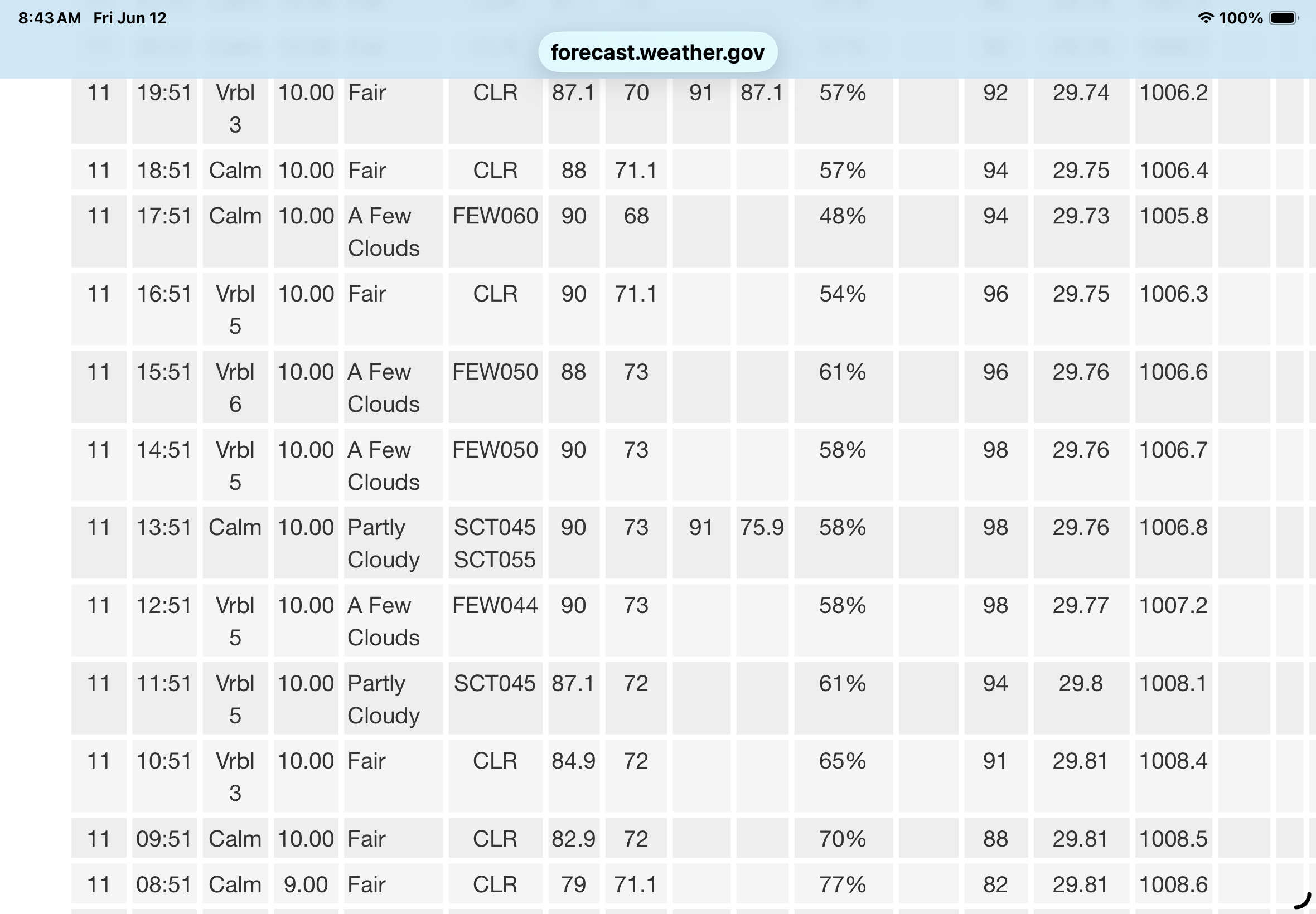
79 / 71 partly cloudy here a bit more cloudy north. Hay - Hot - humid low - mid/upper 90s tody. More storm chances. A bit drier / cooler Sat / Sun upper 80s to low/mid 90s i the hottest locations. 6/15 - 6/17 cooler, warm back up by the 18th and overall warmer beyond there by way of mix of some near normal - below and shorter intervals of heat. Ahead of next month next heat surge.
-
Ah,... yeah, I guess. I typically just use temperature. DP around here - for me - is always iffy. Seems odd maybe to think that with an actual ocean sitting there, but we are the confluence of a dry and wet stream. It seems we spend about equal time either in a continental arid Canadian delivery ( even over the top heat is sometimes coughing dry), or... we get a mash up of Dallas to Chicago industrial flatulence mixed with southern bio-mist. Every once in a rarer while we'll get a real pure DP air via the Bahama transport - some of the bluest sky on the planet actually occurs when the DP is 78 F that way.
-

2026 Mid-Atlantic Severe Storm General Discussion
batmanbrad replied to Kmlwx's topic in Mid Atlantic
SPC did keep the 30 wind area in their 9AM update, but did shift it a bit E/SE, otherwise few changes - as you say, we'll see if anything improves on the CAMs otherwise many of us may (again) be disappointed. -
Except I’m at stupid IAD
-
The last 5 days have been insane here. You literally can’t stop moving. It’s like living in the Amazon.
-
Good morning BW. Sadly and I mean this for city residents only. Central Park, at least, in the warm season is not a typical indicator of what our five Borough folks are experiencing, temperature wise. Newark and our airports set records and yet our official high temperature is 91. The dryness concerns me as I believe we are near six inches below yearly average rainfall to date for the city. Stay well, as always ….

-
MEX is like 75-80 for everyone CON-south next week. I don’t understand the fretting over that. Yeah we lose the dews and rad spots will have 45-50 nights, but it doesn’t look dire? Beyond d7 I really don’t care what they spew out so INS can post his 300hr 3C 850 maps and I’ll print them and use them for TP.
-
Looks like lower dews tomorrow. I jsut mean a true soupy summer morning.
-
Last night I did a 5 minute post dinner stroll to try and get ahead of insulin resistance ... and that was about 15 min after sunset in the still warm/sultry evening air. I came to halt and stood their in the dead quite and did not hear one ear whir, and did not feel a single insect land on the legs. I don't know what's going on... we don't seem to have any squiter's down this way.
-
Supposed to be 90 tomorrow and Sun on the same MOS I just impugned haha. Hey, it is what it is. If that's the case, you probably have until that front comes through overnight into Monday morning. Next week looks like a "seasonally BNer" - ie, not ridic just cooler than it should be for the fact that this is going on at the same time... (the brown line is the world ... buckin' for warmest ever against 2024 and 2023 as we speak) Sometimes I think SE Can/NE U.S. are not part of Earth Anyway, despite that weird intention by Gaia to bull's eye New England for enabling deniers, if not hiding CC from Washington D.C. policy makers altogether, ... the actual thickness in that pattern are not appreciably cold. Clears out with WNW breeze in 558 dm -type thickness and it's upper 70s. So there's a sneaky sort of aspect in that, too -
-
It’s soupy enough I think the mosquitoes are breeding in midair.
-
Now this is a summer morning despite the clouds. Too bad this is it for awhile.
-

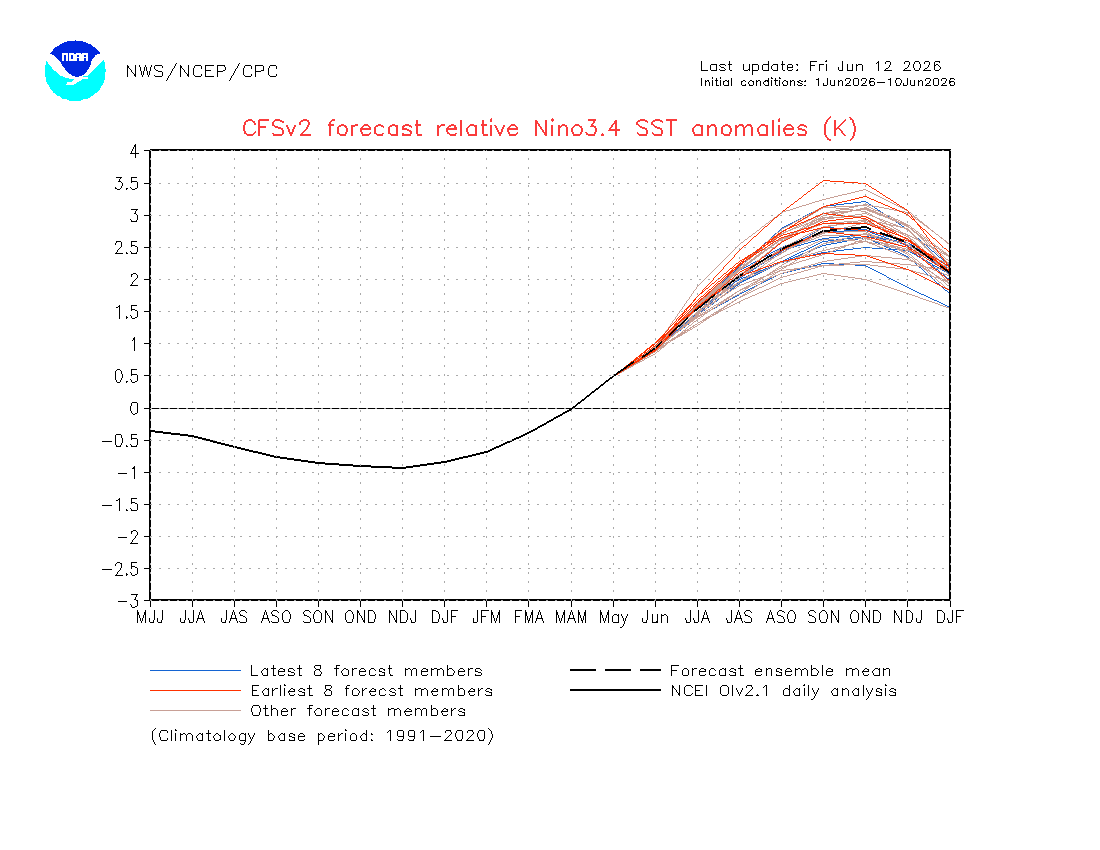
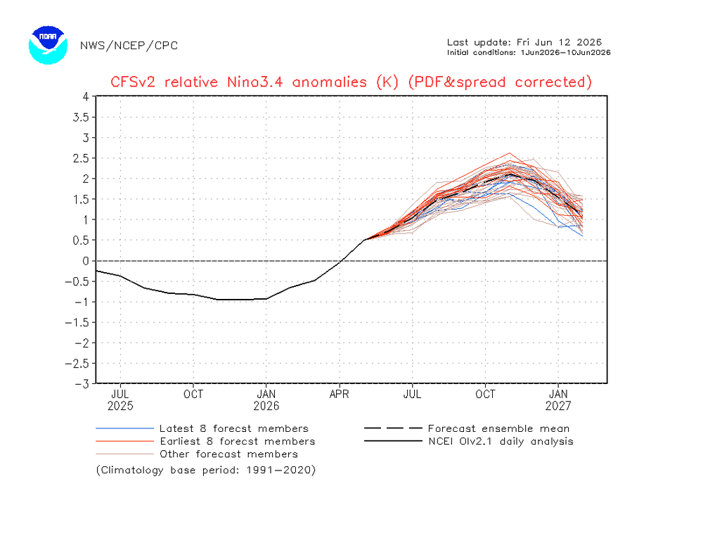
2026-2027 Super El Nino
mitchnick replied to Stormchaserchuck1's topic in Weather Forecasting and Discussion
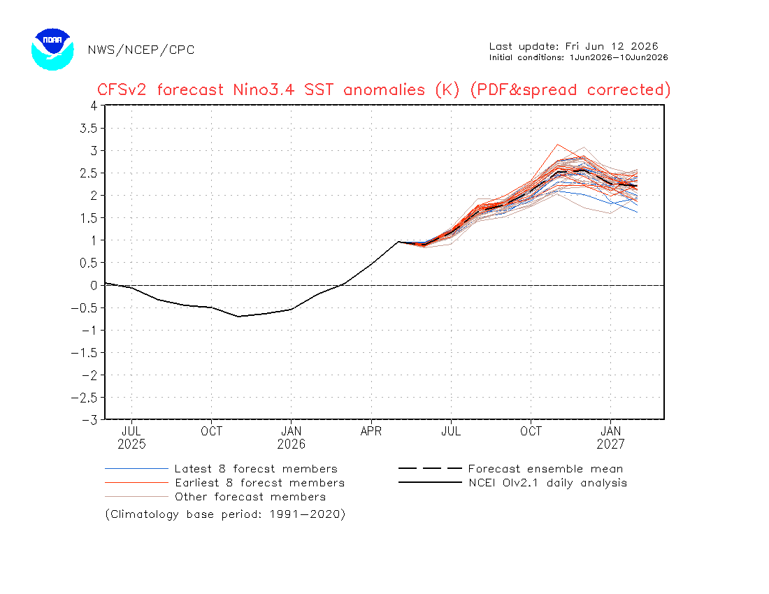
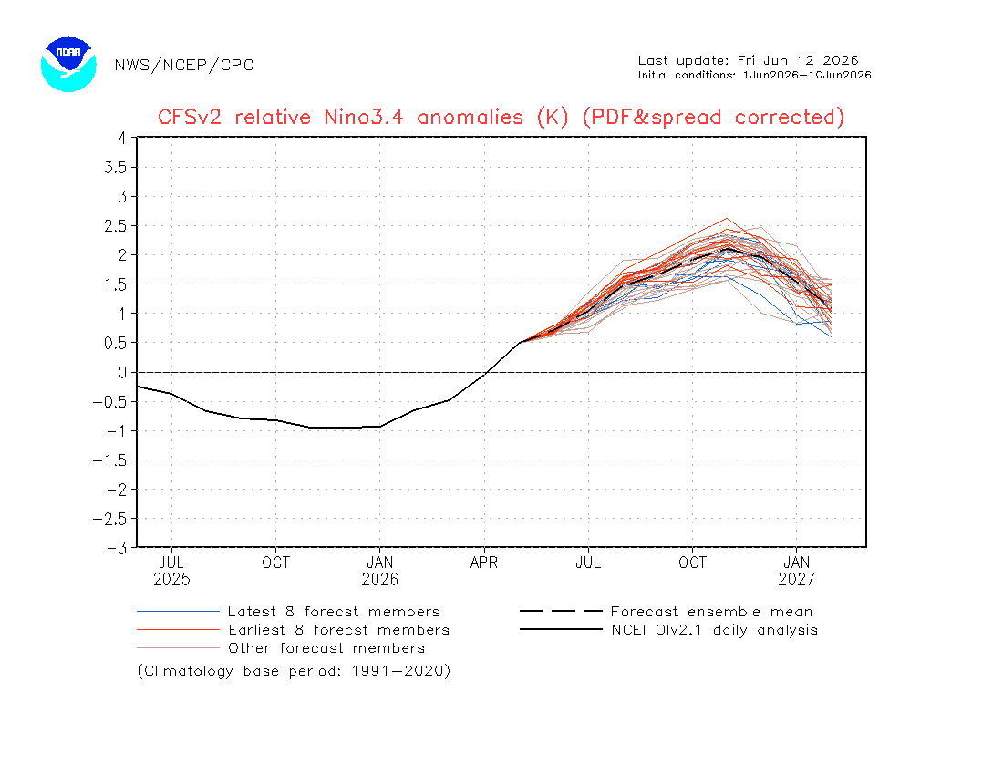
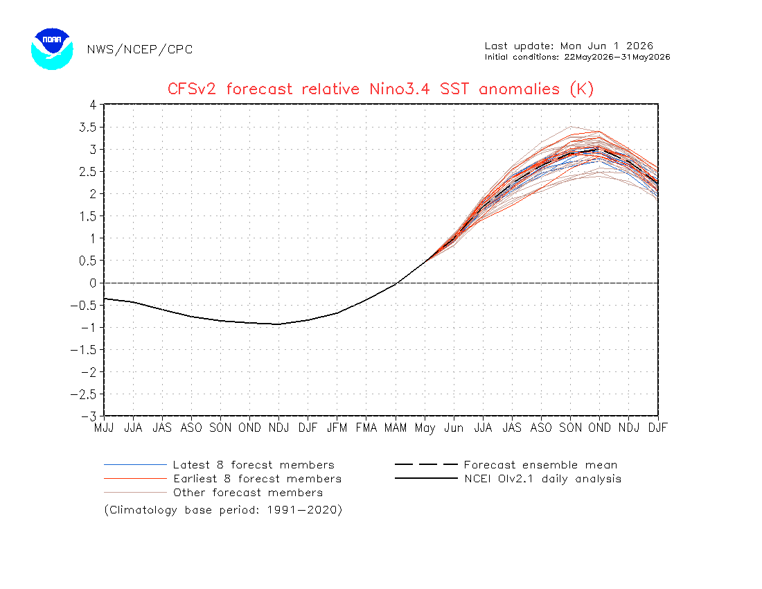
From someone who has, for better or worse, followed the Cfs2 forecast follies over the years, the bias corrected SSTA plumes have almost always been more accurate, whether warmer or cooler. Fwiw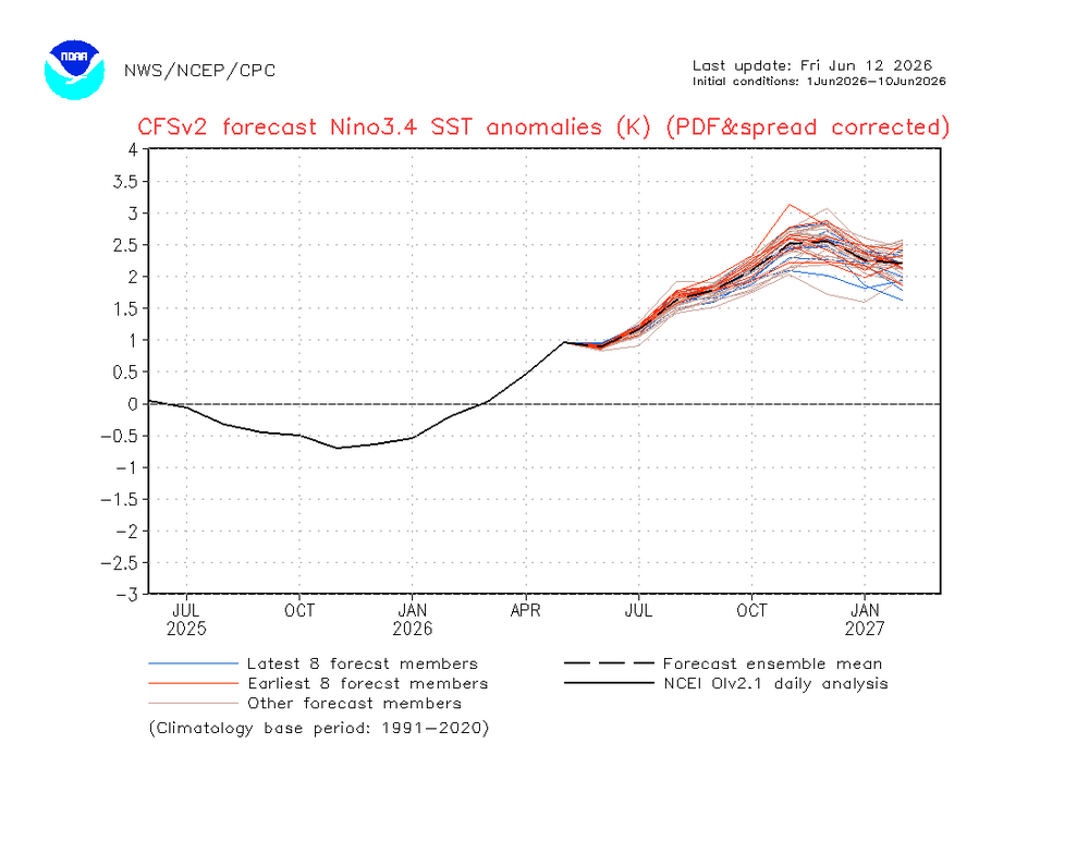
-
Okay ... heh I don't think this is the fault of the numerical models. All of them, including the NAM ... had 700 and 500 mb substantive RH pollution through mid afternoon today. Yet, the MOS (MET and MAV) guidance have "SC", which stands for scattered ( significant solar rad penetration inferred), with temperatures going birzirk to the mid 90s. At least for present hour, it's a reasonable explanation for the discrepancy. The interpretive algorithms ( MOS) are thus somehow statistically offsetting the objective guidance, which would be an error to do so in this case. The cynical explanation because I hate everybody ... this is a nice and tidy example of how you manufacture a bust... You get a "lazified" Met society, getting too used to slouch AI and tech in general to do their jobs for them, and in their reliance there is thus a lack of applied Meteorology to the data. A piece of shit work ethic that gets exposed when the these coffee break solutions in turn fuck up. Ha. I dunno... maybe the forecast gets saved by the bell so to speak if this grunge some how suddenly uncaps the sky.
-
That’s what she said. Got enough rain to wet the pavement here around 9:30-10 last night.
-
Trace at MHT. Epic.
-

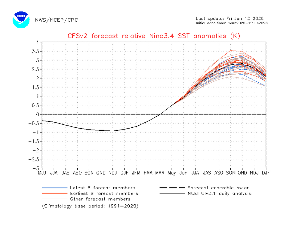
2026-2027 Super El Nino
GaWx replied to Stormchaserchuck1's topic in Weather Forecasting and Discussion
The latest CFSv2 release has actually cooled ~0.15 to 0.20 vs that from the start of June for the periods starting with JJA: June 1st release: relative peak ~+3.0 (OND) and rapid cooling to ~+2.25 DJF Today’s release: relative peak ~+2.8 (OND) and rapid cooling to ~+2.1 DJF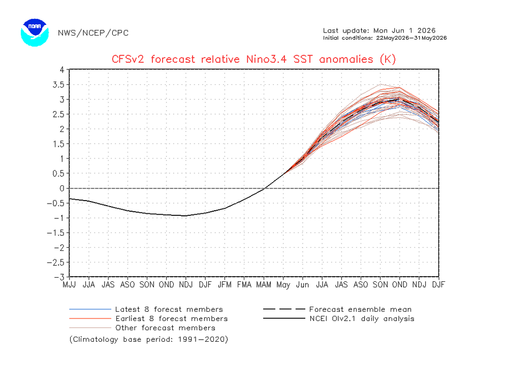
-
Was a mild storm at home...some twigs and leaves down; but drove to work this morning (3 miles east) and there's a fair number of small branches down. Live poplar mostly.
-

E PA/NJ/DE Summer 2026 Obs/Discussion
JTA66 replied to PhiEaglesfan712's topic in Philadelphia Region
Another overnight car-topper...er, 0.05" in the bucket. 78F/DP 71F -
Tonight looks dry