All Activity
- Past hour
-
We had a near record Southeast Ridge this summer. So record Atlantic warm pool is in the mid-latitude band off the East Coast. The record ridge back in the summer of 2023 was east of Canada leading to the record SSTs at higher latitudes.
-
What really gets me is all this hype information about La Nina winter coming. Like it's big headlines and it's going to be this strong La Nina. It seems to me that this La Nina pattern will be a very weak pattern and it won't even last all winter, but there's just so much out there on what they're saying. Honestly, the information is so misinformed on exactly what's going to happen that people just take what they read and go with it. Well in a week we'll be starting September and starting to get a better picture on where we're going. Starting to feel a bit of excitement.
-
 Yeah the big deal next week will be the very low humidity rather than the temps. Starting on Tuesday, a very long stretch with dewpoints in the 40s to near 50. That with high temps near 80 will be absolutely perfect summer weather.
 -
The North Atlantic is night and day this year compared to 2023. That big cold pool south of Greenland and up Davis Straight has been incredibly persistent since spring. Basically the opposite of the heatwave off of Japan in the Northwest PAC
-
the north end is cool
-
There isn't any 'new way' to fail. The way we win is the same as it has been lately with predominately -ENSO and the tendency for ridging in the EPO space. Time a wave moving along the thermal boundary when it's just to our south, and be content with light to moderate events. If we get really lucky maybe a couple pieces of energy phase early enough to get something bigger.
- Today
-
After a dry Aug in my neck of the woods, hoping for more precip starting in Sept. To me, it looks like a roller coaster pattern early, and later in Sept, with mid month sporting some very cool wx. Need the rain tho so as not to fall to far behind. Did well in July with it being the 8th wettest here in TH bringing YTD to near avg at the end of that month.
-
^Much nicer without any smoke. I swear, this year was one of the worst for that. More AQ alerts as the smoke was near surface many more days than the past few years. Probably because the fires were mainly concentrated in SC CAN than being more in the W CAN areas. With more distance, the smoke was more aloft then.
-
Currently cloudy and 71.1/65.8 at 11:20 am. Didn't get as cool as northern folks, think the clouds and fog held us up, low was 62.6 degrees this am.
-
This is the 1st time I can recall them going near 100% and them not designating it a TC at the next 6 hourly normal issuance time! If they’re waiting for recon, why not go 90%? Or why not issue a PTC advisory?
-
0.35" from a stm that moved through last night bringing the monthly total to 0.91" which is well below normal. Today feels like late Sept wx moved in on a NW wind. Highs in the 60's(maybe low 70's) with 30's/40's for lows the next few days. Great football wx tho.
-
Stein not helping matters
-
We just drove to Sugar Hill and the corn fields along the way are so dry that it looks like they’ve already had a frost.
-
 This week's cooldown looks to be just slightly below average now. Maybe a -5 on Wednesday with cool lows
 -
 Departures through 8/22 - two thirds of Aug Likely 2-3 above normal today/sunday and maybe monday, before below normal stretch Tue - Soundly putting all between 1.5-3 below normal for the month. EWR: -1.4 NYC: -1.8 JFK: -1.9 LGA: -2.6
 -
They're going crazy today. Not the day to eat outside.
-
AK : Hot fun in the summertime
-
this past week's cool - wonder if we'll see departures equal to these or if this period will be cooler overall than this coming week. EWR: 8/18: 78/ 66 (-4) 8/19: 76 / 68 (-4) 8/20: 71 / 60 (-10) 0.53 8/21: 75 / 60 (-8) 0.14 8/22: 85 / 60 (-3)
-
Records: Highs: EWR: 93 (1989) NYC: 92 (1916) LGA: 92 (1996) JFK: 91 (1978) Lows: EWR: 55 (1982) NYC: 51 (1923) LGA: 56 (1952) JFK: 57 (1994) Historical: 1683: A hurricane which made landfall in Virginia and moved from Virginia to Massachusetts. Extensive damage was done in Rhode Island, and the torrential rains from the hurricane caused the Connecticut River to rise 26 feet above its usual level causing a tremendous flood in the Connecticut Valley.(Ref. Hurricane of 1683) 1724 - An event is known as the "Great Gust of 1724" occurred on this day. Almost all tobacco and much of the corn crops were destroyed by this violent tropical storm, which struck the Chesapeake Bay. Intense floods of rain and a huge gust of wind were seen on the James River. Some homes were wrecked, and several vessels were driven ashore. The storm was likely followed by a second hurricane just five days later causing rain for many straight days that caused the Virginia floods of 1724. 1806: A hurricane of great size and destructive power raged along the Atlantic coast from the 21st to the 24th. As the slow moving storm gained forward speed, shipping suffered severely. The coastal ship "Rose in Bloom" capsized during the morning off Barnegat Inlet, NJ, with the loss of 21 of the 49 persons on board. This disaster received wide national publicity. Further north, Cape Cod, MA received 18 inches of rain, which ruined crops. The storm also caused major shipping losses. (Ref. Wilson Wx. History) 1851: The Great Middle Florida Hurricane of 1851 struck the area near Apalachicola and St. Marks. (Ref. AccWeather Weather History) 1906 - Thunderstorms deluged Kansas City, MO, with six inches of rain during the early morning, including nearly three inches in thirty minutes. (The Kansas City Weather Almanac) 1921 - Denver, CO, was drenched with 2.20 inches of rain in one hour, a record for that location. (The Weather Channel) 1933: A hurricane made landfall near Nags Head, North Carolina and tracked up the Chesapeake Bay. The Chesapeake-Potomac hurricane moved over Norfolk, Virginia, and Washington, DC. A seven-foot tide flooded businesses in Norfolk, Virginia. Described in the American Meteorological Society's August 1933 weather review as "one of the most severe storms that have ever visited the Middle Atlantic Coast." 1933 - The Chesapeake-Potomac hurricane moved over Norfolk VA and Washington D.C. A tide seven feet above normal flooded businesses in Norfolk, and damage in Maryland was estimated at seventeen million dollars. (David Ludlum) 1939: A long dry spell began in central Illinois. This was the first of 37 consecutive days where no measurable rain fell at Springfield, a record dry spell for the city. (Ref. Wilson Wx. History) 1955: Hail in Houston County, with piles to a foot deep at Rushmore, SD. (Ref. AccWeather Weather History) 1963: Project Stormfury was armed and ready as Hurricane Beulah moved across the Atlantic Ocean north of Puerto Rico. An armada of planes carried out the seeding and monitored the results of the experiment. On the 23rd, Beulah did not really meet the criteria for seeding. On the following day, the storm met the criteria of having a well-formed eyewall and the seeding appeared to be successful as the eyewall disintegrated. No other hurricanes would be seeded until 1969 because of a lack of good targets. (Ref. Wilson Wx. History) 1966: A bolt of lightning struck and killed a surfer who had just come out of the water while surfing at Surf City, NJ. The surfer was standing at the ocean's edge when lightning struck. (Ref. Wilson Wx. History) 1970 - Dry thunderstorms ignited more than one hundred fires in the Wenatchee and Okanogan National Forests of Washington State. Hot, dry, and windy weather spread the fires, a few of which burned out of control through the end of the month. More than 100,000 acres burned. (The Weather Channel) 1974: Brown's Summit, NC -- a 9-year-old girl was killed by lightning. Wawarsing, NY-- A 15-year-old girl was killed by lightning and five others were injured while camping during a thunderstorm. (Ref. Lightning-The Underrated Killer.pdf) 1987 - A cold front brought autumn-like weather to the Northern and Central Plains Region. Afternoon highs were in the 50s and 60s across parts of Colorado, Kansas and Nebraska that just two days earlier were in the 90s or above 100 degrees. Thunderstorms produced locally heavy rain in New Mexico, Texas, Oklahoma and Arkansas. (The National Weather Summary) 1988 - Thunderstorms produced hail an inch in diameter, wind gusts to 64 mph, and 2.62 inches of rain at Tucson AZ resulting in three million dollars damage. Cool weather prevailed in the northeastern U.S. Hartford CT reported a record low of 42 degrees. (The National Weather Summary) (Storm Data) 1989 - Thunderstorms produced heavy rain with flash flooding in West Virginia. Pickens, WV, reported 4.80 inches of rain in 24 hours. Evening thunderstorms in Mississippi deluged Alta Woods with 4.25 inches of rain in less than an hour. Thunderstorms also produced heavy rain in southeastern Kentucky, and flooding was reported along Big Creek and along Stinking Creek. The Stinking Creek volunteer fire department reported water levels 12 to 14 feet above bankfull. Fort Worth TX hit the 100 degree mark for the first time all year. Strong winds ushering cool air into northwest Utah gusted to 70 mph, raising clouds of dust in the salt flats. (The National Weather Summary) (Storm Data) 1992 - While South Florida residents were preparing for Hurricane Andrew, folks in western Montana were dealing with early season snowfall. Some snowfall amounts include 8.3� in Great Falls, 6.2 in Helena, and 5.1 in Cut Bank. This snowfall is the first significant snowfall on record in western Montana in August. 1998: Massive flooding caused by heavy rains from the remnants of dying Tropical Storm Charley struck the town of Del Rio, TX. 18 inches of rain fell from Sunday night through Monday morning. At least 13 people died in the flooding in Texas and Mexico. The town of Del Rio had been parched by seemingly endless drought before the rains started had had less than 3 inches of rainfall for the first seven months of the year. (Ref. AccWeather Weather History) 1999: In Sanford, ME, a man playing a video game in the American Legion building was injured when a lightning strike arced through all the video machines. He suffered chest pains/hearing problems. (Weather Guide Calendar with Phenomenal Weather Events 2011 Accord Pub. 2010, USA) 2001: Scattered strong thunderstorms developed during the evening hours of the 22nd in west central Illinois, continuing into the early morning hours of the 23rd. Excessive rain fell during this period, and produced widespread urban and street flooding. Cooperative observer rainfall observations ranged from 6.30 to 8 inches in Hancock County from this event. In Schuyler County, a total of 8.67 inches of rain fell in Brooklyn. On the LaMoine River, levels rose up to 16 feet in only 4 to 6 hours. (Ref. Wilson Wx. History) 2005 - Hurricane Katrina formed from Tropical Depression Twelve over the southeastern Bahamas. Katrina would become the costliest ($81.2 billion) and one of the most deadly hurricanes (1,836 lives) in U.S. history. 2011: Earthquake today at 1351 that lasted 30 seconds that was rated a 5.8 magnitude and the epicenter was near Mineral, Virginia. The quake was the biggest in Virginia in 114 years since May 5, 1897, when a 5.8 tremor began in Giles County and was felt in 12 states. The Charleston, SC earthquake of August 31, 1886 was a powerful intraplate earthquake the strongest earthquake recorded in South Carolina. The shaking occurred at 9:50 p.m. and lasted just under a minute and is estimated to have been between 6.6 and 7.3 on the Richter scale. The earthquake caused severe damage in Charleston, South Carolina, damaging 2,000 buildings and causing $6 million worth in damages (over $141 million in 2009 dollars), while in the whole city the buildings were only valued at approximately $24 million. Between 60 and 110 lives were lost. After the 1811 and 1812 quakes in New Madrid, Missouri, the Charleston SC earthquake is the most powerful and damaging quake to hit the southeastern United States. Three Main Shocks of the Missouri Earthquake, December 16, 1811 - Magnitude ~7.7, January 23, 1812 - Magnitude ~ 7.5, February 7, 1812 - Magnitude ~ 7.7. Also in 1755, a quake with around a 6.0 magnitude struck off the coast of Massachusetts.
-
Yup CON still sits at 0.20”…going for the 3rd driest summer month on record. The forsythia and chestnut out front have shriveling leaves.
-
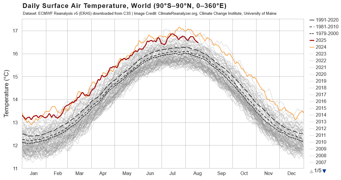
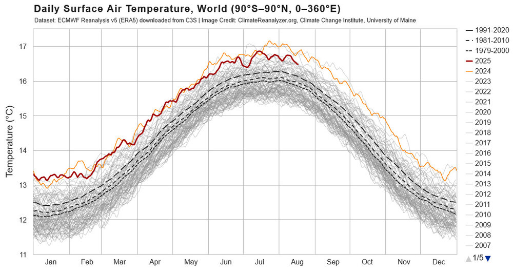
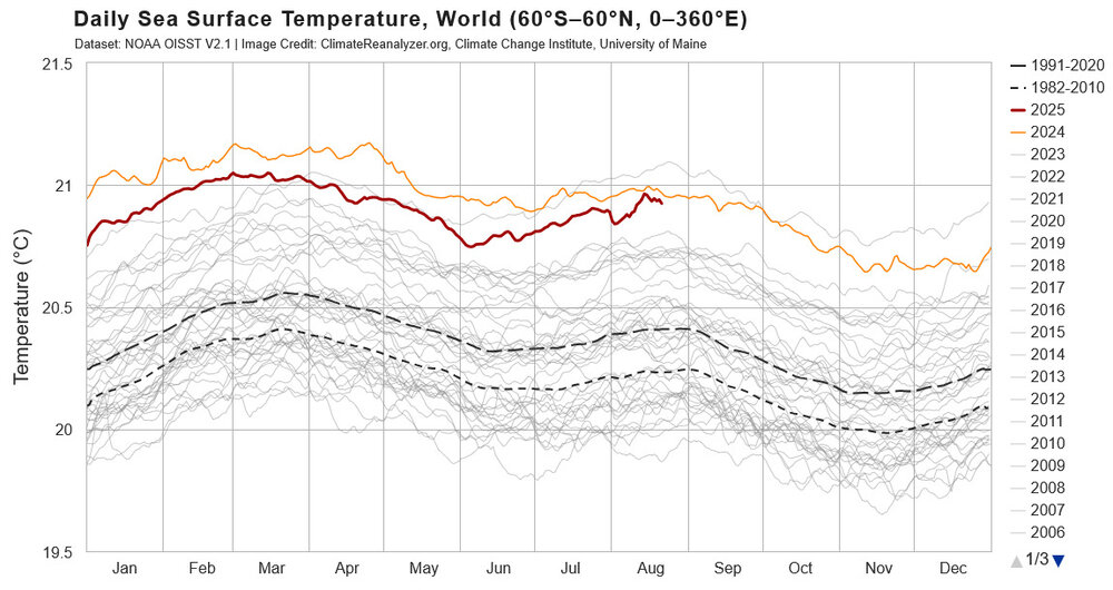
It is interesting to compare the current standing and recent trends in SST vs global temperatures. Comparing to 2024, SST have risen through the year particularly in summer months, while global temperatures have cooled relative to 2024. Difficult to compare 2025 to 2023 because of the strong rise in temperature in 2023, but just looking at August, both SST and global temperatures are somewhat cooler in 2025 vs 2023. Comparing 2025 to pre-2023 years, SST is currently warmer than any year by a good margin, while global temperatures are not well clear of the pre-2023 years. Taken as a whole, 2025 SST is like 2023, unusually warm for the enso condition; but, unlike 2023, global temperatures are not unusual for the enso state. Mid-latitude marine heat wave probably playing a role . Will be interesting to track as summer turns to fall. Guessing SST will cool will warm relative to other years and global temperatures will warm; but, we will see.
-
76 / 55 another gorgeous day on tap mid - upper 80s in the hottest areas. Some clouds tomorrow but dont think its completely cloudy with the mainly dry front. Trough moves in and depsite the trough looks like a relatively nice week / dry and slightly below normal highs and cooler lows. Moderation towards normal by the 31 and warmer overall beyond there not a way below or above - near normal.
-
To be fair any of the globals out that far could predict the Cubs winning the Super Bowl lol. However the NHC did mention using Google DeepMind's forecast in a few of it's discussions on Erin (in an experimental capacity). I will say this. I'm strongly suspect of some the discussions coming out of our local office. They have a very "machine" like feel to them at times, especially on weekends. I'm sure it's coming big time. It's inevitable
-

E PA/NJ/DE Summer 2025 Obs/Discussion
ChescoWx replied to Hurricane Agnes's topic in Philadelphia Region
A nice weekend underway with temperatures today through Monday close to our average high temperature around 80 degrees for the end of August. We turn much cooler by Monday night and that should last through much of next week. Some of the typically colder valley locations may see lows by both Wednesday and Thursday night in the upper 40's. Highs by mid-week may barely escape the 60's across the higher ridges across the area. We continue to be very dry across Northern Chester and SE Berks counties so far here in August. Our best chance of a little is tomorrow night.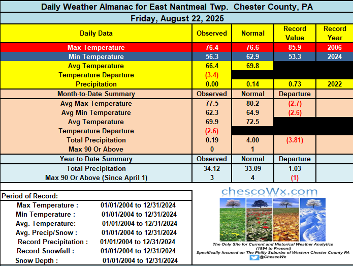
-
A nice weekend underway with temperatures today through Monday close to our average high temperature around 80 degrees for the end of August. We turn much cooler by Monday night and that should last through much of next week. Some of the typically colder valley locations may see lows by both Wednesday and Thursday night in the upper 40's. Highs by mid-week may barely escape the 60's across the higher ridges across the area. We continue to be very dry across Northern Chester and SE Berks counties so far here in August. Our best chance of a little is tomorrow night.