All Activity
- Past hour
-

2026-2027 Super El Nino
40/70 Benchmark replied to Stormchaserchuck1's topic in Weather Forecasting and Discussion
Yes, this. -
you have a chance of flooding rain very soon - Flood Warning says between 2 - 32 inches -lol FFW from KPHI problem today is these areas of heavy rain just develop very quickly
-
2026-2027 Super El Nino
40/70 Benchmark replied to Stormchaserchuck1's topic in Weather Forecasting and Discussion
He's saying that ridging is underestimated in this modern era, so where ever ridging is denoted, it's highly likely that seasonal guidance will be too cold and low with heights in that area...regardless of where it is. -
Probably. The 12z is even wilder-especially eastern areas.
-

Hoisting the Sultan Signal: Heavy Rain Event July 5-7
weatherwiz replied to WxWatcher007's topic in New England
Goes very wild with the llvl jet -
This will be off by 5" in my area
-

Hoisting the Sultan Signal: Heavy Rain Event July 5-7
ineedsnow replied to WxWatcher007's topic in New England
didn't even see your post.. either its drunk or someone floods -
Hoisting the Sultan Signal: Heavy Rain Event July 5-7
ineedsnow replied to WxWatcher007's topic in New England
12z HRRR going wild in some spots -

Hoisting the Sultan Signal: Heavy Rain Event July 5-7
CoastalWx replied to WxWatcher007's topic in New England
12z hrrr went drunk. wtf is that lol. -

Central PA Summer 2026 Discussion/Obs Thread
Jns2183 replied to Voyager's topic in Upstate New York/Pennsylvania
I am thankful for the 70's. I have all my windows upon and got my house temp down to low 70's. They haven't seen to make a dent in the power outages near me so I'm assuming it's pretty much a complete collapse. Sent from my SM-S731U using Tapatalk -
2026-2027 Super El Nino
40/70 Benchmark replied to Stormchaserchuck1's topic in Weather Forecasting and Discussion
I get what you are saying...there is some hyperbole going on, but I also think that you should be a bit more measured with respect to your own tone, as well....while the position of that GOA low is more redolent of the stronger composite than the weak data set, it's also not very representative of the east-based composite, either. I would expect that the season would cool down beyond December extrapolating out. Weaker (left) vs Stronger (right) Modoki (Left), Basin-Wide (Center) vs East-Based (Right) -
I can't wait for my 4th STW and warnings in a row that don't produce anything lol. .02 yesterday
-
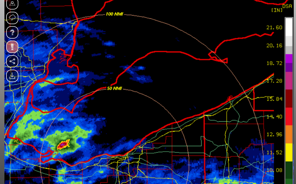
You don't see 15"+ rainfall estimates very often. The island area took a beating last night. We could really use more rain here locally... heaviest rains have been hit or miss.
-
Loving the steady rains across Central NJ right now.
-
Good news: The 12z HRRR gives me >1" of rain. Bad news: The rain is supposed to be falling right now.
-
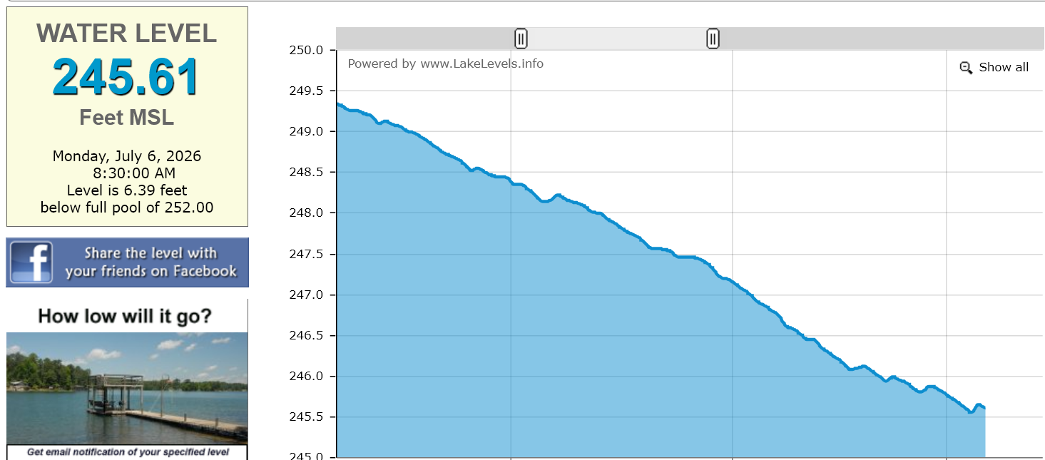
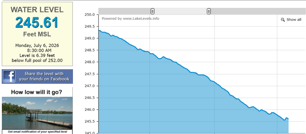
This graph shows the bump from yesterday's rain at Falls Lake before resuming the gradual drop:
-
 65° sure feels nice.
 -

2026-2027 Super El Nino
mitchnick replied to Stormchaserchuck1's topic in Weather Forecasting and Discussion
Where'd that come from? Lol Just be happy with the 1-2C+ the Euro is showing for the NE and hope for warmer next time. -
In Garner it was not measurable-sad
-
As I have been commenting on for a while now, these expansive marine heatwaves and associated 500mb patterns can exert an influence on our weather and climate which is independent of ENSO. So at times the other marine heatwaves and associated 500mb patterns can drive the sensible weather. Then at other intervals the ENSO can have a more direct effect. Still on other occasions there is an overlapping influence. https://www.science.org/doi/10.1126/sciadv.adz4647 Marine heatwaves in the Northwestern Pacific (NWP) have become increasingly frequent and persistent, yet the mechanisms enabling their multiseasonal duration remain poorly understood. Through observational analyses and climate model experiments, we demonstrate that NWP marine heatwaves are primarily driven by a quasistationary wavenumber 5 circumglobal wave (CGW) pattern that operates independently of El Niño–Southern Oscillation. The CGW modulates surface heat fluxes during summer, triggering a self-reinforcing feedback loop where NWP warming intensifies the CGW pattern, amplifying and prolonging heatwaves across extended warm seasons. Additionally, CGW-driven summer warming in the northern North Atlantic persists into winter through oceanic thermal inertia, exciting a great-circle wave pattern that propagates back to the NWP, sustaining heatwaves through cold seasons. This interplay between atmospheric waves and trans-basin interactions enables multiyear marine heatwave events. Analysis of observational data and climate model simulations reveals a strengthening CGW influence in recent decades, indicating more frequent and prolonged NWP marine heatwaves under ongoing global warming.
-

Hoisting the Sultan Signal: Heavy Rain Event July 5-7
Chrisrotary12 replied to WxWatcher007's topic in New England
Easy forecast for my location: 0-3” -

Occasional Thoughts on Climate Change
Typhoon Tip replied to donsutherland1's topic in Climate Change
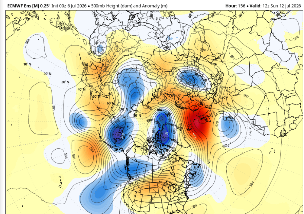
Don, what we feared is clearly materializing in the current ensemble means from all major source. This is what I saying a week or so ago when I kidded you, 'if you wanna look brilliant, warm Europe now'. This flow construct below is just as idealized, and it is also taking place closer to the climatological apex of the N.H. summer - altho the climate doesn't/shouldn't modulate discrete forecasts, but it does buffer doubt when considering the repeating aspect here - it's hard to knock consistency. UK and the Iberian Peninsula at under the gun again.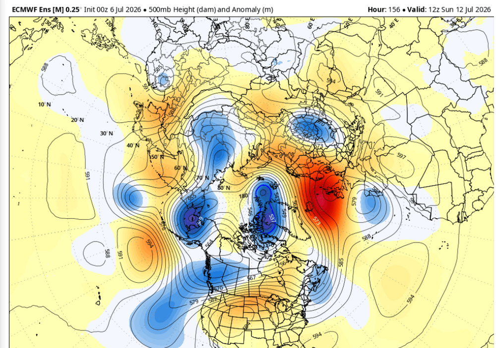
-
Occasional Thoughts on Climate Change
Typhoon Tip replied to donsutherland1's topic in Climate Change
An aspect you doubter and/or deniers and/or skeptics may need to consider more closely is that H20 in the atmosphere requires heat to maintain vapor form. I'm reading a lot in here that is entirely temperature related, but global warming/climate change is vastly more complex. The temperature is but a smaller fractional evidence of the total global quota in additive heat. That heat in homogenized atmosphere is taken from the kinetic temperature ( which is the temperature on the thermometers). That means as more water evaporates into gaseous form, the temperature metric comes down. The metric that measures the amount of moisture in the air, the Dew Point, rises. This tells you that the heat must also be rising. This can be masked if one focuses on temperature alone. 110F/ 55 is, by thermodynamic physical laws, colder than 99/80. By a large amount in fact. The ambient water vapor in the atmosphere is corroborated across multiple disciplines, from direct empirical measure to eventually satellite spectroscopy, altogether altogether demonstrating the ambient planetary water vapor has risen since the IR. Where is it getting its heat required to do so? C02, and then secondarily other species like CH3/4 (Methane) ... etc, are added to the ambient global atmosphere. These enhance storage capacity i.e., more heat stored. This causes a positive feedback. It adds to the baselines green-house physics (1), but of more import this heat (2) in turn provides more heat to evaporate more moisture. This process is called thermodynamics of phase changes; when also involving multiple compounds in the arithmetic, the contributing roots to GW is non-linear. I would suggest remedial education into the physical processes involved. By understanding that, you might light bulb that attribution science is something you could and definitely should understand before you doubt. -

2026-2027 Super El Nino
bluewave replied to Stormchaserchuck1's topic in Weather Forecasting and Discussion
You have to realize that the actual pattern isn’t always what you want it to be. -
Another nice day on tap with temps in the 70's. Lake breeze more E today will be less chilly than NE breezes.