All Activity
- Past hour
-
I had a green one that looked like a Borg ship cube
-
Canadian is definitely the best region wide outcome
-
Once again I will say… yes, I am an asshole but I am right about you. At least I am trying to be better by only being that way to people who deserve it
-

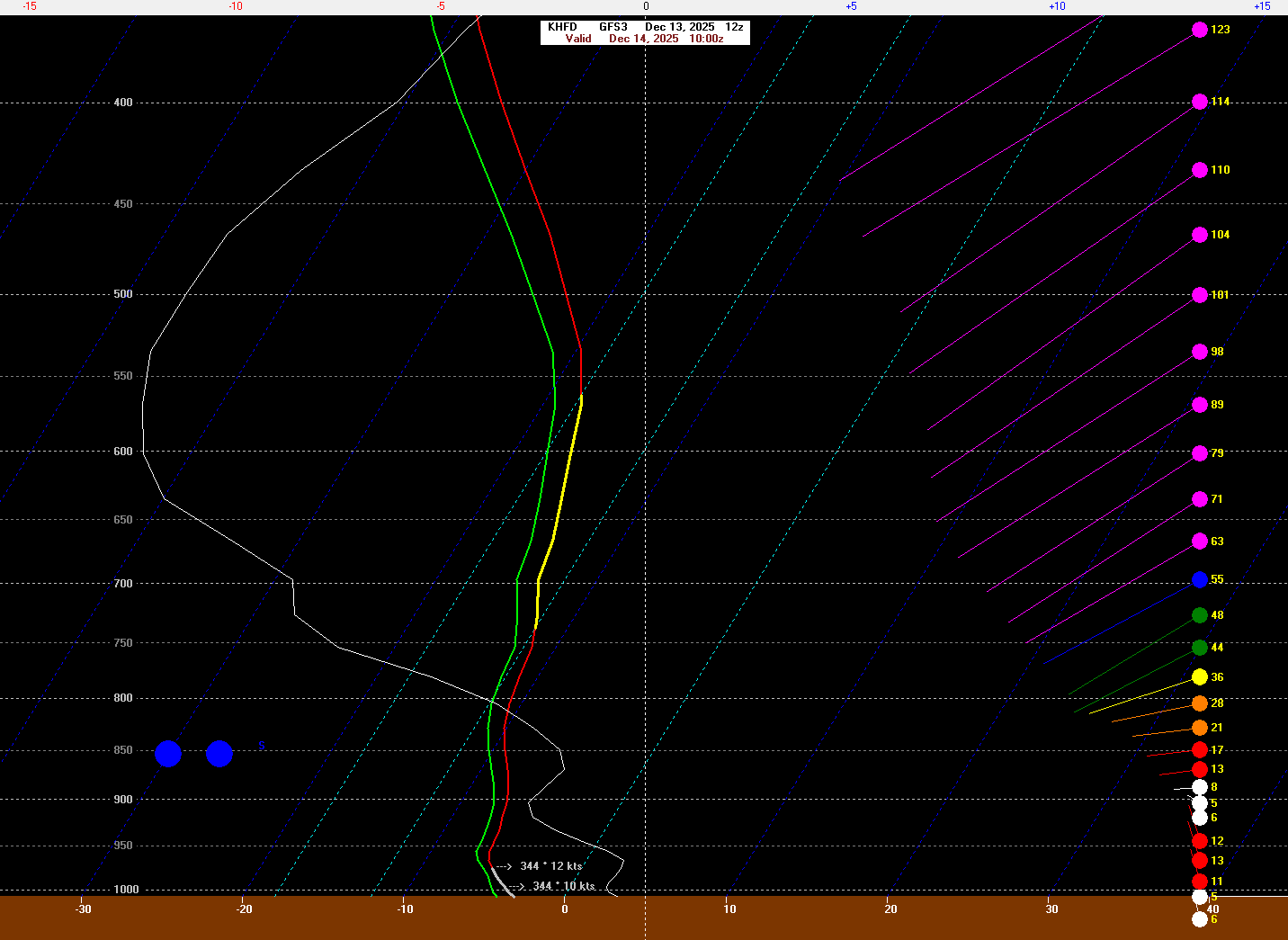
Saturday night/Sunday 12/13-12/14 Jawn
Birds~69 replied to Ralph Wiggum's topic in Philadelphia Region
Nap accordingly... 38F/Cloudy -

December 11th-14th Double Banger Clippers
Chicago WX replied to Jackstraw's topic in Lakes/Ohio Valley
Rip city here. Everything has gone to sh*t. Looks like we got lucky and was far enough “south” to get into some good banding. Probably won’t last long, but it’s nice to have received… -
I’m getting a “ Delayed but….” Feeling for the onset of rain to snow
-
thanks man! where can i find your forecast?
-

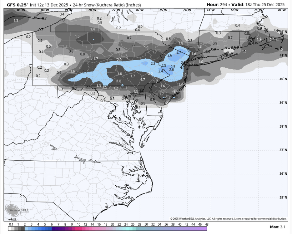
December 14th - Snow showers or Plowable snow?
CT Rain replied to Sey-Mour Snow's topic in New England
The GFS has only 0.15" of liquid in Hartford but this is a damn good snow growth setup.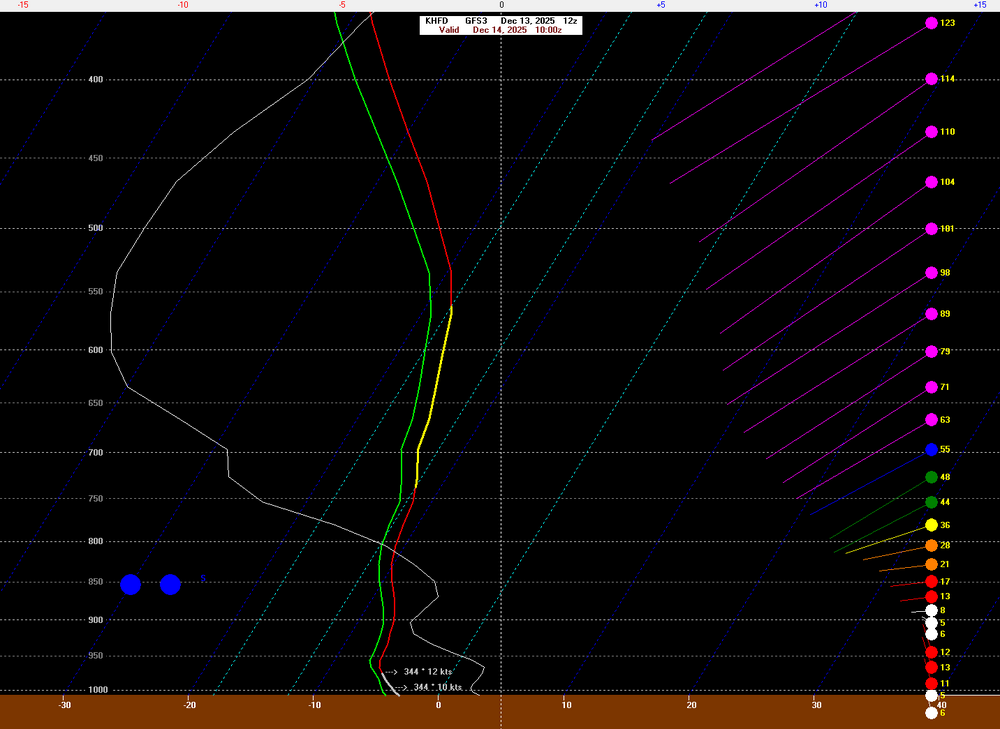
-
And spotted lanterns .
-
"It's a Christmas Miracle!"
-
For the ninth year in a row, it will rain on New Years Eve! Two things in your life that you can count on, is Christmas week tourch and rain at New Years!
-

December 14th - Snow showers or Plowable snow?
dendrite replied to Sey-Mour Snow's topic in New England
I think it’s the low probability of a little weenie norlun I mentioned. That may explain the shape too. -
That whole evolution from day 12 on is just wacky. Would love to see it play out like that lol
-

December 11th-14th Double Banger Clippers
cyclone77 replied to Jackstraw's topic in Lakes/Ohio Valley
It's all good, we've had a phenomenal season already. Gonna take a 2-3 week break from snow, but hopefully we can resume the snowy pattern after the New year. -

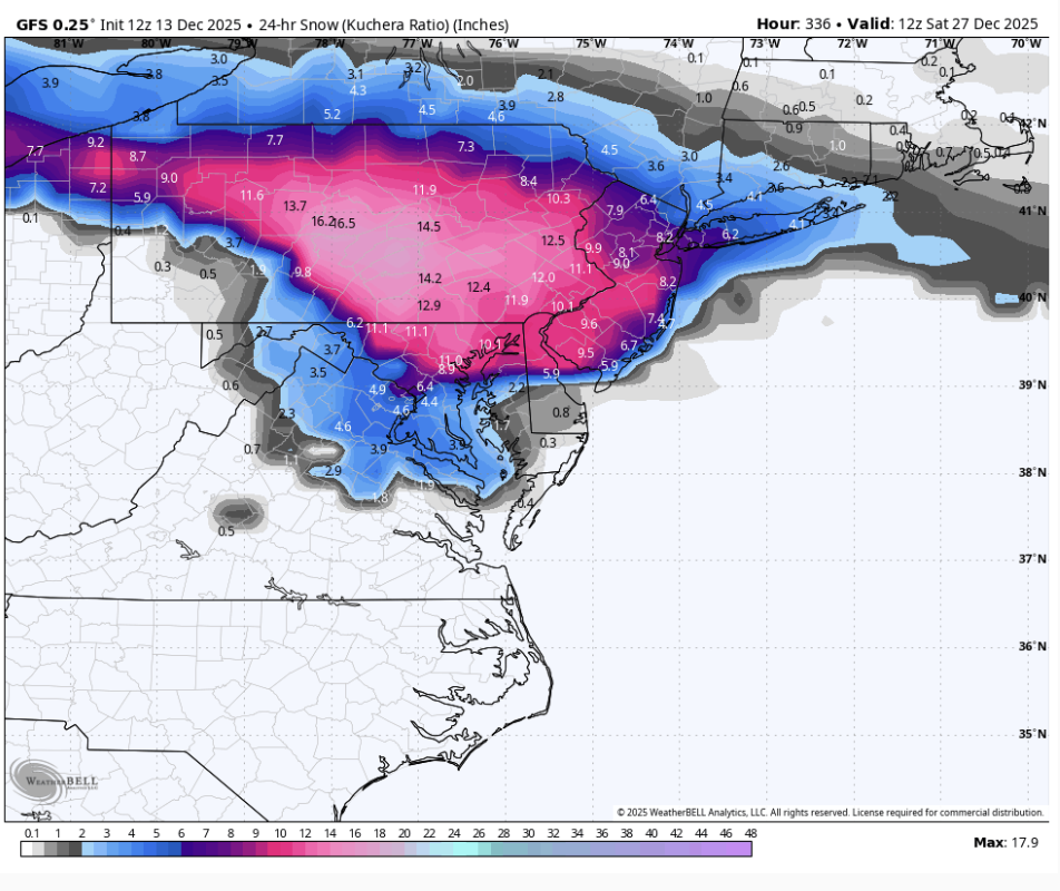
Moderate snowfall 12/14/2025 WWA up for most of the area
bluewave replied to WeatherGeek2025's topic in New York City Metro
It’s too bad they discontinued the banding product from FSU. These charts were nice to have in the past. But the exact spot of the banding and subsidence is almost always a nowcasters special. Robert Hart, Florida State University https://moe.met.fsu.edu › banding Experimental NAM and GFS Banding Diagnostics. Note: The NAM output is ... Archive of recent images. Bob Hart, FSU David Novak, WPC Walt Drag, NWS PHI -
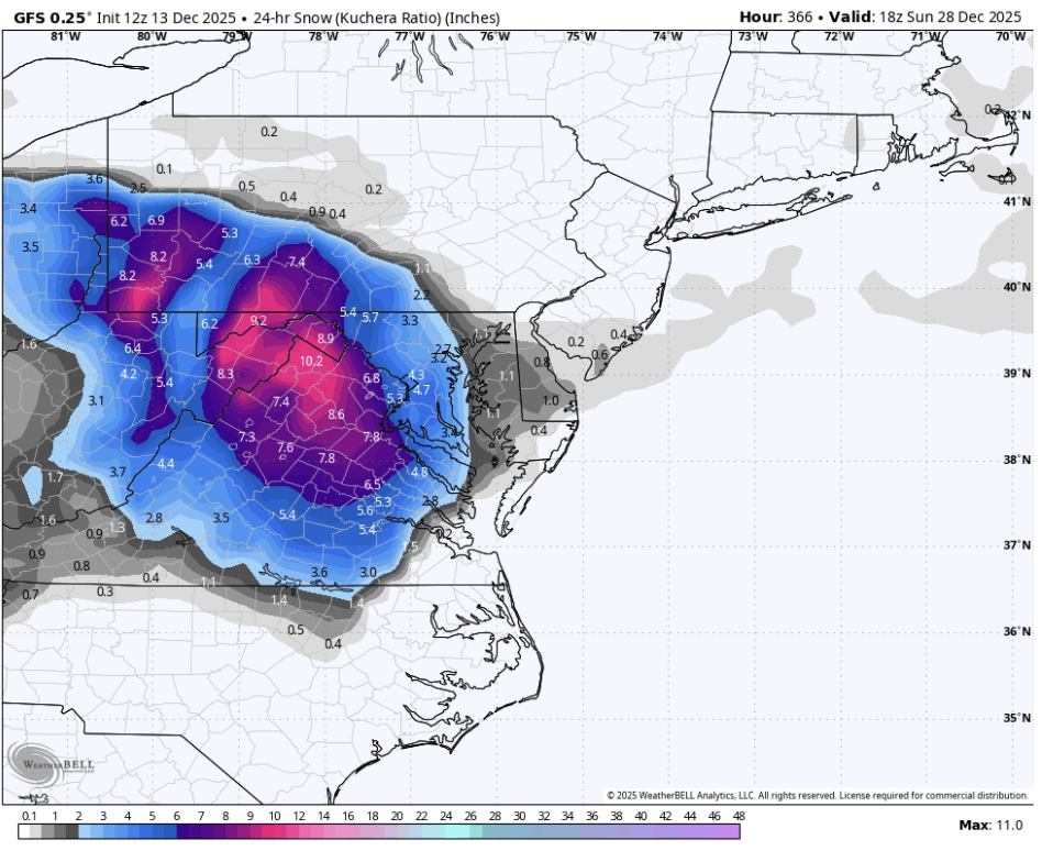
GFS has THREE events around Xmas. Dec 25, 27, and 28-29! What a weenie run!


-

Saturday night/Sunday 12/13-12/14 Jawn
LVblizzard replied to Ralph Wiggum's topic in Philadelphia Region
Don’t mind it at all. I’m usually up till 2-3 am anyway…gonna enjoy the late night silence tonight with moderate fluffy snow falling. -
I remember that one and could see that as a scenario where this could bust.
-

12/14: Sunday funday? Will the south win again?
nw baltimore wx replied to TSSN+'s topic in Mid Atlantic
For anyone wishing for LWX to issue warnings, we almost always do better when they play catch-up. I don't need to see my house in the pink map. Just let it snow! -
Yeah, SNE has been in rough shape as well. C/NNE have done much better. Tracks have not been right for the stretch of coast from NJ to LI to SEMa. Easy for Va to pile up nickel and dime events when everything is suppressed/shredded and weak, with no amplification to drive the waves northward. Happy this one appears to be working out.
-

December 2025 Short/Medium Range Forecast Thread
Daniel Boone replied to John1122's topic in Tennessee Valley
Good,valid point. Post this in the Main Forum and you'll have many going Nuts over there ; particularly the Warmanista and GW brainwashed One's. They'd probably justify the Model's doing that. Fact is, GW is real to a degree but, the Cause and Forecasted Rate is off. Not to say your Post is about GW, just giving an Opinion on why you're right on your Suspicion. -

Saturday night/Sunday 12/13-12/14 Jawn
Duca892 replied to Ralph Wiggum's topic in Philadelphia Region
Went to work expecting around an inch for Whitehall and leaving work and expecting around 2-3in. Nice nice -
Really coming down here now, starting to accumulate on grass/vegetation, not much on the roads yet though. Temp is just below 32f, so hopefully it starts dropping soon and we see some higher ratio stuff move in
-

Pittsburgh/Western PA WINTER ‘25/‘26
meatwad replied to Burghblizz's topic in Upstate New York/Pennsylvania
URGENT - WINTER WEATHER MESSAGE National Weather Service Pittsburgh PA 1141 AM EST Sat Dec 13 2025 OHZ057-058-PAZ021-WVZ002-140215- /O.UPG.KPBZ.WW.Y.0024.251213T1800Z-251214T1800Z/ /O.EXA.KPBZ.WS.W.0008.251213T1800Z-251214T1800Z/ Muskingum-Guernsey-Allegheny-Brooke- Including the cities of Pittsburgh Metro Area, Wellsburg, Zanesville, Follansbee, and Cambridge 1141 AM EST Sat Dec 13 2025 ...WINTER STORM WARNING IN EFFECT UNTIL 1 PM EST SUNDAY... * WHAT...Heavy snow expected. Total snow accumulations between 4 and 7 inches. * WHERE...In Ohio, Guernsey and Muskingum Counties. In Pennsylvania, Allegheny County. In West Virginia, Brooke County. * WHEN...Until 1 PM EST Sunday. * IMPACTS...Travel could be very difficult. PRECAUTIONARY/PREPAREDNESS ACTIONS... Please report snow or ice accumulations by calling 412-262-1988, posting to the NWS Pittsburgh Facebook page, or using X @NWSPittsburgh. && $$ -

12/14: Sunday funday? Will the south win again?
winter_warlock replied to TSSN+'s topic in Mid Atlantic
True.. lol


.thumb.jpg.ad3a2e31d30aff035044689b311a0540.jpg)