All Activity
- Past hour
-
Let's get it a few more ticks for good measure.
-

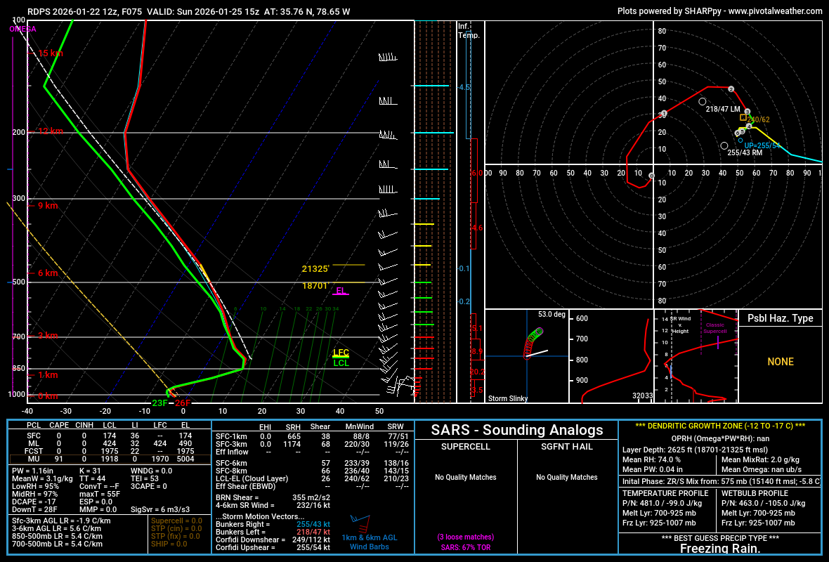
January 25/26 Jimbo Back Surgery Storm
NorthHillsWx replied to Jimbo!'s topic in Southeastern States
It tries so hard to keep @BornAgain13 snow for the first 6 hours -
Same for the RGEM. It does have a good period of sleet but heavy ZR with temps in the low to mid 20s

-

Central PA Winter 25/26 Discussion and Obs
Blizzard92 replied to MAG5035's topic in Upstate New York/Pennsylvania
So much for my flight to the Annual Meteorological Society meeting on Sunday! -
So mixing remains minimal for the region? Or is that just for higher elevations?
-

January 24-26: Miracle or Mirage JV/Banter Thread!
H2O replied to SnowenOutThere's topic in Mid Atlantic
I think we have time to go every direction like a Wonkavator -
You hate to see it, Carver. We still hold some cards. But it's getting dangerously close to the event. I will say we've been very lucky the past three to four decades regarding heavy ice accumulations. I think it was even '77 or '78 the last time KTRI saw icing on a scale that could play out in this event. Hopefully, it does not.
-
Someone way smarter than me told me to go where the money is when picking a career. So I chose entrepreneurship in finance, private equity and health science Later in life, someone much smarter than them told me to go where you feel the most fulfilled. Now I am a builder and developer I don't totally disagree; however, I do feel as that science is well-funded and emphasized, but often times you have people like me making the wrong career choices for the wrong reasons (chasing $$$$ v using your powers for good)....I actually wanted to go into meteorology when i was a teenager, but went a different scientific route in school/grad school (pharma chem)
-

“Cory’s in LA! Let’s MECS!” Jan. 24-26 Disco
40/70 Benchmark replied to TheSnowman's topic in New England
Maybe N trend has stabilized. -
January 24-26: Miracle or Mirage JV/Banter Thread!
H2O replied to SnowenOutThere's topic in Mid Atlantic
insert flaming cyclone of death over short pump -
@TSSN+ @mitchnick @HighStakes The warm layer at the end of the NAM is really thin and only around +1 around h7 for our area, it shows as sleet but heavy enough precip would be able to mix that out...it would probably still be a mix of snow/sleet depending on intensity through the end of the run up here...the dryslot was coming soon after anyways.
-

Central PA Winter 25/26 Discussion and Obs
Voyager replied to MAG5035's topic in Upstate New York/Pennsylvania
With my schedule, I can't shop until Saturday. It'll probably be a madhouse with the usual items sold out. -
The RGEM run ends at 7pm Sunday and looks basically over. What are you looking at?
-

Possible Record Breaking Cold + Snow Sunday 1/25 - Tuesday 1/27
BoulderWX replied to TriPol's topic in New York City Metro
yup; 6-10 seems right for most; still laughing thinking about people two days ago talking about 20/25:1 ratios This is a classic SWFE event where we thump and end as sleet -
Just an example/reminder of what even .30in of ZR looks like.
-
All depends on where, Its 0.30" less up here.
-

Possible Record Breaking Cold + Snow Sunday 1/25 - Tuesday 1/27
mob1 replied to TriPol's topic in New York City Metro
I am not hating the 12Z suite so far, 6-10 inches of snow followed by some sleet. -
It's weird looking at these 2 GIFs. the top one has the 6z slamming a LP into TN and 12z its gone. Bottom one as a 6z LP into middle KY and 12z the triangle of KY/TN/VA. It's like the 12z are sniffing out a stronger HP to the north each run and adjusting. If stout walls of cold can stay above it will be interesting to see if the models move to a colder solution or still find ways to punch warm noses into our areas
-

January 24-26: Miracle or Mirage JV/Banter Thread!
MillvilleWx replied to SnowenOutThere's topic in Mid Atlantic
@MountainGeek @clskinsfan @Wxtrix @DDweatherman Appreciate all the responses from my little inquiry on hosting me out towards your area, or helping with designating where to stay if I were to chase out that direction. Looks like some friends of mine out by Martinsburg said they would love to host me, so I think that’s the route that I’ll end up going. I’ll confer later today, but again, I appreciate the responses and warm welcome (Clskinfan) to your home. Should be a fun storm with a heck of a front end thump, at the very least for your areas. Enjoy!! -

“Cory’s in LA! Let’s MECS!” Jan. 24-26 Disco
TauntonBlizzard2013 replied to TheSnowman's topic in New England
Icon looks great here. Printing out 1.25-1.50 liquid equivalent in eastern ma. even with marginally better than 10:1 ratios, that’s an 18” snowfall. -
On WxBell, it has trended colder. Slide the freezing line south one county and ditto run to 6z.
-
January 22 1982: The Twin Cities receive 21.1 inches of snow, with a total of nearly 40 inches on the ground. 1936: Perhaps the coldest wind chill the Twin Cities has ever seen occurs on this day; it hits -67 with the new wind chill formula (-87 with the old formula). The temperature was -34 with a wind speed of 20mph. All traffic in the Twin Cities was severely hampered and a number of fatalities were caused by the cold. For Thursday, January 22, 2026 1943 - Chinook winds during the early morning hours caused the temperature at Spearfish SD to rise from 4 below zero to 45 above in just two minutes, the most dramatic temperature rise in world weather records. An hour and a half later the mercury plunged from 54 above to 4 below zero in twenty-seven minutes. (David Ludlum) 1987 - A winter storm spread snow from central Mississippi through northern Georgia to New England. Up to 15 inches of snow fell across the heavily populated areas of Virginia, Maryland and Delaware. Traffic tie-ups nearly paralyzed the Washington D.C. area. Winds gusted to 76 mph at Chatham MA, and in Pennsylvania, snowfall totals ranged up to 21 inches at Dushore. Williamsport PA received five inches of snow in just one hour. (National Weather Summary) (Storm Data) 1988 - The nation was free of winter storms for a day, however, winds in southern California gusted to 80 mph in the Grapevine area of the Tehachapi Mountains, and winds along the eastern slopes of the Rockies reached 100 mph in the Upper Yellowstone Valley of Montana. (National Weather Summary) (Storm Data) 1989 - Low pressure brought heavy rain and gale force winds to Florida. Daytona Beach was drenched with 5.48 inches of rain in 24 hours to establish a January record for that location, and winds at Titusville FL gusted to 63 mph. (National Weather Summary) (Storm Data) 1990 - It was a very tame and peaceful mid winter day. Mild weather prevailed across the nation, with rain and snow primarily confined to the northeastern U.S. and the Pacific Northwest. Warm weather continued in Florida. Highs of 83 degrees at Hollywood and 85 degrees at Miami were records for the date. (National Weather Summary) 2000 - A severe ice storm hit northern Georgia and portions of northwest South Carolina on January 22-23. Over half a million utility customers were without power during and after the storm, with the Atlanta area severely affected. 2005 - A major winter snowstorm, referred to as the Blizzard of 2005, affected the Northeastern United States. More than one foot of snow covered much of southern New England in the storm's aftermath, with well over two feet in some areas of Massachusetts. Strong winds created blizzard conditions with low visibilities and considerable blowing and drifting of snow. (NCDC)
-
12z RGEM a good bit colder. @BornAgain13hr 64 is def worthy of posting. Hell of a WAA thump verbatim for your area north up toward me.
-
January 25/26 Jimbo Back Surgery Storm
NorthHillsWx replied to Jimbo!'s topic in Southeastern States
And more QPF -

Central PA Winter 25/26 Discussion and Obs
GrandmasterB replied to MAG5035's topic in Upstate New York/Pennsylvania
So far using the NAM and ICON, I liked the small trends at 12Z on both models. Slightly later phasing and a little flatter heights to our east. Now onto the big boys!