All Activity
- Past hour
-

January 30th- Feb 1st ULL and coastal storm obs
Ravens94 replied to JoshM's topic in Southeastern States
RAP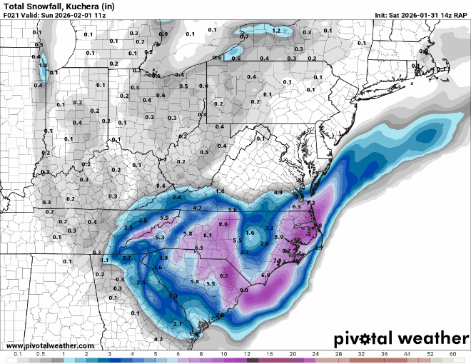
-

January 30th- Feb 1st ULL and coastal storm obs
hrtsdsn replied to JoshM's topic in Southeastern States

-

January 30th- Feb 1st ULL and coastal storm obs
airmarci replied to JoshM's topic in Southeastern States
getting pasted in the Triad right now...went out to blow snow and the top of the driveway had another inch by the time I got to the bottom -

Arctic Hounds Unleashed: Long Duration Late January Cold Snap
CoastalWx replied to WxWatcher007's topic in New England
Probably a lot of non sheltered instruments too. You get that sometimes with snowpack reflecting light back too. -

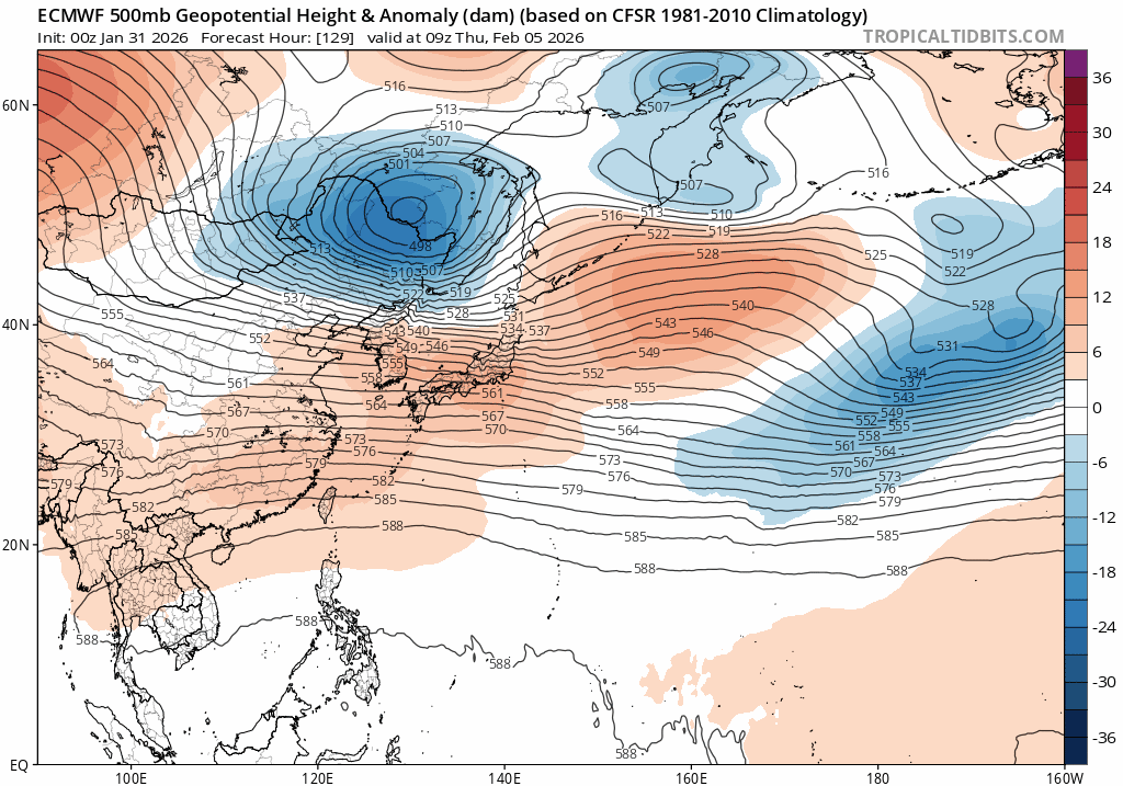
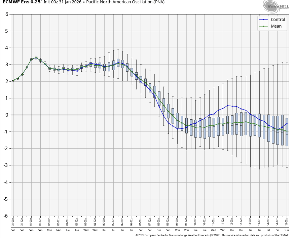
February 2026 Medium/ Long Range Discussion: Buckle Up!
87storms replied to Weather Will's topic in Mid Atlantic
Not qpf. The Carolina’s are showing us how it’s really done. -
(002).thumb.png.6e3d9d46bca5fe41aab7a74871dd8af8.png)
E PA/NJ/DE Winter 2025-26 Obs/Discussion
ChescoWx replied to LVblizzard's topic in Philadelphia Region
A weenie view of a classic it's coming north radar hallucination. Who else is feeling January 2000? coming north.mp4 -
Arctic Hounds Unleashed: Long Duration Late January Cold Snap
CoastalWx replied to WxWatcher007's topic in New England
WTTTE -
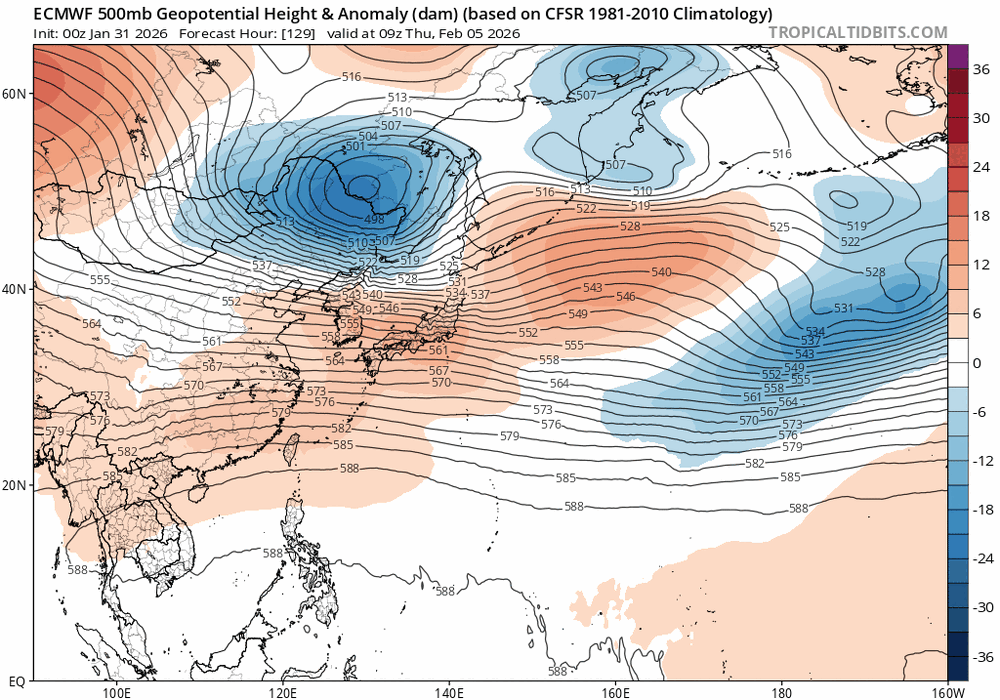
Gonna be a Valentines Sweetheart for someone and the Kiss of Death for someone.Hard to figure this one out but its still a couple weeks out.GEFS shows the NAO/PNA possibly crapping out FOR US,but we are talking two weeks away/JMA has the MJO moving through P1-2,thats typically a cold look in J/F/M
-

The Jan 31 Potential: Stormtracker Failure or 'Tracker Trouncing
anotherman replied to stormtracker's topic in Mid Atlantic
Let the radar hallucinations begin. -
March 2018 was epic in Suffolk. Nor’easter every weekend
-

January 30th- Feb 1st ULL and coastal storm obs
yotaman replied to JoshM's topic in Southeastern States
I can verify. Snowing hard now. Big flakes. ground starting to get covered. Currently 25. Wind chill is getting brutal. -
RAP says we have a long long way to go. A lot of back building showing up in the short range modeling. Gonna be interesting to see.
-
The “I bring the mojo” Jan 30-Feb 1 potential winter storm
audioguy3107 replied to lilj4425's topic in Southeastern States
yeah, looks like this is going to be our "right place at the right time" storm, happens every 10 to 15 years or so. We may be in the Georgia sweet spot....I've already got close to 4 inches over here off Braselton Hwy & Hamilton Mill Rd. -

January 30th- Feb 1st ULL and coastal storm obs
WinstonSalemArlington replied to JoshM's topic in Southeastern States
Winston-Salem Beltway -
Yes check your sensor mine was doing the same thing cleaned it out now down from 24.7-20.6
-

February 2026 Medium/ Long Range Discussion: Buckle Up!
bncho replied to Weather Will's topic in Mid Atlantic
Doesn't the flip to a slightly -PNA/+EPO regime counteract the dry issue with strong -NAOs, while also guaranteeing that most systems that hit us will be cold enough for snow (due to that strong -NAO)?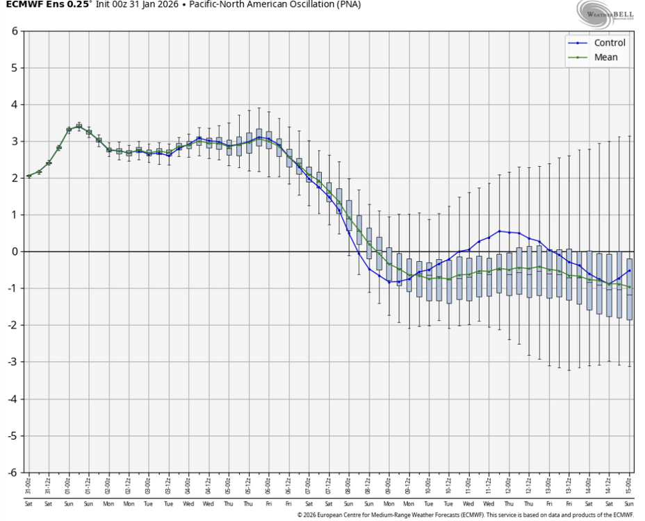

-
The “I bring the mojo” Jan 30-Feb 1 potential winter storm
NEGA_Dawg replied to lilj4425's topic in Southeastern States
Ring camera pic after 2.5 hours of snow and the rail has about .500 inch. Heavy small flakes at the moment.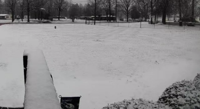
-
Avery County, NC reporting around ~7”
-
The first ten days of Feb were supposed to be warm-ish as in back to normal...and IDK if that is actually gonna work out. Take a look at the 12z GFS....one chance after another. I do think mid-month is a good window. But Wednesday has to be watched as does next weekend. Saturday-Monday is a window as well w/ a chance at a strong cold front. I am not even sure we are done w/ below zero stuff after early this week. I will say this...at some point this bitterly cold pattern is gonna break, even if spring forces it. And yes, I do think we have a warm ridge rolling through at some point, but I have to be honest...I am good w/ a few warm days. I need to thaw out. Morning runs w/ wind chills below 5F are not fun.
-
The “I bring the mojo” Jan 30-Feb 1 potential winter storm
Aleksey replied to lilj4425's topic in Southeastern States
20z and 21 show another convection band right over us! . -

Central PA Winter 25/26 Discussion and Obs
Rd9108 replied to MAG5035's topic in Upstate New York/Pennsylvania
When's the last time the Northeast had a winter like this where DJF were all below average with a constant snow pack for weeks?? -
Suppression ? I thought you liked February . Too early to write off the whole month .
-
 3 to 5 hour snow event now? Even if we get 7 inches this will still be a major bust based off that! Lol
 -

Arctic Hounds Unleashed: Long Duration Late January Cold Snap
Ginx snewx replied to WxWatcher007's topic in New England
Sun feels great -
Arctic Hounds Unleashed: Long Duration Late January Cold Snap
Ginx snewx replied to WxWatcher007's topic in New England
Danielson Arp is 21 an ASOS