All Activity
- Past hour
-

2026-2027 Super El Nino
LakePaste25 replied to Stormchaserchuck1's topic in Weather Forecasting and Discussion
I do think we should still shy away from “recent nino events have featured a persistent W pac warm pool, so this one will too.” I think it’s a forecasting trap. Probably true that we deal with it much more frequently, but i don’t believe there’s enough evidence to suggest it’s a permanent feature. It’s very possibly we get clean canonical forcing by the fall. In fact I think we are on track to see that. It will just take stronger events such as this one to start seeing it. -
86/73
-
I think RDU has a shot to break the all-time record again. RAH calling for 102 and RDU has a habit of exceeding that during dry periods as you outlined
-

2026-2027 Super El Nino
George001 replied to Stormchaserchuck1's topic in Weather Forecasting and Discussion
DC-NYC yeah but Boston is a bit different in that average snowfall is in the low 40s, so our area really needs either 1 big one + several smaller events or 2 big ones. In super ninos we don’t usually see those smaller ones, and the bigger ones tend to be more Miller A due to the strong southern jet which often run inland a bit and rain in Boston or go out to sea. Thats why these super ninos tend to be not great for us. Not only do we not get those minor events that add up in super ninos, the storm track when the big one does hit if it does often screws us. It’s basically the opposite of the southern mid Atlantic, they tend to get fucked over by Miller Bs and clean up in miller As, coastal SNE cleans up in miller Bs and often gets fucked over in miller As. This is a big reason why I’m not too thrilled about the upcoming super Nino for my area, but we will see how things play out. -
If this initial MCS stays further south, you think the warm front may be closer to I-80 corridor or even further south for the next round? LOT AFD sort of alludes to this.
-
To be fair, many thought it would be a cooler June, due to this being a pre-strong nino summer. Such Junes/summers are notorious for being cooler, like 1972, 1982, 1997, 2009, and 2023. The only real exceptions to this rule were 1991 and 2015, and both were preceded by a warm neutral ENSO winter. That wasn't the case this year.
-

Central PA Summer 2026 Discussion/Obs Thread
canderson replied to Voyager's topic in Upstate New York/Pennsylvania
I don’t love today’s changes. We’ll see. -
Phil will be going crazy today
-

Central PA Summer 2026 Discussion/Obs Thread
Voyager replied to Voyager's topic in Upstate New York/Pennsylvania
83/71 at 10:30am. She sure is muggy today. We've got a good deal of sun here currently, so good fuel for storms later I suppose. -

E PA/NJ/DE Summer 2026 Obs/Discussion
The Iceman replied to PhiEaglesfan712's topic in Philadelphia Region
30% wind probs today and tomorrow for most of the area... decent soaking last night for my area, picked up a quick .40". SPC day 1 ...Mid-Atlantic ad central Appalachians... Forcing for ascent from multiple shortwave disturbances across the northeast and dewpoints in the 60s to 70s F will support development of widely scattered thunderstorms by afternoon across the Mid-Atlantic into the central Appalachians. Though vertical shear will be generally weak, moderate to strong instability will be in place will support stronger updrafts capable of damaging winds. It is likely that several clusters will emerge with potential for organizing along cold pools and more focused corridors of damaging wind potential. -

2026-2027 Super El Nino
bluewave replied to Stormchaserchuck1's topic in Weather Forecasting and Discussion
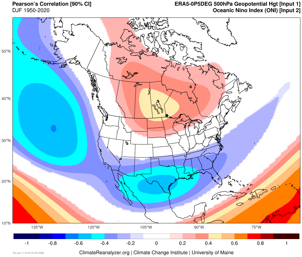
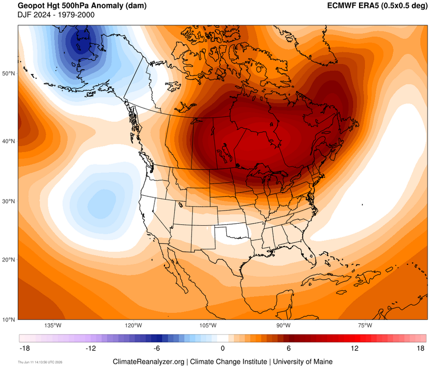
It appears that the -PDO through the warm pool east of Japan and active MJO 4-7 caused the Aleutian low to split into two weaker low pressure centers. Probably why the -1.5 RONI was so far behind the ONI. But for the Great Lakes into Northeast the El Nino ridge was even stronger than would be expected with a +2.1 ONI. Could also be the general expansion of mid-latitude ridges leading to the lack of a strong trough response in the Mid-Atlantic and Southeast.
-

Junorch obs and discussion 2026
TauntonBlizzard2013 replied to Damage In Tolland's topic in New England
Bone dry here overall. Hate to see it -
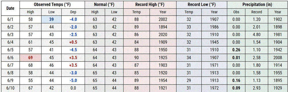
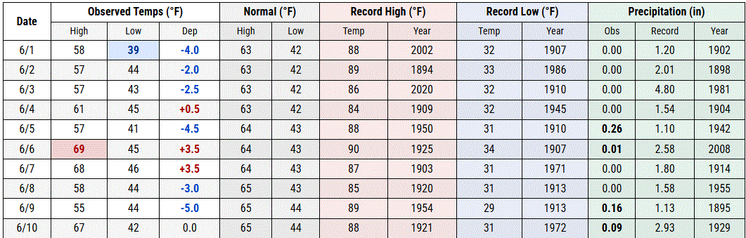
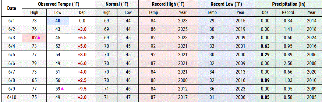
So absurd, most places have seen mean high temps in/near top 10 warmest on record for first decade of June. Philadelphia - 5th warmest; Providence, RI - 3rd warmest; Newark, NJ - 9th warmest. But Central Park is at 36th warmest. Closest analog is Worcester, MA at 23rd warmest, but their station thread includes decades from a station hundreds of feet lower in elevation.
-
Wow, that's a mean lookin Dercho bitch about to unleash fury on Iowa City
-
Junorch obs and discussion 2026
TauntonBlizzard2013 replied to Damage In Tolland's topic in New England
Yeah. I keep looking for signs of real sustained heat in the long range and it’s not really there -
Morning low of 65 here, first 60+ minima of the season. First TD near/at 70 as well.
-
sort of... As Brian was intimating, there was conjecture/interpretation for a cooler first half of June back whence. I personally give that the benefit of the doubt ( although privately ... there are those that falter implementation of any 'cold bullshit filter' so they may have a bias contribution that it's totally going so snow on July 20th ... weeee Excluding that contribution though ), but in doing so, was adding the notion: it seems that verifying warmer than guidance is overwhelmingly the observation compared to colder than guidance, regardless of future patterns being offered. I mean it may have even verified a cooler "looking" pattern, but for whatever reason ( probably CC, let's get real - ) your likely to flop on the warm side.
-
84/77 soupy n steamy
-

Junorch obs and discussion 2026
TheClimateChanger replied to Damage In Tolland's topic in New England
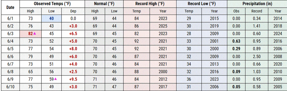
It has certainly been a solid first decade of June for summer weather lovers in the northeast IMHO. Many places are in the top 10 for mean maximum temperature - including Caribou, ME (5th), Concord, NH (4th), Providence, RI (T-3rd), and numerous other sites around the region. Would expect these to trend even higher. Was it supposed to be cold or something? -
How is it already 85° out? I think today will be day 15 of no rain too, so nothing to cool it off.
-
Overnight crapvection shunted the real instability south as usual. Maybe 1-94 but I’m hosed up here. Michigan.
-
Nothing but sunny skies here in IKK since daybreak, thought it might be an overcast start to the day
-
Two notable storms in Feb 1969. The late month "100-hour" storm was a New England event; we had 4" of mush at our NNJ home. The storm of 9-10 was the "Mayor Lindsey" snow. The NYC forecast had been heavy cold rain, but the 15.3" of heavy wet snow that paralyzed the city as the sanitation crews (plows on garbage trucks) were not alerted. The head of the sanitation union said of Lindsey, "He played it by ear but was stone deaf!" Our scout troop was at Allamuchy Scout Camp in NW NJ that weekend, but my 1962 Beetle had no problems even though there was 8-9" new by the time we got home that Sunday.
-
I believe we will see some changes regarding expectations for today. Let the HRRR catch up to reality over the next few runs, and we’ll likely see a clearer and different picture painted.
-
Big difference between shoreline wx, and inland wx here at Two Harbors. TH Co-op 7 am readings (on the shore) TH 7NW Co-op 7 pm readings (inland)