All Activity
- Past hour
-
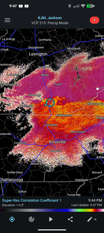
850 frontogenesis might be the cold front pressing down. Check out the wind barbs over MD and WV panhandle compared to central VA. Watch this area closely for a deathbed to set up.
-

2025-2026 Fall/Winter Mountain Thread
Tyler Penland replied to Buckethead's topic in Southeastern States
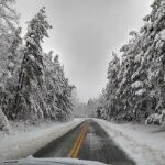
Sleet/rain mix here in Foscoe. Saturated a bit quicker than I thought to be honest. Currently 32. Sent from my Pixel 10 Pro using Tapatalk -
700mb frontgen is entering the southern parts of our region were now at Nowcasting time! Also some weird line of 850 frontgen over NOVA that has been strengthening over the past couple hours. Anyone know whats up with that?
-

December 2025 regional war/obs/disco thread
Sugarloaf1989 replied to Torch Tiger's topic in New England
19F currently. Forecast low of 6F. Still full snow-cover. -
Get out there with a squirt gun and point it skyward. Do your part. Edit: Also ICON a smidge north/wetter
-
Early on, but it's good to see mPING reports following the darker returns. Maybe the dry air won't be stubborn?
-
Yeh, don’t think this one is even gonna be particularly close. Oh well. .
-

E PA/NJ/DE Winter 2025-26 Obs/Discussion
Birds~69 replied to LVblizzard's topic in Philadelphia Region
Sounds like something JB would say to gain subscriptions.... 27F -
Temp down to 34 no precipitation.
-
Sleet/rain mix in Raleigh
-
Looks like its the band hits Charlottesville a couple hours earlier (4am sounding for refence). Will be a fun Jebwalk! (sorry to my poor roommate who has to deal with that though). But what a thing of beauty compared to the HRRR runs we were looking at earlier.
-
Down to 26 here
-
The sleet monster has taken over. Punt next > ❄️
-
Gonna suck going back to regularly scheduled Decembers
-
Well I guess the present thinking is that we’re due for snow here in the NYC metro. We’ve had snow just to our north, just to our west (today and a few days ago) and now to our south for DC and people further south. At some point I’m assuming we’ll get on board just to fill in the map lol. Hopefully soon. It’s truly looking like this is the coldest December since 2013. In terms of the snow department; who knows? But we will have enough cold. Let’s hope we have enough snow as well
-
Raining and 44° here in the triad. This is a non-starter. Next!
-
KBOS METARS tell the story: KBOS 042354Z 30017G32KT 10SM -SN SCT033 BKN049 OVC070 M02/M11 KBOS 050054Z 29026G47KT 10SM FEW060 M03/M21 A3012 KBOS 050154Z 31018G34KT 10SM FEW060 M04/M19 A3015 Squall comes through, dewpoint drops from 12˚F to -6˚F with the 47KT gusts, and then rises as it slackens off a bit. I live under the departure path for RWY 33 and can't really tell if the noise I'm hearing is the wind or the aircraft. It's a mixture of both.
-

December 4th through 5th 2025
Daniel Boone replied to Holston_River_Rambler's topic in Tennessee Valley
Area's east of the Appalachian Spine have very low DP'S. Definitely going to help them get all Snow all the way down to possibly Winston Salem NC. Too bad we were stuck with high DP's . Would of made a difference irt cooling. That or just have been 2-3 degrees colder at all levels than it is. So close but yet so far. -
Get clocked Christmas Day. We wake up to an amber sunrise that leads to a steel grey sky. Just after lunch snow starts falling and it's a solid 8" - 12" of cold powder that ends just before midnight. Then on New Year's Ever we get a nice clipper running along I-64 that put another 4" - 6" of sugar on top.
-
We need a good 2009, 2010 or 2016 storm. Everyone here will be in a lot better mood.
-
We will this year.
-
I know it’s OT, but I have a Xmas tree farm trip planned for tomorrow. There was 1 other time it was snowing while going and it’s kind of magical for me. I’m such a snow ho.
- 866 replies
-
- 11
-

-

Pittsburgh/Western PA WINTER ‘25/‘26
Ahoff replied to Burghblizz's topic in Upstate New York/Pennsylvania
8, 1, and 2 are all good ones right? -
wow! The models never had 8" around Fort Collins for that storm New winter storm warning above 9000 ft today.
-
Yes.