All Activity
- Past hour
-
Given the recent precip shift I would love to know what they’re smoking.
-

Central PA Summer 2026 Discussion/Obs Thread
WmsptWx replied to Voyager's topic in Upstate New York/Pennsylvania
Sun is out and I need there to not be any storms as it is Fair Day for me and mine. Also, return to Vail is slated for September. Not that it'll matter this year with the megatorch that's coming but maybe I'll luck out. -

2026 Mid-Atlantic Severe Storm General Discussion
Eskimo Joe replied to Kmlwx's topic in Mid Atlantic
Historically, we do not have multiple severe weather days in these parts. The radar trends in the Ohio Valley are not encouraging for those east of the Potomac River later today. -
big guidance fail. instead we had a cluster develop south of sioux falls. now we have an mcs, which has struggled to mature and organize as it has crossed iowa all morning.
-
Not behaving like any of the other strong Ninos so anyone thinking this winter will be a repeat of those strong Nino years needs to think twice
-

Augdewst 2026: Summer's Last Stand
Typhoon Tip replied to Prismshine Productions's topic in New England
...a notion sullied interminably more creepy if he were say ... publishing rancid bum porn and Klondike bar was gettin busy with that, too huh -
The HRRR is pretty much nada now as well.
-
Nothing new here, summer seems to hang on in these parts until early October, last October I believe the cooler weather might have arrived a bit sooner, I know it was very dry though. https://www.accuweather.com/en/weather-forecasts/fall-forecast-2026-summer-warmth-may-linger-as-el-nino-intensifies/1915201 Where will fall feel the warmest? September may feel more like an extension of summer across parts of the country, especially in the mid-Atlantic and southeastern U.S., where the above-average temperatures will be paired with high humidity and warm nights. It may not be until October before the first intrusions of chilly air arrive in the north-central Plains, Great Lakes and Northeast, but these cold outbreaks are not expected to be long-lasting. Worsening drought could also contribute to the warmth, including in the mid-Atlantic, interior Northwest and across the Rockies, where there are pockets of extreme to exceptional drought. The same dry pattern may also keep wildfire danger elevated into early fall, resulting in episodes of smoky conditions downwind of large blazes.
-
Perhaps Bill is posting concert dates and set lists from the 1990's online and in a weird kind of way you guys are still really close.
-
 canadian pharmacy store official website: Maple Trust Rx - medication canadian pharmacy
 -
Heck of a complex this morning. I go to my office at 7 am, I can’t remember ever having back to back days with a severe thunderstorm warning when leaving the house
-
comma head/waa wing taking shape now
-
Conveyor belt of smoke in the upper levels from the PAC NW it seems with the wind at 200mb & 500mb and the ridge centered W of us. Wonder how much it’ll impact high temps some days.
-
The 13z SPC D1 outlook update still keeps us on the outside looking in. 15% well SW of the metro areas.
-
Augdewst 2026: Summer's Last Stand
Typhoon Tip replied to Prismshine Productions's topic in New England
Out of left field model observation: I wonder if there's a warm burst (record?) cooking up in the models up there in Alaska around the 16th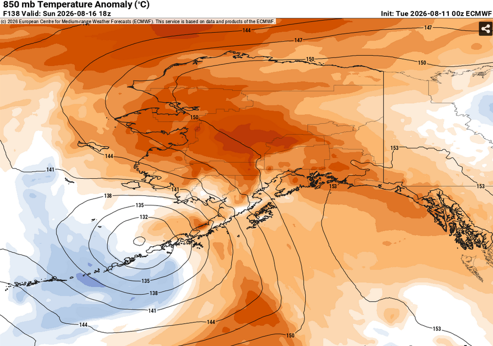
-

Occasional Thoughts on Climate Change
donsutherland1 replied to donsutherland1's topic in Climate Change
The Dust Bowl occupies an almost sacred place in the mythology of American climate-change denial. For decades, July 1936 was treated as something more than an old weather record. It was a relic. It was a supposedly untouchable reminder that extreme heat had happened long before modern greenhouse-gas concentrations reached today’s levels. Whenever evidence of warming accumulated, the response could be summoned: What about 1936? If the climate is warming, why hasn’t that record been broken? For ninety years, it wasn’t. Even July 2012 fell short. Then came July 2026. NOAA reported that July 2026 averaged 76.89°F across the contiguous United States, surpassing July 1936 and becoming the hottest month in the nation’s instrumental record. The seemingly unbreakable record had fallen. One monthly record does not prove climate change. Science does not rest on a single heat wave, drought, hurricane, or thermometer. The case for human-caused warming rests on something far larger: rising global temperatures, increasing ocean heat, retreating ice, rising seas, changing extremes, and the well-established physics of greenhouse gases. But the fall of July 1936 matters enormously as a symbol. For years, climate-change deniers used the endurance of that record as evidence that modern warming was exaggerated or nonexistent. Now the record they had elevated into an argument no longer supports them. And that creates a problem. If 1936 mattered when it stood unbeaten, it cannot suddenly become meaningless the moment it falls. The initial response from parts of the denial movement has been predictable. Denial, excuses, and insinuations that NOAA’s measurements somehow are not the “real” measurements. A CFACT policy analyst, for example, appealed to supposedly superior “real measured thermometer data.” But where is the analysis? Where is the methodology? Where is the reproducible evidence demonstrating that NOAA is wrong? Where is the paper with all that information? There is nothing. Just a hollow claim on social media. Without those things, “I have the real data” is not a scientific argument. It is an appeal to belief. It is a hallucination of an alternate reality that is as irrelevant to science as it is unreal. Science works differently. Produce the data. Explain the method. Show the calculations. Allow others to test them. If the evidence survives scrutiny, scientific understanding changes. Those rules may not hold in the policy world where ideology holds enormous power and interests influence thinking. But the scientific world is a whole different place. Pursuit of truth, even if that pursuit requires discarding earlier understanding, is of paramount importance. Ideological denial works in reverse of science. When evidence threatens the conclusion, the evidence itself becomes suspect. Beliefs, ideology, and interests must be defended, even at the cost of truth. The above rejection of the reality that July 2026 was hotter than July 1936 recalls opponents of Galileo who resisted observations that threatened the universe they already believed in. Rather than see for themselves through Galileo's telescope, the turned down his invitation. Sometimes it is easier to distrust the telescope than to rebuild one's understanding of the cosmos. To those timid souls, maintaining error is far more comforting than accepting that one's belief was wrong. Genuine courage gives one the strength to revise one's thinking when the evidence suggests such change is needed. The NOAA has confirmed that July 2026 is now the hottest month on record in the United States. A longstanding record has not merely been surpassed. One of the denial movement’s most durable rhetorical monuments has been toppled. Climate-change denial will not disappear because of a single record. New excuses will arise. Goalposts will be moved. But something important has changed. For ninety years, July 1936 stood as the great American heat record. It survived generation after generation. It survived 2012. It survived decades of rising greenhouse gas concentrations. Then, in July 2026, it fell. Science has no sacred records. It has evidence. 1936 was evidence. 2026 is evidence. The thermometer has now rendered its verdict. Pretense that it has not cannot affect reality. Pretense can only undermine the credibility of those who choose not to accept reality.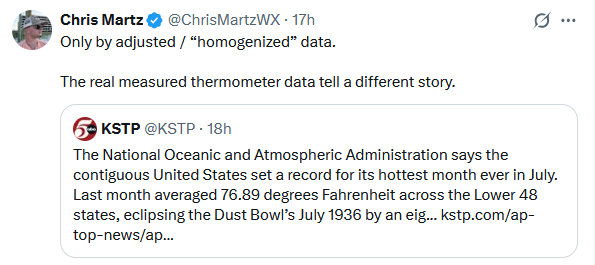
-
Thought I'd be waking up to some high-end garden variety stuff, but a pretty potent bow approaching I-70 now. Watch just issued that mentions scattered 80mph gusts, didn't think we'd get that until the afternoon
- Today
-
the way things are going - I would curb my enthusiasm for any significant cool down or lowering of humidity later in the week until its obvious it will actually verify
-
Records: Highs: EWR: 102 (1949) NYC: 102 (1944) LGA: 99 (1949) JFK: 99 (1949) Low: EWR: 56 (1972) NYC: 56 (1962) LGA: 57 (1962) JFK: 57 (1962) Historical: 1928: At 24th & M DC - Washington set a record of 7.31 inches of rain in 24 hours. East Coast Storms (Ref. AccWeather Weather History) 1933: The shade temperature reached 136.4° at San Luis, Mexico, to unofficially share the world record with Aziziyah, Lybia. (Ref. Wilson Wx. History) 1936: The warmest August temperature ever recorded in both Oklahoma City and Wichita Falls occurred on this date. The morning low in Oklahoma City was a warm 82°, before both cities warmed up to a very hot 113°. The old August record in Oklahoma City was 112, which was set the day before. In Wichita Falls, this record was tied on 8/6/1964. (Ref. Wilson Wx. History) 1940 - A Category 2 hurricane struck the Georgia and South Carolina coast. A 13-foot storm tide was measured along the South Carolina coast, while over 15 inches of rain fell across northern North Carolina. Significant flooding, the worst since 1607, and landslides struck Georgia, North Carolina, Tennessee, and Virginia during the system's slow trek as a weakening tropical storm, and then as an extratropical cyclone, through the Southeast. The landslides which struck North Carolina were considered a once in a century event. Damages relating to the storm totaled $13 million (1940 USD), and 50 people perished. 1944 - The temperature at Burlington, VT, soared to an all-time record high of 101 degrees. (The Weather Channel) The Dog Days officially come to an end on this date, having begun the third day in July. Superstition has it that dogs tend to become mad during that time of the year. (The Weather Channel) 1968: A young girl in a lake was injured when a dust devil near Bristol, CT carried a 150 pound roof covering a picnic area into a lake. (Ref. AccWeather Weather History) 1974: Illinois--Lightning struck and killed a boy who was hunting in Jersey County. (Ref. Lightning-The Underrated Killer.pdf) 1975: A line of heavy thunderstorms moved rapidly across portions of eastern South Dakota and into Iowa. In Canton, winds were estimated at 70 mph while the National Weather Service in Sioux Falls was belted with a 69 mph gust. The high winds leveled many trees and also destroyed some older buildings in Miner County while the Sioux Falls area had only tree damage and minor building damage. The storms maintained their strength as they moved into northwest Iowa. An uncompleted trucking terminal and several trucks received around $10,000 dollars in damage in Sac County while a grain storage bin was flattened and boat house destroyed near Storm Lake. (Ref. Wilson Wx. History) 1979: The mercury was plummeting over portions of the Arrowhead of Minnesota. The temperature at Embarrass, MN fell to 28°, accompanied by a hard freeze. (Ref. AccWeather Weather History) 1980 - Clouds and moisture from Hurricane Allen provided a brief break from the torrid Texas heatwave, with daily highs mostly in the 70s to lower 90s. (The Weather Channel) 1984: Dulles Airport records 11 inches of rain in 24 hrs. (Ref. Dulles Weather Records) (Ref. AccWeather Weather History) Miami, FL set a record high for the date with 96°. Then a thunderstorm cools things off to 70°, which set a record low for the date. (Ref. Wilson Wx. History) 1986: Atlanta, GA saw its streak of 38 consecutive days with 90 degrees or hotter finally come to an end with a reading of 89 °F. (Ref. AccWeather Weather History) 1987 - An early evening thunderstorm in Wyoming produced hail up to two inches in diameter from Alva to Hulett. Snow plows had to be used to clear Highway 24 south of Hulett, where hail formed drifts two feet deep. (The National Weather Summary) 1988 - Moisture from what remained of Tropical Storm Beryl resulted in torrential rains across eastern Texas. Twelve and a half inches of rain deluged Enterprise TX, which was more than the amount received there during the previous eight months. Philadelphia PA reported a record forty-four days of 90 degree weather for the year. Baltimore MD and Newark NJ reported a record fourteen straight days of 90 degree heat. (The National Weather Summary) 1989 - One of the most severe convective outbreaks of record came to a climax in southern California after four days. Thunderstorms deluged Benton CA with six inches of rain two days in a row, and the flooding which resulted caused more than a million dollars damage to homes and highways. Thunderstorms around Yellowstone Park WY produced four inches of rain in twenty minutes resulting in fifteen mudslides. Thunderstorms over Long Island NY drenched Suffolk County with 8 to 10 inches of rain. Twenty-three cities in the southeastern U.S. reported record low temperatures for the date. It was, for some cities, the fourth straight morning of record cold temperatures. (The National Weather Summary) (Storm Data) 1993: Ashley National Forest, Utah: A tornado strikes in the Uinta Mountains, 20 miles northeast of Roosevelt, Utah. It demolishes 1,000 acres of trees in the Ashley National Forest at 10,800 feet above sea level. (Ref. WxDoctor) 1999 - An F2 tornado touched down in the metropolitan area of Salt Lake City. The tornado lasted ten minutes and killed one person, injured more than 80 people, and caused more than $170 million in damages. It was the most destructive tornado in Utah's history and awakened the entire state's population to the fact that the Beehive State does experience tornadoes. 2001: A woman was struck and killed by lightning while on a boat in the Chesapeake Bay near the Oceanview section of Norfolk, VA. An Amherst, VA woman was struck by lightning and received minor injuries. (Ref. Lightning - Virginia Weather History) 2002: The National Weather Service at North Platte, NE reported huge 7 inch hail three miles east of Halsey, NE. (Ref. Wilson Wx. History) 2004: Wisconsin: A cold air mass descends over Wisconsin. Ten cities report maximum temperatures that are among the coldest ever for the month. Three break old records, two tie records and five record second lowest maximum temperature. High temperatures range from 52°F in the north to 59°F in southern part of the state. (Ref. WxDoctor) 2007: Dutch Harbor, AK set their all-time high temperature with a reading of 81°. (Ref. Wilson Wx. History) 2016: August 9-16. Weak low pressure combined with abundant Gulf moisture produced phenomenal rainfall and flooding across central Louisiana, inundating entire neighborhoods and towns, especially around Lafayette and Baton Rouge. Rainfall totals exceeded 20 inches in as little as two days. Thirteen people died and economic costs ranged from $10 to $15 billion.
-
I'm not sure I inherently "trust" any of the CAMs in setups like this. Even looking at all of them and taking an "average" can be off. I do think the HRRR (probably due to the fact that it's hourly) does tend to eventually latch onto something close to reality - but even then it can have times where it's sim reflectivity for 2 hours in the future doesn't even match reality. But yes - we shall see! Wouldn't be surprised if literally nothing happens locally today - but also wouldn't be surprised if there's a decent swath of 50-65mph wind across a good bit of the area.
- 1,863 replies
-
- 1
-

-
- severe
- thunderstorms
- (and 7 more)
-
I would like register a complaint about the weather. I very much like my forecasts but the weather itself has been most uncooperative.
-
76 / DP : 71, in / out of the clouds. Clouds were the caveat to extend this to a 6 day heatwave for some, and those clouds look to block the extension. Mid- upper 80s humid and scattered storms. Overall warm through Thu and thursday the next shot at 90 for the hotter locations before the cooler Fri - Sat / lower humidity arrive ahead of a brief surge of warmth Sun/Mon but that may be accompanied by rain/showers. Atlantic ridge shrinks inland ridge pops centered near Oklahoma much of next week with heat south of the area and temps riding near normal overall. Heast builds and pushes northeast between 8/19 - 8/23 with next shot at some heat. Beyond there overall warmer and watching the tropics.
-
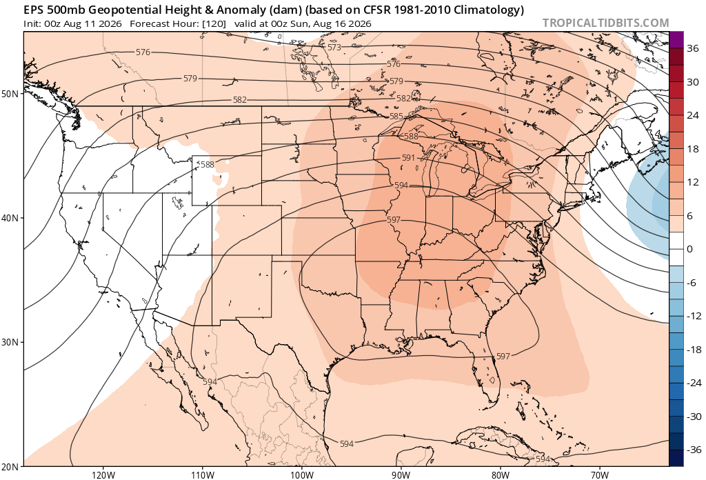
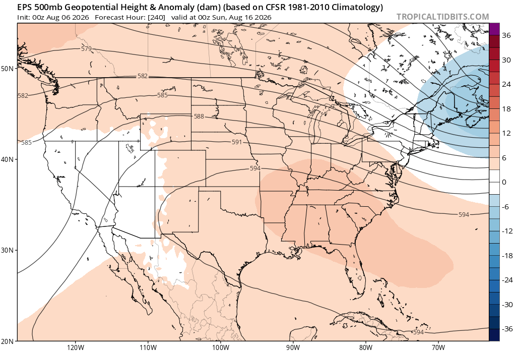
The ridge just doesn’t want to back down this summer. New run Old run
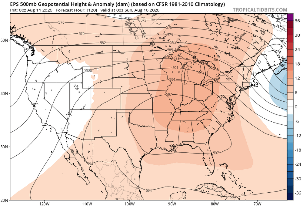
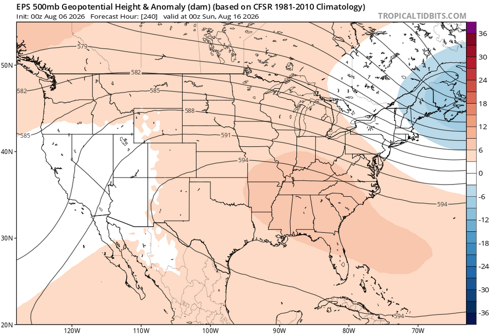
-
Some bright sun and blue skies here and off to the west. I think as long as we can get a good 4 to 6 hours of good heating it will be up to the boundaries and chance as you have stated
-
Using 1850 as a start point minimizes the damage. The global temperature trend goes downward until about 1917. If we used that as a start point, then the rise would be closer to +2C in ~110 years.










.thumb.jpg.ad3a2e31d30aff035044689b311a0540.jpg)