All Activity
- Past hour
-

Arctic Sea Ice Extent, Area, and Volume
Prismshine Productions replied to ORH_wxman's topic in Climate Change
Wtf happened here in Antarctica to lose over 300k... shelf calfing? Sent from my SM-S176V using Tapatalk -
DP's still 70 here
-

2026-2027 Record-breaking El Nino
40/70 Benchmark replied to Stormchaserchuck1's topic in Weather Forecasting and Discussion
Probably @Typhoon Tiplol -

2026-2027 Record-breaking El Nino
michsnowfreak replied to Stormchaserchuck1's topic in Weather Forecasting and Discussion
I believe that was the case in Feb 2015. I don't remember who, but someone had a meltdown with the historic cold because it was warm elsewhere in the globe, saying this is the worst thing for Americans who mock cc. -
2026-2027 Record-breaking El Nino
michsnowfreak replied to Stormchaserchuck1's topic in Weather Forecasting and Discussion
I thought i was reading backwards. "Poor guy" . HE was a complete dick, not the other way around. -
Sunday still looks like it has a chance. Maybe next Thursday too?
- 1,891 replies
-
- 1
-

-
- severe
- thunderstorms
- (and 7 more)
-
Raindrop is an excellent quick reference. I have been using it for probably 6 months. This radar indicated output can sometimes be a little too heavy compared to actual gauge measurement. My radar indicated data is probably different than yours, because my scan is near 13000 ft. I often compare radar vs. gauge measurement.
-
 https://mexisaferx.shop/# mexican pharmacys
 -
mexican mail order pharmacy and mexican pharmacy that ships to the us the purple pharmacy mexico http://www.leimbach-coaching.de/url?q=https://mexisaferx.com mexican pharmacy that ships to the us or http://clubdetenisalbatera.es/user/ffvynmqkta/ pharmacy in mexico [url=https://images.google.tn/url?sa=t&url=https://mexisaferx.com]pharmacys in mexico[/url] progreso, mexico pharmacy online or [url=https://www.0468wudi.com/home.php?mod=space&uid=246950]order meds from mexico[/url] the purple pharmacy mexico
-
Chicago NWS UPDATE... Issued at 1106 AM CDT Thu Aug 13 2026 Mosaic radar imagery shows a broad swath of rain showers moving east through Iowa and into southwestern Wisconsin and western Illinois. Notably, DVN radar shows a distinct curl from an MCV just south of Grandview as it crosses the Mississippi River. Recent mesoanalysis shows a low level instability gradient from Muscatine, IA to Fowler, IN. This remains the favored corridor that the system would likely want to travel along, and any storm movement east of this gradient in the forecast area would be expected to lose strength. Even as the complex loses strength over the area, stratiform rain is expected to spread over Illinois and northwest Indiana. Therefore, the forecast was adjusted to increase PoPs all the way up to the Wisconsin stateline through the afternoon for the increasing chances for widespread rain. However, the focused area for thunder remains southwest of Oregon to Morocco line. Wind shear is fairly marginal (localized up to 30 knots), but there is a stout DCAPE gradient from southern LaSalle to Benton County increasing southward to over 1000 J/kg. It will be this area that has the best probability for localized strong to potentially severe wind gusts, but confidence remains low.
-

Augdewst 2026: Summer's Last Stand
dendrite replied to Prismshine Productions's topic in New England
Someday the great drought will end.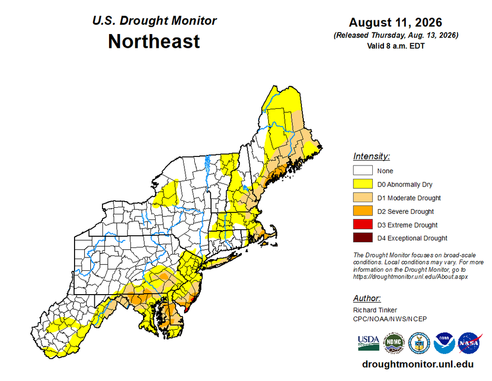
-
The U.S. Drought Monitor has been correcting weekly recently, gradually eliminating the Extreme Drought category in Virginia. This mornings update completely removes Extreme Drought from Augusta County. The 9 am version puts most of Augusta County in Severe Drought, with Moderate Drought west of Churchville and near Harriston. This is the first time in 2 months that the Monitor has been close to correct.
-
Yes, the ""tor psbl" tag gives a lot more leeway yet covers the threat just the same. It is a good "in-between" and works b/c now we know there are so many little spin-ups in SQLN situations. Some are very transient, but still can do damage. Then you have gustnadoes w/ can be up to EF1 strength, but do not count as tornadoes unless they connect to the cloud base, which often not easy to determine in the more moist environment and less visibility compared to the Plains.
-
JB’s top 6 analogs show what we’re facing. 3 has an HECS storm. The other 3 were snowless winters.
-
Ugh. How is this not getting more backlash? Seems to be a pretty big deal to me.
-
This Aug 1871 hurricane made landfall on the Big Island as an estimated Cat 3. Details analysis here: https://journals.ametsoc.org/view/journals/bams/99/1/bams-d-16-0333.1.xml
-
2 inches more than me. Of course the drought monitor says it has lessened.
-
2026-2027 Record-breaking El Nino
40/70 Benchmark replied to Stormchaserchuck1's topic in Weather Forecasting and Discussion
That JMA output is textbook Modoki composite. Again, I think that is overdone in the seasonal mean, but it is what it is. -
I sense we're incrementally inching closer, year by year, to the 'winter it didn't snow' Up N that's more likely just a shockingly low season total, but ranging to a phatty 0 at LGA and Logan. ORH got 1.5" of glop on January 7th and white pawed their way to more climate denial excuses. Sardonic aside, eventually that does have to happen. It'll be once ...then 5 years goes by, a span that host so-so's and one winter that is phenomenal, as much for snow as it will be enabling. Then, it happens again so soon? huh. Eventually ... they're happening more frequently and viola, "we're not Va Beach" This is a toad in the pan thing -
-

Invest 92L--80% two day, 80% five day odds
WxWatcher007 replied to WxWatcher007's topic in Tropical Headquarters
Pretty good chance we get TC genesis here. Gradual organization continuing. -
Wouldn't want to experience the damage the hail of this size creates. Thanks for posting!
-
Now that the follow up wave in the Tropical Atlantic has been designated as Invest 94L and has a decent chance of development, I'm breaking out discussion into a new thread. Eastern Tropical Atlantic (AL94): A tropical wave located a few hundred miles south-southwest of the Cabo Verde Islands is producing disorganized showers and thunderstorms. Environmental conditions are forecast to be generally conducive for gradual development, and a tropical depression could form late this week or this weekend while the wave moves westward or west-northwestward across the eastern and central tropical Atlantic. * Formation chance through 48 hours...low...30 percent. * Formation chance through 7 days...medium...50 percent.
-
Had nice storm around 2am. Got 1/4" of rain. Warm out but a cool breeze making things tolerable.
-

Augdewst 2026: Summer's Last Stand
weatherwiz replied to Prismshine Productions's topic in New England
I am really starting to wonder if a brief tornado touchdown between Milford/Orange and then touched down again around Lighthouse Point. We'll have to see if the NWS sends out anyone to survey. - Today
-
Very localized. Only damage seems to be Lighthouse point and the area that says woodmont on your radar screenshot.