All Activity
- Past hour
-
53 degrees with steady light rain. Nasty.
-
The little ice age has come back.
-
I already expect to have the oven on a couple times to take the edge off.
-
.07" today so far. Should be a quiet mid day until that from rolls back north and lets the humidity into the region then some storms should fire up later on this afternoon/evening. 59* currently
-
2.52 and climbing
-
Event total up to 3" on the nose. Temp steady @ 49.
-
53F right now. Chilly with the breeze
-
Can you expand these to 3 days (Saturday, Sunday, and Monday), so I can see the whole picture for the entire Memorial Day weekends? For example, 2021 at 72 and 0.00 rain looks misleading because you had highs in the 50s (probably record low maxes) and a lot of rain on Saturday and Sunday.
-
Looks like all the models give us another .5-2 inches of rain beyond this current system. CMC and GFS have it mainly fall on Monday-Tuesday with it's specific disturbance while Euro focuses it more with Thursday.
-
Opening swim team event 50 degrees and pouring lol
-
I know, quite the flip possible. Its pretty nice here now. 66/37
-
I’m hoping I don’t have to turn the heat on tomorrow.
-
Columbia/I had 3” for event total as of this morning. Another .2” or so in last 4 hours.
-
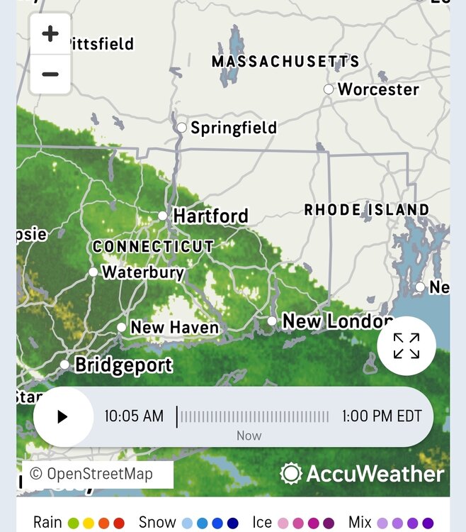
Over 2 inches now for the total, and still raining.
-
.75 today and 1.87 so far. That might be a little light. Had to clean the opening of the rain gauge after some of the rain Thursday.
-

E PA/NJ/DE Spring 2026 Obs/Discussion
Albedoman replied to PhiEaglesfan712's topic in Philadelphia Region
I had to work during the heat wave and simply did not have the luxury of spending hours challenging or debating data records online. However, in nearly 40 years of living here, I can honestly say this appears to be one of the coldest stretches heading into this time of year that I can remember locally. The long-range guidance continues hinting at that pattern as well, with some overnight lows potentially dropping into the lower 40s over the next few weeks. As a Township Manager, my responsibilities come first. Between preparing for potential EOC-related security concerns surrounding the election with the bombing and handling day-to-day municipal operations throughout the Lehigh Valley on Tuesday, I simply did not have the opportunity to post. Yes, the recent heat wave was unusual, but that is also consistent with the current atmospheric setup. In this pattern, the low-pressure systems are often getting cut off before fully reaching our area, which can temporarily allow short bursts of abnormal warmth before the larger-scale cooler regime reestablishes itself. -
It is FANTASTIC yardwork weather!!!
-
It is good yardwork weather.
-
there would be some meltdowns if it were winter
- Today
-
Enjoy!
-
So glad we don't live there.
-
since it did not rain as expected i did my walk it felt like a thanksgiving types of day raw windy chilly i even sneezed a few times i hope i do not catch a cold.
-

Mid-Long Range Discussion 2026
WinstonSalemArlington replied to BooneWX's topic in Southeastern States
Omega Block? -
Hey Steve, IMO it’s not needed because: -An ATL trop. thread already exists each year, with a big increase in posts when the SE is threatened: -When there are specific storm threats to the SE, I’ve started threads on those storms in SE region and probably would again if nobody else does. But even then, there were more posts in the main thread as tropical posts here were kind of limited. -So, I don't think a 2nd general trop thread is needed here. I suggest posting in the general thread and then also in any individual storm SE threat if they’re created.
-
Good to see a lot of folks doing well with the rain. Up to 1.45 here.


.thumb.gif.f92b16c631a1d15d405ed77b33f0710d.gif)


