All Activity
- Past hour
-

The “I bring the mojo” Jan 30-Feb 1 potential winter storm
Regan replied to lilj4425's topic in Southeastern States
Maybe I’m wrong but he’s not showing a “dry slot” over central Nc. At least as extreme as some. Even Allan, he’s got the big numbers but I disclaimer in C zone that it could happen. As said prior, he sees at least 2-3 (if there’s a slot) in Raleigh per an exchange with someone on x. -

Possible coastal storm centered on Feb 1 2026.
SouthCoastMA replied to Typhoon Tip's topic in New England
NAM looked decent at 48h..but extrapolating this model past that is asking for trouble. -
I want to call out weird behavior from accuweather. they virtually ignored the storm last week until it was right on our doorstep and then they went with the under in terms of accumulation. This week they are all over this storm and bullish. Immediately put out 1 to 3 inches several days out and with model uncertainty. Just odd
-

The “I bring the mojo” Jan 30-Feb 1 potential winter storm
BooneWX replied to lilj4425's topic in Southeastern States
After last week’s public outrage that was totally misdirected towards him, I can’t blame him at all. He could come out and give you his boom scenario, but would that really benefit him? If he forecasts 2-5” and you get 10”, nobody is going to scream. Now if he says 10” and you get 9”, people will bring pitchforks. -
12z NAM starts the show at 1600 tomorrow in Knox. Most other models start around 1900 FWIW.
-

The “I bring the mojo” Jan 30-Feb 1 potential winter storm
Buddy1987 replied to lilj4425's topic in Southeastern States
The vort at 45 is noticeably better and digging quite a bit more, with heights rising in New England. This is how someone away from the coastal influence scores a major coup. You can see precip expanding into the foothills, s va and from about Greensboro north. -
The Mount Holly discussion is dated 2 days earlier than the NYC discussion...
-
 NAM digging that vort a bit more west lolololol, couldn’t help myself
 -

Possible coastal storm centered on Feb 1 2026.
WinterWolf replied to Typhoon Tip's topic in New England
Hmmm…I wonder why? -

Possible coastal storm centered on Feb 1 2026.
gonegalt replied to Typhoon Tip's topic in New England
StabbyStab is on antifa assignment in Minneapolis. -

Winter cancelled/uncancelled banter 25/26
Stormlover74 replied to Rjay's topic in New York City Metro
Because of the 10 day thaw January will be below but not close to one of the coldest overall. Impressive stretch we're in now of course -
May have to watch late next week.
-

Possible coastal storm centered on Feb 1 2026.
Typhoon Tip replied to Typhoon Tip's topic in New England
Mathematically ... the speed of the flow is absolutely a part and crucial part at that, in the Navier-Stokes momentum of fluid system equations, to which these models are physically responsible for. Propagating a wave through that medium is effected - There may also be other factors involved; I'll just add that I've seen 500 mb progression of Feb 5 1978, and the block decaying was observed as collapsing S - it was in fact what triggers the N/stream to fall S/ subsume scenario. But maybe I don't know what you mean? -

The “I bring the mojo” Jan 30-Feb 1 potential winter storm
KyleEverett replied to lilj4425's topic in Southeastern States
Brad not believing in the Charlotte and upstate wins scenarios breaks my heart. -

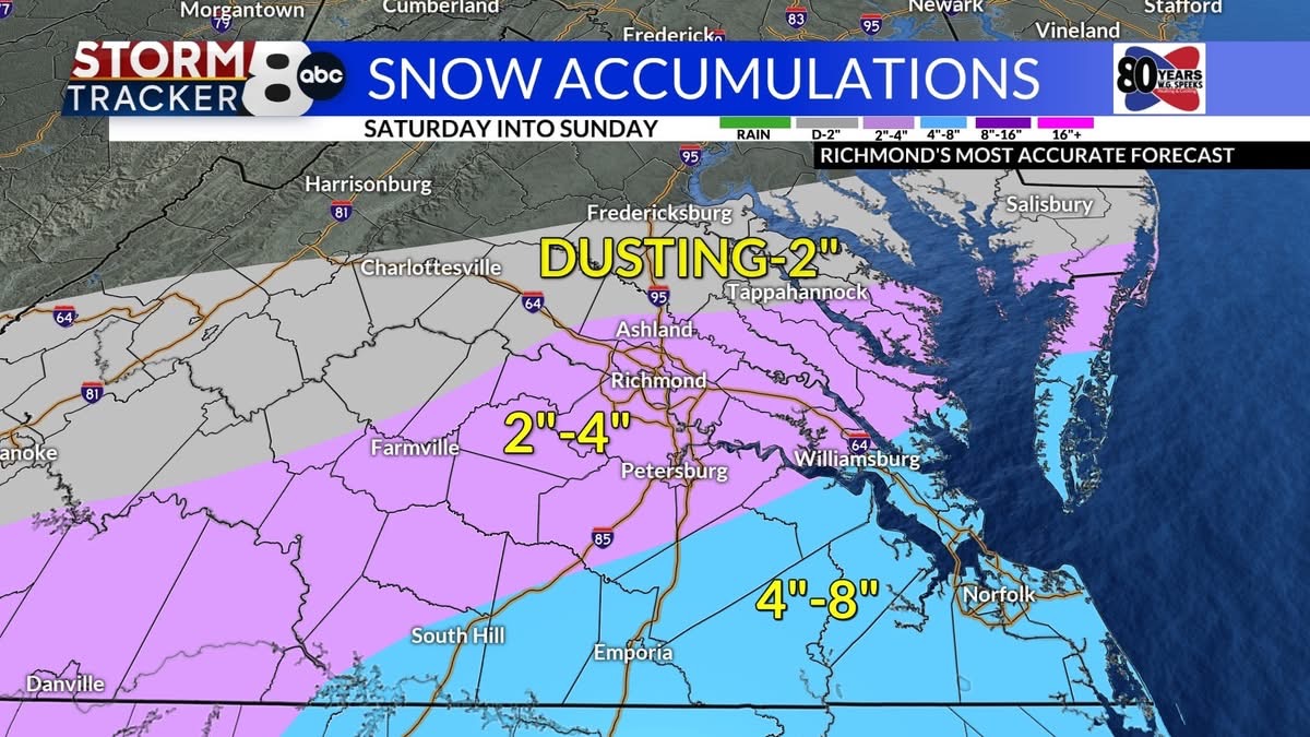
Richmond Metro/Hampton Roads Area Discussion
RVASnowLover replied to RIC Airport's topic in Mid Atlantic
-

Richmond Metro/Hampton Roads Area Discussion
Ephesians2 replied to RIC Airport's topic in Mid Atlantic
12z NAM looks better at 500mb at 45h. West of both 00z and 06z and a tad less confluence -
Possible coastal storm centered on Feb 1 2026.
WinterWolf replied to Typhoon Tip's topic in New England
He’s a complete idiot. -
Only down to 7 this morning here. I don't radiate well here
-

Central PA Winter 25/26 Discussion and Obs
Itstrainingtime replied to MAG5035's topic in Upstate New York/Pennsylvania
I wasn't going to say this but since you sort of baited me, I will - I'm being completely honest...it "felt" colder in Florida both when I arrived back on the 18th and when I left on the 27th. The combination of temps in the 30s with sustained 20+mph winds and the cold down there is different...it's not as dry down there so it actually feels colder than it does up here. When I was in Jacksonville on Tuesday morning the real feel was 12. It was really, really cold. On the flip side, there were several days last week when it was hot. Mid to high 80s temps with low 70s dewpoints. So I really had a chance to experience the best and worst of Florida's climate in one single trip. Really fascinating how it all went down. I'll add that I'm happy to be home. My trip was an entirely solo trip. (my wife and I are perfectly fine ) I was doing some scouting/research for some opportunities I'm investing in as I transition into retirement in the next several years. I'll share more when it's appropriate. -
The “I bring the mojo” Jan 30-Feb 1 potential winter storm
Buddy1987 replied to lilj4425's topic in Southeastern States
DEF 3K as it gets into range. -
The “I bring the mojo” Jan 30-Feb 1 potential winter storm
Buddy1987 replied to lilj4425's topic in Southeastern States
NAM at 39 has a very healthy ribbon of snow, more so than 6Z, breaking out over eastern KY, nw TN and into S VA. -
I've seen Metrolina get blanked in so many Low energy transfers that I still expect it to happen. If somehow this is the one time Charlotte wins while RDU loses, I think it's fair though! Though Brad P just posted his call map and it's time to cliff dive cause he doesn't believe in the Upstate/Metrolina jackpots.
-
Yeah something usually goes wrong. But I think it's always been like that to a large degree. It's why NYC rarely exceeded 80" in a winter even dating back 100+ years and during a colder climate. We just didn't used to so carefully monitor from 10 days out on a dozen different models every 6 hours. It was convoluted in the past too but we just didn't notice.
-

Southern MD / Lower Eastern Shore weather discussion
PrinceFrederickWx replied to PrinceFrederickWx's topic in Mid Atlantic
-
"Red sky at night, sailors delight; red sky in morning, sailors take warning - a winter storm warning!"