All Activity
- Past hour
-
 What sticks out for me relates to a broader topic... That's a pretty classic tripolar anomaly distribution, which is correlated well with -NAO Now, at a 50, 000 foot linear correlation the -NAO is typically found during EC cane threats. The reason can actually be summed up in one sentence: -NAO means blocking at higher latitudes and that prevents a Bahama routed cane from turn NE early. Up they come... But there's a caveat emptor: ...the NAO is not persistent at seasonal scale. So, having the tripole may mean there's a propensity for waxing and waning of the negative mode. If one is a cane/denudation of LI enthusiast ... replete with all the sociopathic wanton of calamity ... ( LOL ), you at least have increased potential for a favorable super synoptic implication.
 -
Storms moving weird again today. Generally E-W in the Central Valley whilst storms along the southern valley are moving S-N. Very cool to watch on radar. .
-
Pretty awful short term forecast model bust today…have seen the sun for maybe 10 mins.
-

2026-2027 Super El Nino
GaWx replied to Stormchaserchuck1's topic in Weather Forecasting and Discussion
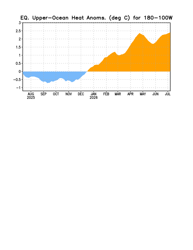
We’re probably heading to a new warmest OHC of this Nino per this (often the far right portion of these graphs is later revised due to interpolation…so it isn’t certain yet):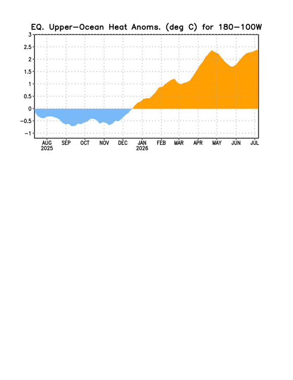
-
NAM tries to leak some moisture in to the area up under the ridge late week setting off some garden variety, something to watch as we torch under full sun for most the week
-

E PA/NJ/DE Summer 2026 Obs/Discussion
nesussxwx1 replied to PhiEaglesfan712's topic in Philadelphia Region
Great time lapse Basile! -
 Sept 1821 redux for the north? https://en.wikipedia.org/wiki/September_1821_New_England_tornado_outbreak
 -
E PA/NJ/DE Summer 2026 Obs/Discussion
nesussxwx1 replied to PhiEaglesfan712's topic in Philadelphia Region
-

Central PA Summer 2026 Discussion/Obs Thread
canderson replied to Voyager's topic in Upstate New York/Pennsylvania
And then the ground truth is a dusting -

2026-2027 Super El Nino
snowman19 replied to Stormchaserchuck1's topic in Weather Forecasting and Discussion
Agreed. -
Monday morning low IMBY/Columbia 65° (compared to BWI 63°)
-
2026-2027 Super El Nino
GaWx replied to Stormchaserchuck1's topic in Weather Forecasting and Discussion
Thanks, Adam. It appears that Zeke’s using ONI based climo comparisons. If he were to instead use RONI, it would still be the warmest on record but not by as much as the 0.8C that he refers to. So, it would be an easy record breaker even by RONI standards. -
I like seeing the GDM (Google Deep Mind) ensembles increasingly bullish on some type of development. I'm intrigued. 3/10 for now.
-
I would happily sacrifice and have a generally mild winter if we could just time one huge storm with a cold enough airmass. We are going on 11 years since the last legitimate snowstorm(around Baltimore at least.) I don’t know about anyone else, but despite the storm that ended up becoming a sleet bomb last winter, the first few hours it was the only time since January 2016 that it felt and looked like a real snowstorm. Been chasing that feeling for 10 years. Sucks that it couldn’t stay pure snow, but it reminded me of how that feels. I love the cold weather as much as anyone, but we need to take our chances with above average precipitation. I know “We’re due” isn’t scientific, but at some point 11 years into it…
-
Mostly misses down here. My 3 day total sits at 0.71", but it came in 4-5 different brief showers. Good for the grass, not so great for ponds and streams which are all VERY low. Looks like coverage will be better down here today and tomorrow.
-
 I have no doubt that if we saw a repeat of 1938 in terms of track and intensity, people would take it seriously. Keep in mind, to get a major here you probably need it to be a high end 3 or more likely, Cat 4 off the NC coast (as 1938 was) and that alone would have people in a panic. It'd be the most hyped storm in history, with good reason. A bona fide major would be catastrophic depending on the track, even absent C3 sustained winds inland (which would be unlikely unless this is rocketing). Now that said, on this board? I already know how the run up would be. The first time the Euro kicks it at 144 with an over-zealous trough "she gone" would be the most popular phrase on the board. Followed by days and days of downplaying. Then complaining over the final track, which will shift 50 miles in the last 12 hours. Haven't seen a C5 yet, but I've seen a couple 4s, it's incredible. In Helene, I regret not doing a U-Turn on the highway to get a photo but I saw a massive pine snapped at the base well inland. In Laura, the damage was staggering. Fiona--it wasn't officially a hurricane when it hit Nova Scotia but I was one of the first on the ground after it passed and produced that 97kt gust in Arisaig. The damage was incredible all the way back to New Brunswick. But folks should know that even lower end tropical can and will do big time damage. The October Cape Cod crusher a few years ago (eventually Wanda) did C1 damage through the region and it was big time. I'm not as bearish as I was a few weeks ago. Subtropics aren't as bad thermodynamically as they could be. But the wind shear and dry air with more frequent troughs later in the season will be an issue. The window is narrow, but probably the place where we're most likely to see activity. Doubt anything meaningful comes out of the MDR this year.
 -
 May end up being one of the best light shows you can possibly ask for around these parts 6z NAM bufkit had >1000 J of CAPE in the -10C to -30C layer with > 3000 MUCAPE, that's nuts for this region
 -
Yeah, the wording does sound kind of funny. Obviously, nobody can ever say what the hottest, coldest, etc. of all time/ever is in any location since that can’t possibly be known. But saying something is an “all-time record” in a location is, of course, totally different and is what the NWS is referring to. Now I’m going to get more technical: whereas one can’t possibly know the hottest or coldest ever in a location, they can know the hottest or coldest ever in a city (I’m saying “city” not “location”) if records have been kept since the city’s founding. Do you see the difference?
-
90/75 and as still as can be.
-
 I'll be in the Ogunquit / Wells area... What are you thinking? Might be able to see great light show off to the north?
 -
2026-2027 Super El Nino
snowman19 replied to Stormchaserchuck1's topic in Weather Forecasting and Discussion
-

Central PA Summer 2026 Discussion/Obs Thread
mahantango#1 replied to Voyager's topic in Upstate New York/Pennsylvania
It's the element of surprise. Just like winter snowstorms you go to bed feeling confident that NWS has an advisory out for 1 to 3 in of snow tomorrow. But you wake up tomorrow morning and it's a winter storm warning for 10 to 14 inches. -
These little passing showers are annoying
- Today
-
E PA/NJ/DE Summer 2026 Obs/Discussion
nesussxwx1 replied to PhiEaglesfan712's topic in Philadelphia Region
Was busy this weekend so wasn't able to send updates but the storm on Saturday was one of the worst I've seen in a long time. Was stranded on 295-S near Deptford, had to pull over. Hope everyone is safe. Best, -
Uggh…This summer is almost as painful as most of last winter in regards to storms. Jesus…Even for a typical non severe summer it has been frustratingly quiet. Of course not the case W/S/N of us. Even saw some grow over the ocean east of us once. Ok. Rant over