All Activity
- Past hour
-
Theme of the winter now you see it now you don’t. It’s all IVT and OE other than the one big storm
-
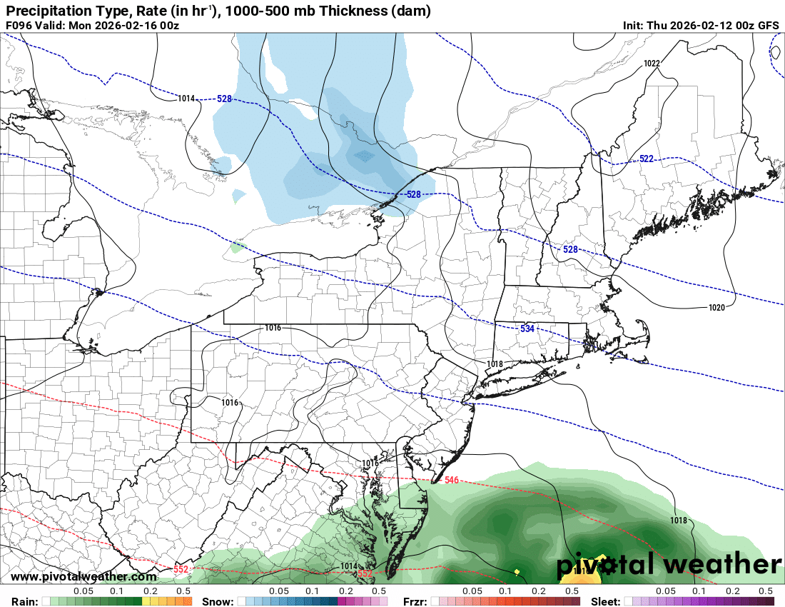
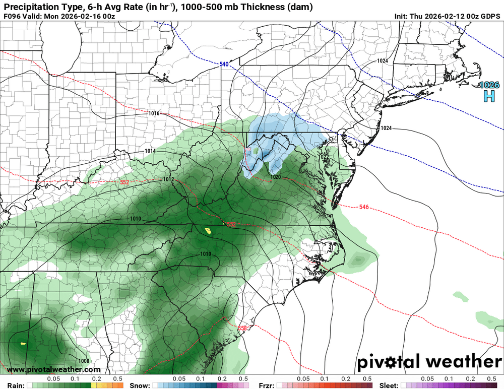
It would have to come back on the Euro for pinnage. Now we are tracking light rain withbthe chance if moderate rain.
-
Did the GFS come out already?
-
Storm is done Euro is a terrible model
-
What a waste
-
I doubt this since the WPO will become negative again. Take the weeklies with a grain of salt.
-
We can’t even get this thing pinned. What a disgrace.
-

Central PA Winter 25/26 Discussion and Obs
Itstrainingtime replied to MAG5035's topic in Upstate New York/Pennsylvania
Some models indicate warmer than that. 70s up into central MD. -

Is we back? February discussion thread
40/70 Benchmark replied to mahk_webstah's topic in New England
Tell it to join the club. -
-

Central PA Winter 25/26 Discussion and Obs
canderson replied to MAG5035's topic in Upstate New York/Pennsylvania
50s are possible middle of next week I’m still holding out hope for rain Sunday to wash salt away but decent precip seems …. Skeptical -
The March 2022 snow was a Miller A, just timed up perfectly with a cold shot. We were in the 70s a few days before it arrived.
-
lol keeps going south…. Can’t even get rain. What a crappy pattern

-
My biggest snow here was in January 2024... my second biggest was March 2022. Do you remember the setup? I think it was a bowling ball ULL that dropped down from the north, but I remember it being very mild the day before, snowing extremely heavily overnight and into the morning hours, and ending with 6.5 inches. Quickly melted away in the afternoon sun and the next day as it warmed up again, but an exciting storm of a magnitude I never thought I'd experience in Knoxville again (until January 2024 came around that is). But I definitely never write off March after that, even if the odds are low
-
 From Wikipedia: “In Toamasina, where Gezani made landfall, buildings and walls collapsed, power poles and trees were downed, and roofs were blown off buildings.[41] At least 20 deaths, 15 missing and 33 injuries were recorded, with over 3,200 homes damaged or destroyed and 2,742 people displaced.[42] Malagasy president Michael Randrianirina said 75% of Toamasina had been destroyed by the storm.” :(
 -

Is we back? February discussion thread
Prismshine Productions replied to mahk_webstah's topic in New England
Icon says what storm Sent from my SM-S166V using Tapatalk -

Feb 10-11 Mid Week Minor Event - Ride the hot hand?
rimetree replied to HoarfrostHubb's topic in New England
Got 5.75" from this with a little coating on top from squalls earlier. Snow blower struggled a bit with the heft of this snow unlike most of the events this season. Actually not far from a normal season at this point. -
The 18z EPS-AIFS are very snowy, which is suspicious. A few of the individuals continue to show a high end snowstorm, which skews the mean, but even the median is decent for snow. It's strange considering how far off most guidance looks in the upper levels from supporting a coastal SLP. It looks like there is a lot of sensitivity with respect to phasing of the northern stream. And a small amount of phasing could lead to a significant surface response.
-

Anyone having trouble paying the subscription?
VAsnowfan replied to MN Transplant's topic in Forum Information & Help
Same thing happened to me just now. -
Winter 2025-2026 Offers Return to Normalcy
40/70 Benchmark replied to 40/70 Benchmark's topic in New England
Verification of Messy Tuesday Evening Forecast Strong Effort Here is the Eastern Mass Weather forecast issued on Monday valid for last night's minor event. The forecast overall was very accurate, although there were a few amounts that narrowly exceeded the 1-3" range over the northern portion of the forecast, it was by a very small margin and they were few and far between. The outlier 6" report from Gloucester, MA is dismissed as being highly suspect. Final Grade: A -

February 2026 OBS & Discussion
PhiEaglesfan712 replied to Stormlover74's topic in New York City Metro
Also March is going to start out in MJO Phase 6. Good luck trying to get a cold/snowy pattern out of that. -
First day above 40 since the mild up in early January. Still above freezing at 10:45pm. Currently 34 IMBY. The melting continues.
-
Feb 10-11 Mid Week Minor Event - Ride the hot hand?
40/70 Benchmark replied to HoarfrostHubb's topic in New England
Strong Forecast for last night. Grade that one an "A". https://easternmassweather.blogspot.com/.../verification... Storm potential for Monday remains very dubious. Here is the Eastern Mass Weather forecast issued on Monday valid for last night's minor event. - Today
-
Same ole Clemson team year in and year out in basketball. Always gives their fans false hope but it shouldn't. Look at their schedule every year and see who they have played. It should be no surprise but I will be a Clemson fan when they play the holes in chapel hole.
-
 So we know who to sacrifice when it doesn’t snow