All Activity
- Past hour
-

2026-2027 Record-breaking El Nino
GaWx replied to Stormchaserchuck1's topic in Weather Forecasting and Discussion
In the 1980s soon after obtaining my first job in my field of study, my first big purchase was for a washer/dryer. I was so excited. But I was even more excited with my 2nd buy, an even bigger one: what my friends called a “weather machine”. This “machine” was a combo of the following: a pretty high end short wave radio to get radio facsimile sounds, a dot matrix B/W printer, and a radio facsimile decoder that was sent to me from England. This was a dream come true. -
August 14 1978: The Boundary Waters area is hit by a strong tornado. Some of the damage could still be seen 10 years later. For Friday, August 14, 2026 1898 - A deadly, estimated F4 tornado moved southeast from 12 miles northwest of Clear Lake, South Dakota, passing 7 miles north of town and ending about 4 miles west of Gary. Deaths occurred on two farms. One man was killed when the kitchen of his farm house was torn off. Five members of one family were killed along with two labors on another farm as every building was swept away. Buildings suffered massive damage on eight farms. This tornado was one of the earliest, estimated F4 tornadoes on record for South Dakota. 1936 - Temperatures across much of eastern Kansas soared above 110 degrees. Kansas City MO hit an all-time record high of 113 degrees. It was one of sixteen consecutive days of 100 degree heat for Kansas City. During that summer there were a record 53 days of 100 degree heat, and during the three summer months Kansas City received just 1.12 inches of rain. (The Kansas City Weather Almanac) 1953 - Hurricane Barbara hits North Carolina as a Category 2 hurricane. Damage from the storm was relatively minor, totaling around $1.3 million (1953 USD). Most of it occurred in North Carolina and Virginia from crop damage. The hurricane left several injuries, some traffic accidents, as well as seven fatalities in the eastern United States; at least two were due to electrocution from downed power lines. Offshore Atlantic Canada, a small boat sunk, killing its crew of two. 1987 - Slow moving thunderstorms deluged northern and western suburbs of Chicago IL with torrential rains. O'Hare Airport reported 9.35 inches in 18 hours, easily exceeding the previous 24 hour record of 6.24 inches. Flooding over a five day period resulted in 221 million dollars damage. It was Chicago's worst flash flood event, particularly for northern and western sections of the city. Kennedy Expressway became a footpath for thousands of travelers to O'Hare Airport as roads were closed. The heavy rains swelled the Des Plaines River above flood stage, and many persons had to be rescued from stalled vehicles on flooded roads. (13th- 14th) (The National Weather Summary) (Storm Data) (The Weather Channel) 1988 - Eighteen cities in the northeastern U.S. reported record high temperatures for the date, and the water temperature at Lake Erie reached a record 80 degrees. Portland ME reported a record fourteen straight days of 80 degree weather. Milwaukee WI reported a record 34 days of 90 degree heat for the year. Afternoon and evening thunderstorms resulted in about fifty reports of severe weather in the northeastern U.S. One person was killed at Stockbridge MI when a tornado knocked a tree onto their camper. (The National Weather Summary) (Storm Data) 1989 - Afternoon thunderstorms in Illinois soaked the town of Battendorf with 2.10 inches of rain in thirty minutes. Evening thunderstorms in Montana produced wind gusts to 66 mph at Hobson. (The National Weather Summary) (Storm Data) Observances: 14 Fri World Lizard Day 14 Fri Social Security Act 14 Fri National Financial Awareness Day 14 Fri National Creamsicle Day 14 Fri National Spirit of ’45 Day 14 Fri National Tattoo Removal Day 14 Fri Navajo Code Talkers Day 14 Fri Vigil of Assumption Day
-
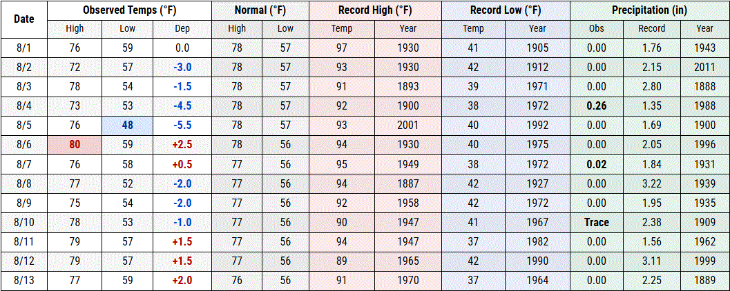
Seasonable Aug so far, but dry. Avg's on the downturn. DLH TH
-
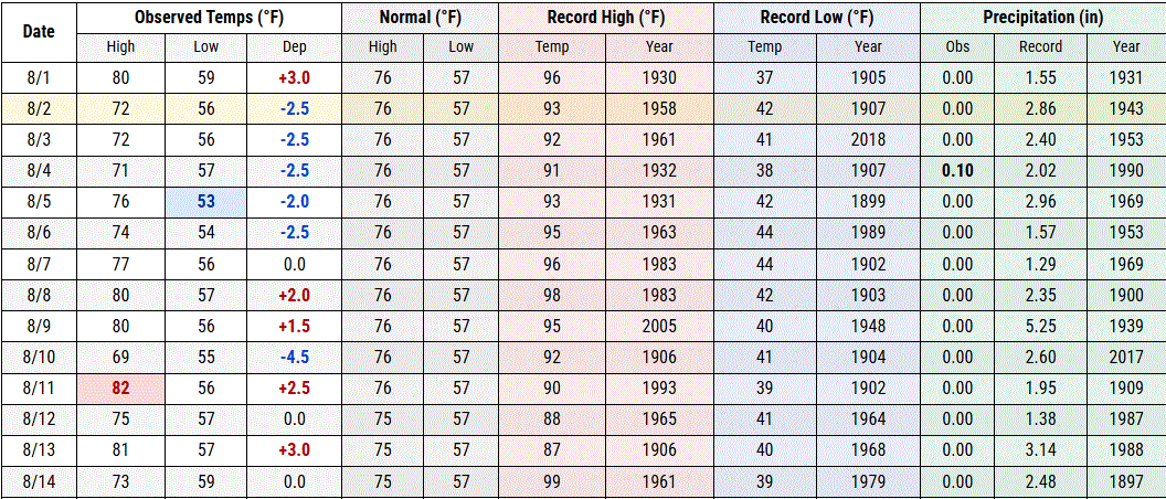
Wasn't expecting rain today but I'll take it!
-

2026-2027 Record-breaking El Nino
bluewave replied to Stormchaserchuck1's topic in Weather Forecasting and Discussion
It’s also a challenge when you aren’t speaking with someone in person. Many not written cues can get lost on these forums. I am sure if we all met in person things would be different. Also goes to how many interactions these days occur online vs in person prior to social media and the internet. So we don’t have the benefit of nonverbal cues which are common in actual life. Even with all of issues that pop up from time to on these forums, the benefits outweigh any negatives. Weather models and past statistics for various stations used to be very limited before the age of the internet. I can remember the old Alden Difax machines that was the only way to get weather models. Plus there were no freely available databases containing past reanalysis products with 500 mb patterns and temperatures for any given month or period. -
Lows in the 40's with some 50's this morning. Cool, but we are heading into early Fall. In a couple weeks, the threat of widespread frost looms.
-
It's tough, but you just have to keep pushing them. AI and social media sites have made finding a job extremely difficulty when first starting out. In most cases, you have to know someone to get even an interview.
-
 Models really backed off this one too.
 -
Invest 92L--20% two day, 20% five day odds
WxWatcher007 replied to WxWatcher007's topic in Tropical Headquarters
Sacrificial wave it seems. -
Augdewst 2026: Summer's Last Stand
WxWatcher007 replied to Prismshine Productions's topic in New England
Dumb question, but radial velocity? -

Central PA Summer 2026 Discussion/Obs Thread
Itstrainingtime replied to Voyager's topic in Upstate New York/Pennsylvania
I will laugh myself silly if Drew Allar keeps doing what he did last night. I hope he quiets all the naysayers. I've been a huge fan since day 1. PSU screwed him royally. -
2026-2027 Record-breaking El Nino
GaWx replied to Stormchaserchuck1's topic in Weather Forecasting and Discussion
Vigorous but respectful discussion/debate about the relevant subject makes for the best threads. Echo chambers are boring. It’s beneficial to respectfully debate alternative viewpoints. Intense debates relying on factual evidence, critical thinking, and sound reasoning instead of emotional appeals or personal attacks are the most desirable. Also, being open-minded to change one’s views is beneficial to these threads. Posters displaying intellectual humility, reading others’ posts thoroughly, and being willing to update their views when presented with better evidence is desirable for quality threads. @bluewave Edit: Many of the worst threads at this BB were in the Politics forum because little of the above was the case in most threads. Hardly anyone was open minded about anything and personal attacks were common. Trolling was common. It was absolutely awful due to hardly any intelligent debate. Fortunately, this thread is far better! -
My social media feed seems to be littered with gender war crap, including people celebrating walking out on their spouse just because they weren't totally happy. It's not men or women, it's both... women proudly posting about how they left just because they felt bored or something "just wasn't right" and men bragging they left because their wife wasn't... well use your imagination here. WTF is going on? Forget the battle of the sexes crap, when did marriage vows become a total joke? I mean... there are legit reasons to leave a marriage. Abuse. And I include emotional abuse not just physical. But I don't ever remember the "until I get bored or you're not putting out enough" clause in the "until death do us part" portion of the wedding! Did I miss some major announcement where marriage vows were just a suggestion and no longer an actual commitment?
-
 https://mapletrustrx.shop/# best canadian online pharmacy reviews
 -
Warm and muggy vs cool and dry. I’ll take the cool temps but would have loved to have seen some of that rain and storms even tho Marquette county isn’t too terribly dry but other spots are. Looking forward to a wild autumn and winter, warm or cold.
-
It's possible, but the history on super Nino's would imply the last likely outcome is that "in between" scenario. The key is going to be the exact location of two features. The North Pac low and the AO/NAO high/block. These two features showed up in almost all the analogs. But there is a balancing act on how they play off each other. The further east the Pac low is the worse it is for us. The further southwest the NAO/AO high is...for instance if it ends up centered over Quebec instead of truly in the NAO domain...the worse.. about half the super nino's that combo ended up toxic...the PAC low too far east blasting pac puke across the whole continent all winter...and the AO/NAO high too far southwest so that it didn't help block down even domestic cold from canada but instead just "blocked" the pac puke over the lower 48 all winter...and in those winters it was simply mild and wet all winter. The more favorable winters, that combo was more favorable, enough so that we were able to get some windows and cash in on one or two of the STJ waves for a huge snowstorm. There weren't many examples of in between. 2024 maybe but that was a really odd winter where a strong nino never acted like it and I don't expect that to happen again give the combo of how strong this is and the PDO seeming to be coming off the peak of its cycle.
-
Someone could make $ them making this available for a fee. I’d use it. But then again I’m weird so maybe there isn’t much demand.
-
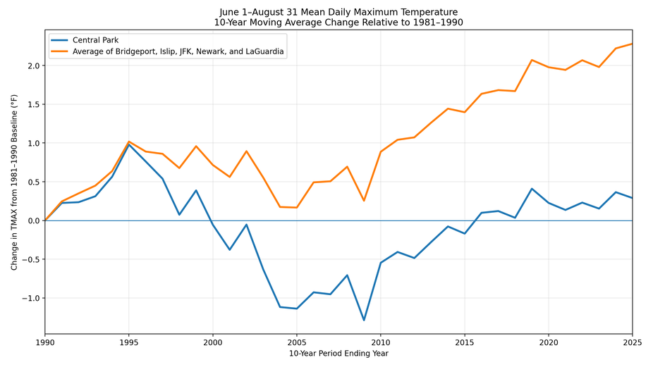
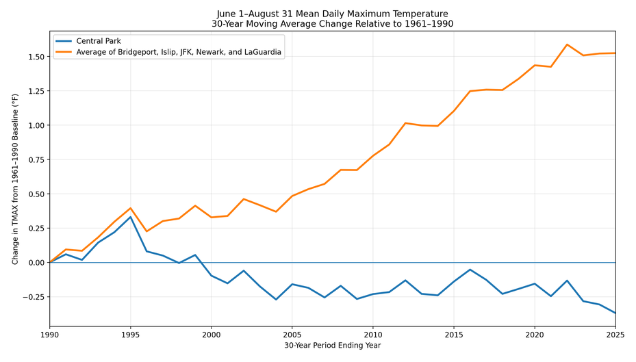
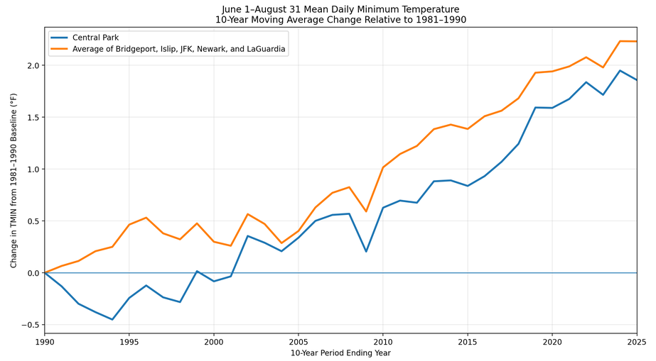
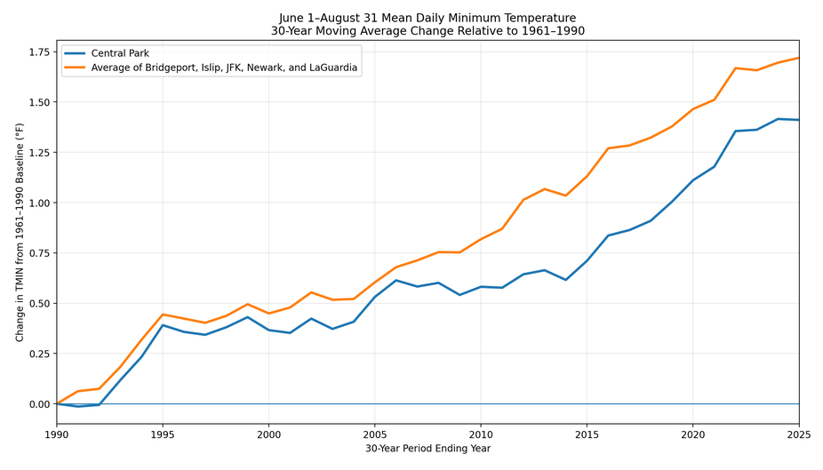
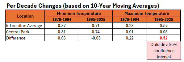
As summer concludes, additional charts illustrating the impact of Central Park's trees on its summer maximum temperature trend vs. select regional sites. Maximum temperatures are most impacted (consistent with the impact trees have on limiting the daily maximum temperature). Moreover, the difference between regional trends and Central Park is outside a 95% confidence interval for daily maximum temperatures during the 1995-2025 period. Maximum Temperatures: Minimum Temperatures:
-

2026-2027 Record-breaking El Nino
michsnowfreak replied to Stormchaserchuck1's topic in Weather Forecasting and Discussion
Makes sense. After almost any winter rainstorm there's a lake snow response. - Today
-
CSU MLP has a decent area of 5+% TOR for Sunday.
-
2026-2027 Record-breaking El Nino
bluewave replied to Stormchaserchuck1's topic in Weather Forecasting and Discussion
I don’t take any of this personally. It’s more comical than anything else. The squabbles in these threads are more like Napoleon Vs Uncle Rico than anything really serious. -
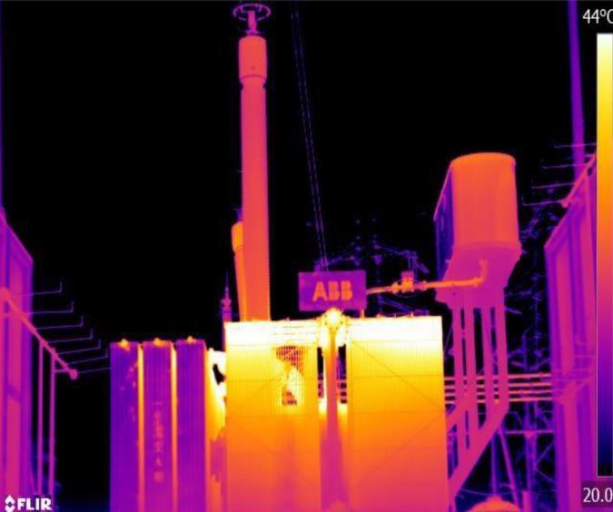
 As an example of why breakpoint detection is absolutely essential, and where there are no alternatives besides something like a pictorial history of the station, Coatesville is a winner. From 1946 on to 1982, Coatesville station was at the Newlinville electric substation. The electric substation is constructed about 1927 to supply the steel works in town, and takes high voltage transmission line power and steps it down. BIG transformers are involved. The Newlinville electrical substation was frequently redesigned to meet the needs of the steel works. Transformer technology improves over time, with less waste heat. A cooling pool is installed at one point to take transformer heat during high loads, and is removed after 2005. So, we have a station with massive heat sources, that are moving as the station expands, and we need to detect changes in the station environment. This obviates all the musings about what caused a precise shift at time X and magnitude Y--this microsite is literally a thermal zoo. Automated breakpoint detection is the only way to salvage this data. Attached is a figure showing estimated power increases over time, developed from historical uses. These increases would have forced numerous changes over time at the substation. And consider, if a new transformer/switchgear is being installed, it would occur at a new pad on the site, while the old transformer/switchgear remains in operation. On change over, the newer transformer/heat source has moved abruptly, and the old transformer idled and eventually removed. Breakpoint. And the new heat source is very likely southwest from the earlier heat source, and very likely further away from the weather station. Attached also is a random thermal image of a substation.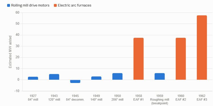
-
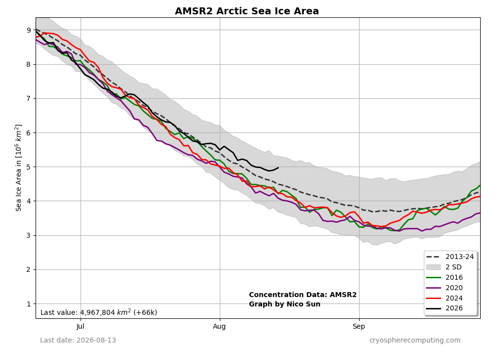
The relatively good news continues as regards the Arctic sea ice area:
-
Cracy considering we were 72 for a low last night here at KDTW.
-
https://mapletrustrx.com/# Maple Trust Rx