All Activity
- Past hour
-
December Natural Gas contract is almost right at $5... I usually say below $5 favors +NAO, and above $5 favors -NAO.. below $3 stronger +NAO, and above $8 stronger -NAO.. So right now neutral on NAO prediction there.
-
QBO should be negative.. March to April went from +11 to +6. When it changes phases it usually lasts at least 10 months. -QBO with El Nino favors Stratosphere warmings, but ENSO looks to be more Neutral this Winter. -QBO's with neg-Neutral ENSO have been known for cold December's then switching to warmer Jan-Feb (89-90, 05-06), but there's not enough data to say that for sure. My N. Atlantic SST method predicted +0.52 NAO last Winter (DJFM), and it ended up being +0.65. That makes it 14-5 on getting the right sign in real time since I came up with it in 2005. Also 10-9 within the estimated standard deviation of +0.54. The index runs May-Sept, so it's too early to say where it's going right now.
-
CPC's DJF 2025-26 Winter outlook
-

E PA/NJ/DE Spring 2025 Obs/Discussion
Albedoman replied to PhiEaglesfan712's topic in Philadelphia Region
- Today
-
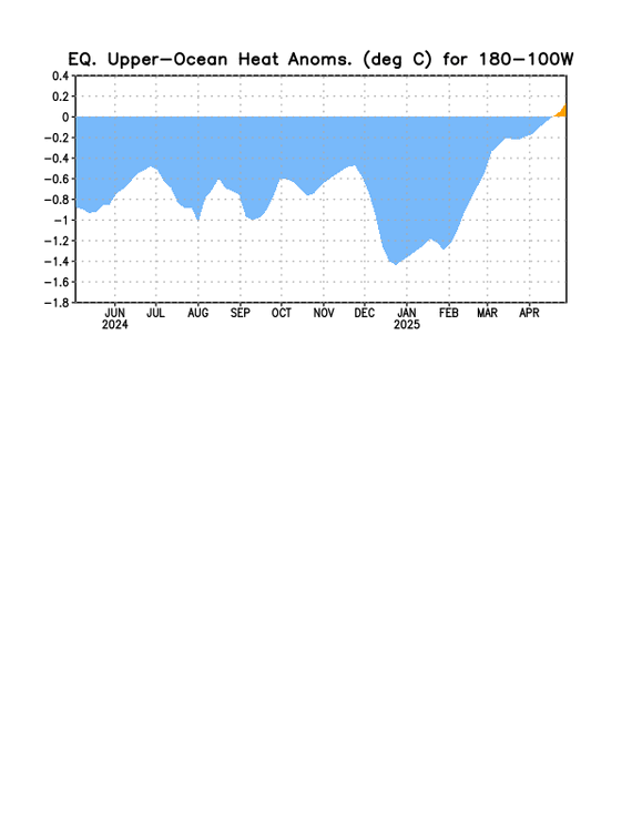
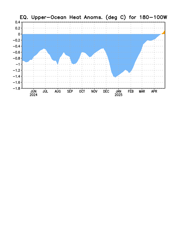
We now have a +OHC!
-
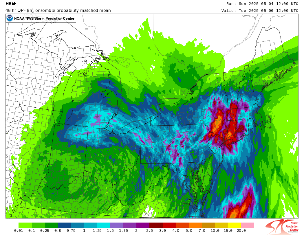
You can read about meteorological features, but it’s fascinating to see it all play out in realtime. Do you think some of those high end QPF depictions the next few days have a chance of verifying? I lean toward the Euro being more right than not, though I think it’s running a little hot. It’s not alone though.
-
I have been home from Florida for 65 days and I think we've had maybe 20 decent days. I'd be okay if we deleted march and April from the calendar.
-
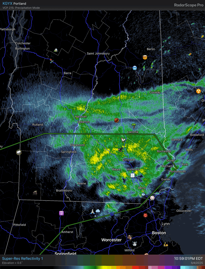
And here’s how that looks like on radar.

-
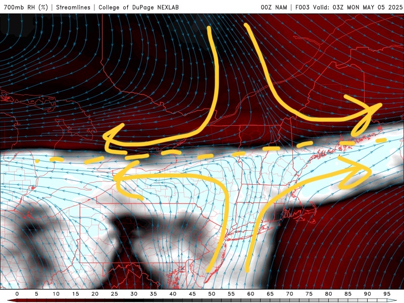
It’s been a steady moderate to heavy rain all night. There’s a squeeze play with the high in QB trying to sink southward and the southerly flow cranking up…so some decent fronto. Pretty much perfect deformation over us with the col right over my head.
-

2025 Lawns & Gardens Thread. Making Lawns Great Again
DavisStraight replied to Damage In Tolland's topic in New England
I think they have starter fertilizer with weed prevention, not sure how well it works since it's not the same as regular fertilizer. Depending on the size of the area the sod idea wasn't a bad idea. -
1.5” May total, so far, in my area of Greenfield.
-
Somebody down here might get smoked. I’m at .98” since Friday.
-
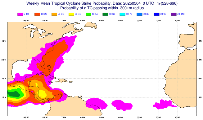
Elevated TC threat SE US May 26th-June 1st per Euto Weeklies fwiw: signal has persisted for a few days for then and it looks like a W Caribbean/gyre origin:
-
Sorry bud
-
Meanwhile I wore a sweater and the heat ran all day. Lol spring in the midwest
-
Noone remembers summers.
-
I have this theory, post 2016 every third winter has been a snowless torch fest. 16-17, 19-20, 22-23 The latter two had totals less than an inch for the 95 corridor. This upcoming winter will test the theory to see if it holds.
-
About .35” in SW Nassua. Finally got through the trees when we had decent rates. I hope this isn’t another warm season tracking rain like snow accumulations.
-
There seems to be some moisture coming. Should be beneficial rains at a time when the region can benefit from it, soak it up… during green up. The vegetation is thirsty when it becomes active again.

-
That's the setup for an EPIC FEBRUARY PATTERN
-
My car is buried under maple keys. It's ridiculous.
-
Although varying intensities, it has been raining nonstop here since 4 PM.
-
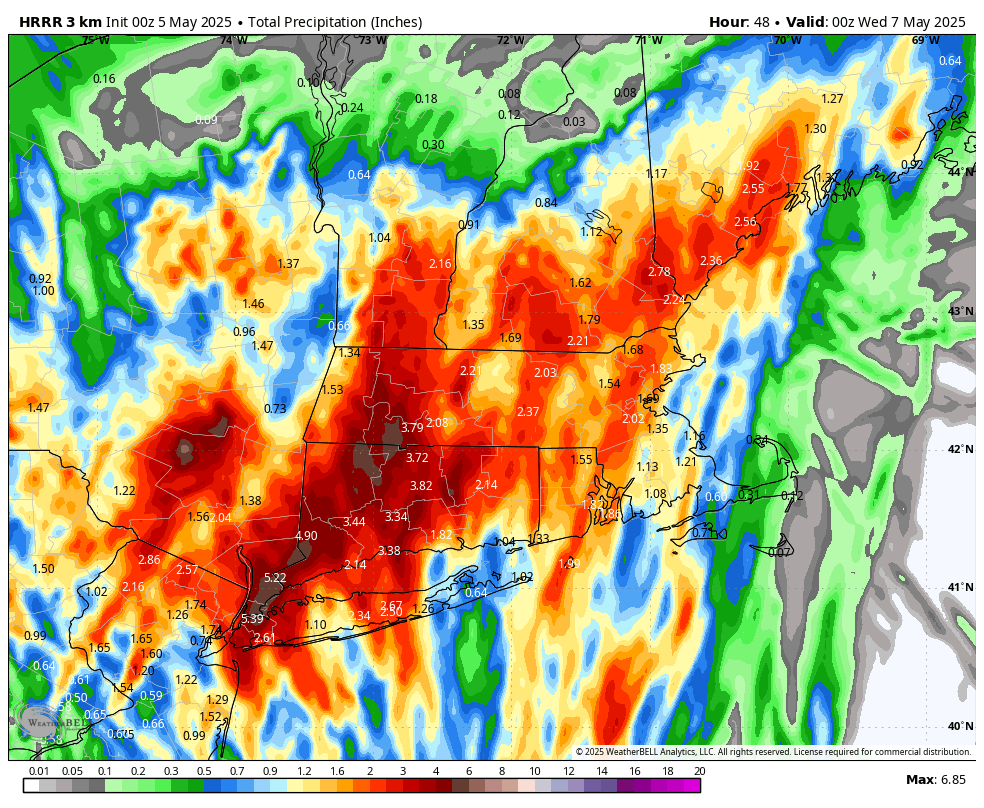
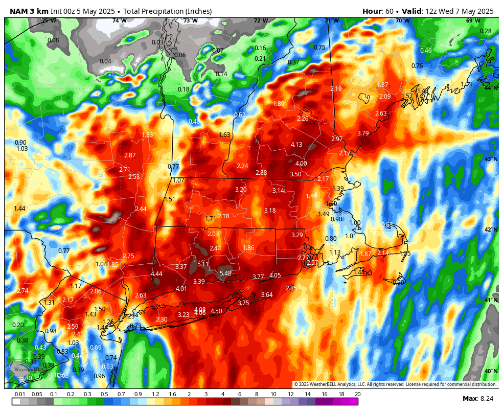
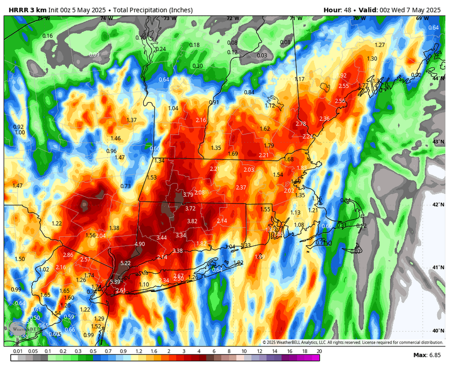
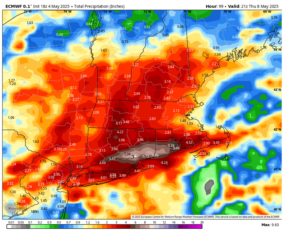
HREF looks wet for central and western new england through Tuesday (12z means some of this has fallen already).

-
The infamous zone of suck rears its ugly head once again. Folks in the interior think I’m full of it but if you walk outside it’s like standing on the side of a fishing boat with a bunch of salty, pudgy men wondering where it all went wrong.
-
I was in Nassau today. More rain than here at home


.thumb.png.4150b06c63a21f61052e47a612bf1818.png)