All Activity
- Past hour
-
Gusty winds and flurries here this morning. Peak gust was 41. Saw that Camp David gusted to 53 overnight. 32°
-
I grew up in Long Beach on the South Shore and we only needed the AC a handful of times back in the 1970s. First for the August 1973 heatwave and then the July 1977 heatwave. We gradually increased the AC usage during the 1980s and especially the early 1990s. By the time we reached 2010, we had three ACs running much of the time compared to only one in the 1970s. Plus there was a rapid expansion of central AC even in Long Beach when it was a rarity near the shore in the 1970s. This is one of the reasons that HVAC is such a good career opportunity for people due to the increased demand in a warming world. As for the UHI issue, there was a 10°+ difference between NYC during 1896 heatwave and the surrounding countryside. This mostly occurs with summer heatwaves where the city absorbs more heat during the day. It also occurs during calm and clear nights with radiational cooling. The growth of skyscrapers in Western Brooklyn and Queens certainly changes the character of the neighborhood and of course you can see the change in the skyline since around 2004. But prior to that that area had densely packed lower rise buildings built of bricks. These new high rises are mainly glass and steel which absorb significantly less solar energy than bricks do. Plus a cluster of tall buildings will create a big area of shade which prevents the streets and sidewalks from absorbing as much heat as they did with smaller buildings with less shadows. The warmest parts of NYC are in Queens near spots like Corona were small to medium size brick structures dominate. So changing from lower rise brick and concrete structures to skyscrapers may not change the UHI much in Western Brooklyn and Queens to really be noticeable to residents there. That’s why I said a drop in the bucket to what was already one of the largest UHI zones in North America.
-
Looks good now for a 2-3 inches of snow from DC to Philly up I-95. Just seems like the potential rug pull is high with this one.
-

December 2025 regional war/obs/disco thread
Kitz Craver replied to Torch Tiger's topic in New England
That 0z Euro was a parade of snow storms for NNE. -

December 2025 regional war/obs/disco thread
powderfreak replied to Torch Tiger's topic in New England
Another 3” overnight on the car, around 6” for the event. -

December 2025 regional war/obs/disco thread
Damage In Tolland replied to Torch Tiger's topic in New England
Whatever we do get Saturday night is wiped out mid week next week unfortunately -
currently 36/28, partly cloudy, occasional north breeze
-

Winter 2025-26 Medium/Long Range Discussion
Chambana replied to michsnowfreak's topic in Lakes/Ohio Valley
So this is NOT our moment -
December 2025 regional war/obs/disco thread
Damage In Tolland replied to Torch Tiger's topic in New England
All overnight ensembles still have it so we are good for now -

Minor snow possible sunday 12/14/25
MJO812 replied to WeatherGeek2025's topic in New York City Metro
Gfs is still a miss but the icon, nam and rgem shifted more to the northwest. Euro up next. Plenty of time for shifts -
Always... well usually.
- Today
-

December 2025 regional war/obs/disco thread
TauntonBlizzard2013 replied to Torch Tiger's topic in New England
Bleh, this sucks. Get ready for the cutters -
35F currently in E CT, and very slippery outside. We got about .17” of rain
-

Central PA Winter 25/26 Discussion and Obs
Ruin replied to MAG5035's topic in Upstate New York/Pennsylvania
So now Saturday night into Sunday. Little to no snow. We've all been part of this song-and-dance before we have all this damn cold weather. And nothing to show for it, except little dusting here and there people will say it's too early. It's still early in the year. It's too early in the winter. And then what happens? We get a warm up and nothing happens after that. And now there's signals for a wawarml -

Winter 2025-26 Medium/Long Range Discussion
A-L-E-K replied to michsnowfreak's topic in Lakes/Ohio Valley
Couple days of cad and then we go Oregon mode until at least January Hot start will be a distant memory -

December 2025 Short/Medium Range Forecast Thread
John1122 replied to John1122's topic in Tennessee Valley
Got a dusting of snow, had a couple of decent showers. 31 degrees. -

December 2025 regional war/obs/disco thread
SouthCoastMA replied to Torch Tiger's topic in New England
6z GFS is a clean whiff. On to 12/21? -
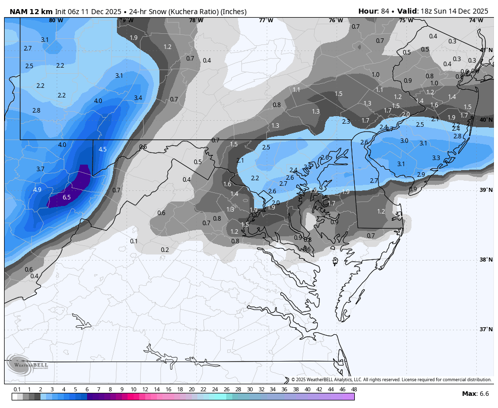
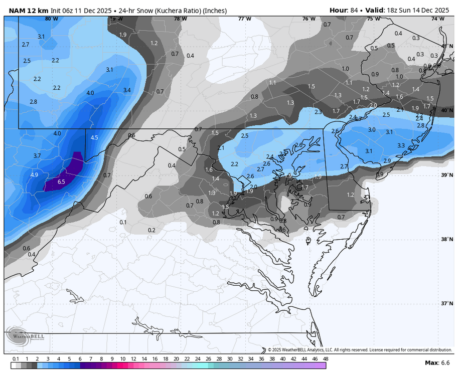
6 NAM is meh for all
-
WB 6Z 12K NAM for Sunday.

-

12/12: The little Friday clipper that could? Or won't.
WesternFringe replied to dailylurker's topic in Mid Atlantic
I will take the Euro/NAM combo for an inch of snow on top of our snowpack. I will take pictures for you! -
New York City finished December 1-10 with a mean temperature of 34.1F (1.2C). That was the coldest first 10 days of December since 2007 and sixth coldest since 2000. A quick look at the guidance shows that a light snow event (probably 1"-3") across the New York City area is likely on Sunday. Given how snow events have been challenging to come by in recent years, to some it might seem like a big event. Even the previously bone-dry NBM shows 0.12" QPF.
-

December 2025 Short/Medium Range Forecast Thread
louise.caison233 replied to John1122's topic in Tennessee Valley
The pattern looks messy, but there’s still time for shifts. One good storm can flip the mood fast, so I’m not giving up hope yet. -
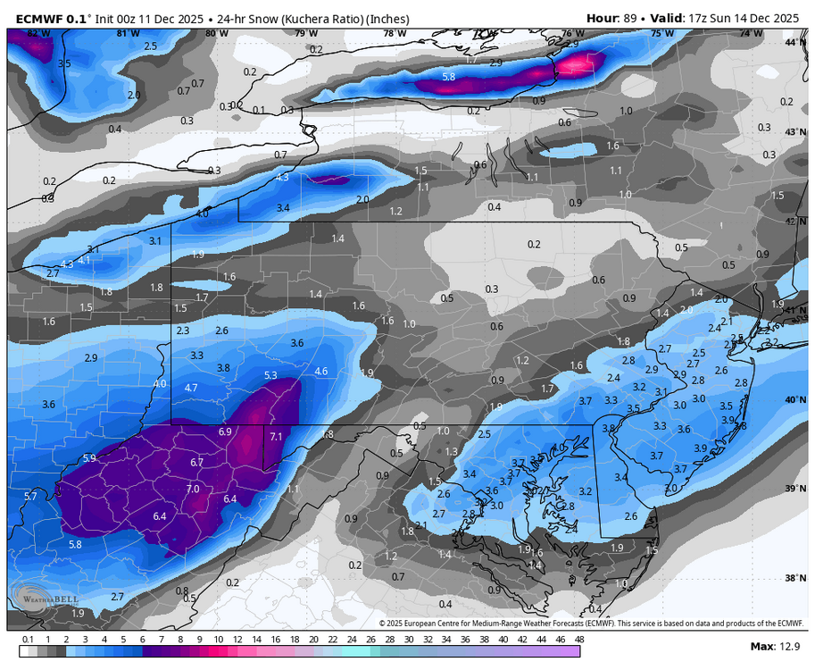
Doesn’t get much better than the 0z euro / cmc combo for the I-95 metro corridor
-

E PA/NJ/DE Winter 2025-26 Obs/Discussion
RedSky replied to LVblizzard's topic in Philadelphia Region
Euro 1-3" north to south All guidance shifting south -

Central PA Winter 25/26 Discussion and Obs
MAG5035 replied to MAG5035's topic in Upstate New York/Pennsylvania
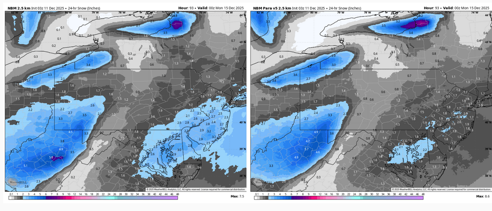
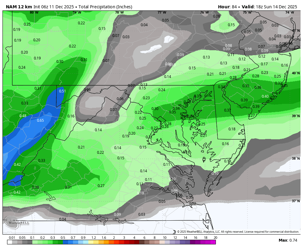
It’s even more pronounced on the other globals. Especially on the GFS, which doesn’t have a snowflake make it east of I-99. GFS is probably on the far end of that side of the spectrum (and a bit further south with the wave as well), but that shadow off the Alleghenies is probably going to be a thing with this setup. The wave isn’t all that strong and doesn’t have much moisture to work with. Most modeling doesn’t have a closed surface low until this hits the coast, which is why the second snow swath shows up in SE PA and the DC to NYC 95 corridor. Otherwise the wave is running on a westerly flow, which downslopes off the east side of the Alleghenies. The 0z NAM had a more pronounced shortwave as it passes under PA, which made that about the only model to not have the shadow. Other modelling tonight 3z NBM (National Blend of Models) vs NBM v5. The v5 is an updated version of the NBM being tested ahead of being deployed April 2026. 0z Euro