All Activity
- Past hour
-
Not sure why, but this sure hasn't felt like a historically warm month here in Ohio. It seems like the cooler than normal days have stood out more than the warmer than normal days. Maybe it's just my old a** getting less and less cold tolerant
-
There's an interesting techy aspect that Brian and I have monitored over the years having to do with machine/MOS numbers never seemingly able to catch up to the seasonal movement toward heat in springs. This effect doesn't appear to be as such in autumn when going colder. It has to do with MOS numbers being too low on days when the sun is very strong. MOS has a 'memory' so to speak. That memory is Climatology. It's complex though... MEX, for example, has small climate enhancing of the immediate day's values... which growns in weighting out in time. Such that D5 of that string has a ton. That is why when we look at D5 and it may say 80 for high temperature, when the climate on that day is say 60 ... that means you have a signal that must be extreme coming from the contributing model input. Because it is not only 20 points over the climate, the climate is supposed to be weighting the values from the metrically deduced numbers. That is why once in coon's age you get that 96 in April ... the MEX number on that day 5 might have been 20 points over. So MET and MAV being short term, in theory the climate weight is lower ...but it is not zero, either. It's hard to guess how much the MOS for D1 and D2 are being effected by climate weighting, but it could be the reason why these days will tend to be a degree or two colder than what actually takes place. It suspiciously seems like Climate Change might be part of the culprit. The other complication is how much so... I believe the climate in those MOS products are based on 30 year means. But those are not "running averages" ... so if the climate is improving steeply in 30 years and it is not running... and suppose the MOS day's climate weight is based up 27 year old means, then the weighting could be introducing larger error. As such ...I "think" the recent 30 year adjustment went in over the last 5 years...so we're at the earlier end, and we are definitely in a steep CC predicament. That said, the D1 and D2 are at the lower weighted end so makes the crushingly nerdy fetish of Asperger temperature watching like those idiots out there along the train track. It's a 4 line that runs 100 feet from my front door. They set up tripods and film freight trains going by. What the f is up with that! I think it's called 'train spotting' or ... ? who cares I don't care to look it up. I hate the f'n train. It's loud and disruptive. It vibrates the house on minutes after minutes worth of sometimes several times per day. They couple up and decouple half mile long screaching screaming steel on steel ending in lightning bolt 100 feet away bangs. 1.5 million metric tons of 'em, between 1 and 4 am. They've taken to parking long lines of shipping containers double stacked, that are holding garbage - literally garbage that after have sat parked under summer sun in 97 F heat ... stink of rotting vomit so vile as to challenge the very endurance of man ... They're ruining life for myself, my neighbors.. the neighborhood. It's gotta be lowering property values... I mean Jesus H Christ - or lack thereof.. We've complained to the town, who's clearly getting a kick back form CGI ... otherwise we might apply for a Federal injunction of some kind. To me, it doesn't matter if the latter owns the rail. It's should be no different than house that puts on loud music on and disturbs the surrounding peace. That's not allowed!? why should corporate kuntitude be able to dump society's anal content 100 feet from our f'n front doors and walk away. So, along comes these train dweebles to appreciate fuckin' trains? Okay.
-
lush and green
-
Well we can't complain about the drought then complain about the rain, lol
-

Occasional Thoughts on Climate Change
TheClimateChanger replied to donsutherland1's topic in Climate Change
I don't know. Recent heating seems to be overpowering any natural variability/oscillations. Obviously, not every year is warmer than the previous, but the change seems to be more pronounced over the past several years - and I would expect that trend to continue at least through next year with the likely strong El Nino. -
April 27 2002: Heavy snow falls over the Twin Cities and central Minnesota. Chanhassen receives 6 inches, and vivid lightning is seen with the snow during the evening. 1996: Embarrass records a low of 9 degrees. Some central, and most northern, Minnesota lakes are still ice-covered. 1921: A late season blizzard hits Hibbing. The temperature was 75 degrees three days earlier. For Monday, April 27, 2026 1899 - A tornado struck Kirksville, MO, killing 34 persons and destroying 300 buildings. (David Ludlum) 1931 - The temperature at Pahala, located on the main island of Hawaii, soared to 100 degrees to establish a state record. (The Weather Channel) 1942 - A destructive tornado swept across Rogers County and Mayes County in Oklahoma. The tornado struck the town of Pryor killing 52 persons and causing two million dollars damage. (David Ludlum) 1987 - Forty-two cities in the western and south central U.S. reported record high temperatures for the date. The afternoon high of 87 degrees at Olympia WA was an April record, and highs of 92 degrees at Boise ID, 95 degrees at Monroe LA, and 96 degrees at Sacramento CA tied April records. (The National Weather Summary) More than 300 daily temperature records fell by the wayside during a two week long heat wave across thirty-four states in the southern and western U.S. Thirteen cities established records for the month of April. (Sandra and TI Richard Sanders - 1987) 1988 - Mount Washington NH reported seven feet of snow in ten days, pushing their snowfall total for the month past the previous record of 89.3 inches set in 1975. (The National Weather Summary) 1989 - Thunderstorms produced severe weather from the Lower and Middle Mississippi Valley to Virginia and the Carolinas. Hail up to four and a half inches in diameter caused five million dollars damage around Omaha NE. Thunderstorms spawned eleven tornadoes, and there were 160 other reports of large hail and damaging winds. (The National Weather Summary) (Storm Data) 1990 - Thunderstorms produced severe weather in eastern Texas and the Lower Mississippi Valley. Severe thunderstorms spawned thirteen tornadoes in Texas and twelve in Louisiana. A tornado southwest of Coolidge TX injured eight persons and caused more than five million dollars damage. There were also eighty-five reports of large hail and damaging winds, with baseball size hail reported at Mexia TX and Shreveport LA. (The National Weather Summary) (Storm Data) Forty-three cities in the eastern U.S. reported record high temperatures for the date. Records highs included 94 degrees at Charleston WV, 95 degrees at Baltimore MD and96 degrees at Richmond VA. (The National Weather Summary) 2011 - An estimated 305 tornados between the 27th and 28th sets a record for the largest outbreak ever recorded, including two EF-5s, four EF-4s and 21 EF-3s. Arkansas through Mississippi, Alabama, Georgia, southern Tennessee, Virginia to Pennsylvania and New York were all affected. An estimated 300 died including 210 in Alabama alone. This brought the April total past 600, the most in any month in recorded US weather history.
-
Slight risk today has been stretched SW into NE Texas. Last few runs of the HRRR is showing some storms late this afternoon/evening forming near Dallas and points east. There's also potential for isolated storms south/west. Hail/wind is probably the biggest threat, with isolated tornadoes still a possibility. Tomorrow will have another threat for severe weather with storms potentially initiating near Sherman and headed south/east from there.
-
Well, since the 90 degree day a week and a half ago.
-
Rainy, chilly morning with temps in the upper 30's. Flood watch out for NE MN.
-
My ornamental grasses starting growing in the heat of two weeks ago only to be shocked by the hard freeze last week. As a result it all looks like shit currently. The lawn is coming along decently though.
-

Potential Sever Weather Outbreak 4/27/2026
sbnwx85 replied to pen_artist's topic in Lakes/Ohio Valley
The most exciting part of this event up here might be the wake low behind the rain this afternoon.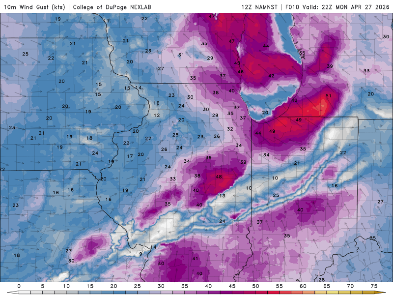
-
Nice to see the ground not completely dried out for once. Been awhile. Now if we can string together a few 70 and sunny days maybe itll feel like a real spring lol
-
Are you all leaf out all trees?
- Today
-

2026-2027 El Nino
PhiEaglesfan712 replied to Stormchaserchuck1's topic in Weather Forecasting and Discussion
OHC peaks - strong/super el ninos 1982-83: 2.07 (October) 1986-88: 1.22 (January 1987) 1991-92: 1.98 (February) 1997-98: 2.56 (October) 2009-10: 1.75 (November) 2015-16: 1.97 (August) 2023-24: 1.45 (November) -

Potential Sever Weather Outbreak 4/27/2026
A-L-E-K replied to pen_artist's topic in Lakes/Ohio Valley
shame about missing the bangers, glad for more consolation prize rain -
If there's more sun than cloud in late April, the max will probably be AN at least 90% of the time. Last 2 days' max here averaged 61, which is 4° AN. The minima averaged 26, or 6° BN. The sun is mid-August strong.
-
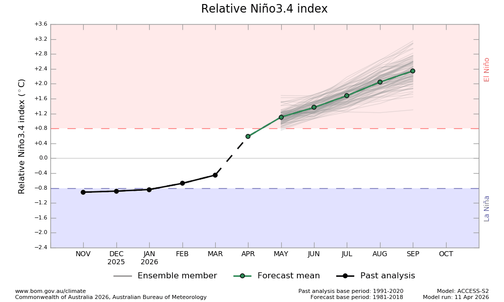
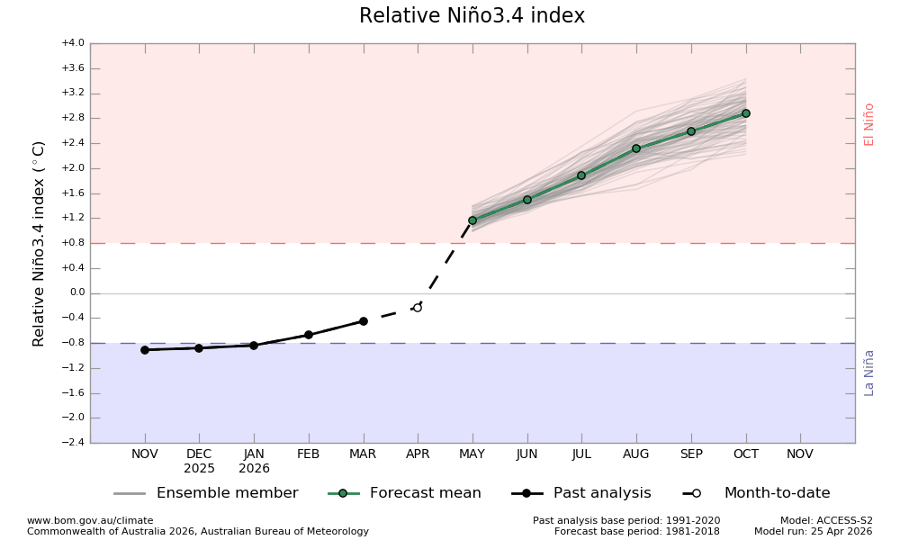
The latest BoA relative was just released. As expected, it cooled way down from the April Nino 3.4 prog of +0.6 as it is now a much more realistic -0.2 (that actually will likely end up slightly too cool as I expect it verify -0.1 to 0.0). However, despite that marked cooling of April, it warmed for its Sept prog from ~+2.35 to +2.6. Also, this is the first run with Oct, which it has at ~+2.85. On the one hand, one should keep in mind how much it overdid ONI in 2023. OTOH, this latest has RONI near the level it had ONI in 2023. So, although we should be aware of a quite possible warm bias at play here thus causing the RONI prog to be overstated, we should also be aware that it is currently implicitly progging ~0.5C warmer RONI vs 2023. Keep in mind that RONI peaked at only ~+1.5 in 2023-4. We’re very likely headed to a significantly warmer RONI peak in 2026-7: BoA RONI prog from 2 weeks ago: a ridiculous +0.6 April and a +2.35 Sept: Today’s BoA RONI prog: much more realistic cooler -0.2 April but Sept a warmer +2.6; first run with Oct (+2.85):
-
Got 0.12" in ATL metro Saturday. FFC mentions multiple rounds of rain coming this week but also said models may be underrepresenting dry conditions and most won't see much more than an inch.
-

Occasional Thoughts on Climate Change
WolfStock1 replied to donsutherland1's topic in Climate Change
Hmm - this implies annual oscillation of the Earth's temperature, does it not? I didn't think that was a thing. I know there are oscillations, but they tend to be correlated with ENSO cycles and such, do they not? IOW - seems to me this is just a subset of global mean temperature - e.g. the northern hemisphere only, is it not? -

Potential Sever Weather Outbreak 4/27/2026
Jackstraw replied to pen_artist's topic in Lakes/Ohio Valley
Nah. Old chasing friend of mine was trying to talk me into going with him last night. We've been talking about this setup, the potential mess it could be most of the weekend. That's the area, IMO, I'd be IF I were chasing. I decided not to go. He left last night is in a hotel just S of Springfield. I'll be playing base camp for him lol. Do believe for any lone sups its gonna be highest chance in that area. Could be a lot of embedded sups and MCV spin ups but chasing those just sux. Think kind of like the last system, Tail End Charlies will be best isolated sup options when you get bows and shrimps like this setup could be full of. Like you said that area just got elevated to MOD so yeah, thats a good call IMO if your going. Anything isolated East into IL/IN is probably going to be close to or after dark. Another reason I'm not going. Good chance for a late night MCS/MCV rolling through here. I've got a donkey, 2 goats and 2 dogs. They get quite upset when there's big thunder dragons outside lol. Good luck to anyone who dares and be safe. Idiots IPhones and storms don't mix lol. -
Mother's day was always the hope. Looks like some are still trying to put lipstick on the pig, even though the models have been consistent about this for about 2 weeks now.
-
You need to suffer another 15 years of it and then you'll be as iron-hulled to it as the ships Labrador never claimed. You'll limp into port every spring surviving by the notion that 70 in May is actually a motherfucking bargain and you'll be happy. ha! If it is 70 and with more sun than cloud days ...? Shiiiii I'm calling that a relative win and a day. But yeah.. looks like in 2 weeks when the April/NASA numbers are out, the graph will again register that whether we are above normal for April or not, we will in comparison to everywhere else, be below ... every where else. Since October, 2025 we've be winning that distinction, save for one or two weak argument months. Altho... heh at any time NASA may cease to exist because of the creepy "operation silence the consilience" going on.
-
Today is a stunner though. Went into work late so I could sit in the sun with my coffee and listen to the birds.
-
61 / 48 off a low of 35. Nicest day of the week coming up. Not bad Tuesday but clouds build in ahead of the next batch of rain on Wed/Thu. Continued cool and possibly wet one or the whole weekend. Moderation betwen May 5 - 9th and next shot at 70s or warmer then but it may take till mid month to push heights / riding east for any persistent tineframe.
-
Losing May is like losing December in the winter.


