All Activity
- Past hour
-

2025-2026 ENSO
donsutherland1 replied to 40/70 Benchmark's topic in Weather Forecasting and Discussion
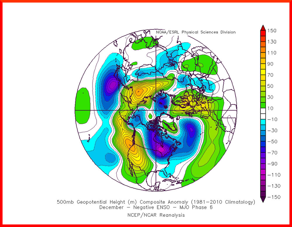
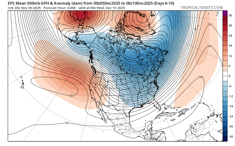
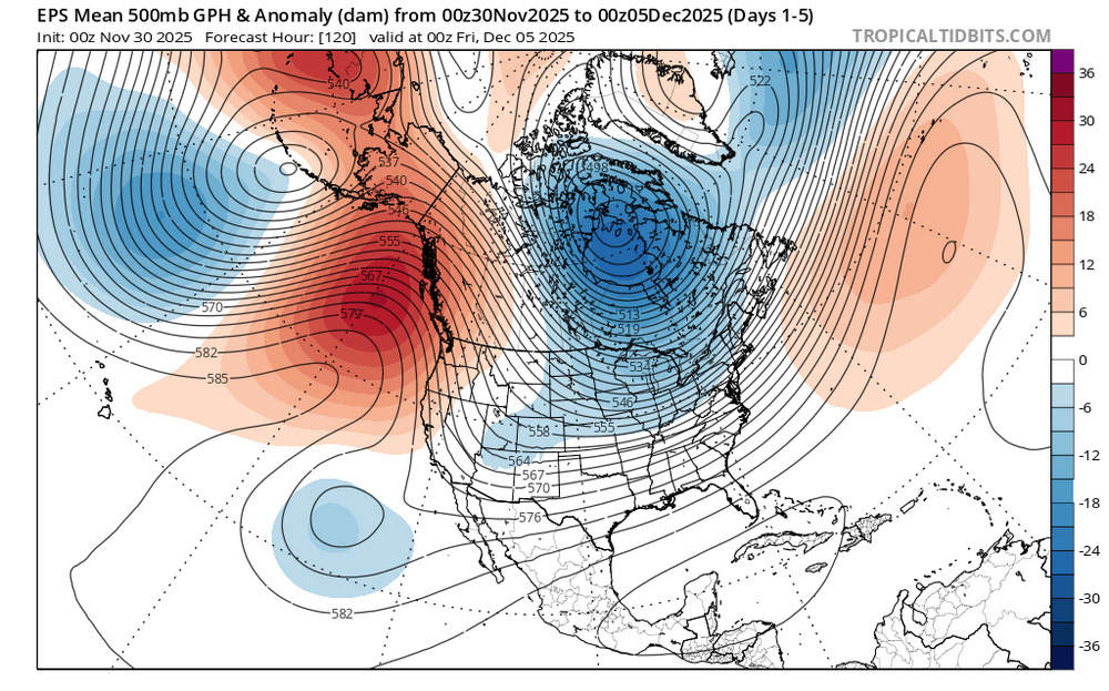
The 11/30 0z and 6z GEFS has returned to a warmer outlook for much of North America after December 10th. It offers a credible alternative scenario. I'm still going with the EPS/ECMWF weeklies, as the GEFS has shown inconsistency. Moreover, the size of the rebound in temperatures (December 11-20 vs. December 1-10) would be both extreme and rare. Nevertheless, a look at the alternative scenario is still in order as a muted variation is plausible. The GEFS's development of a fairly strong PNA- is the key variable differentiating it from the colder baseline idea shown on the EPS. The latest two cycles of the GEFS show the development of a WPO-/EPO+/AO-/PNA- pattern. The GEFS maps are consistent with the largest cluster for the December 5-15 period (39%) of cases. WPO-/EPO+/AO-/PNA- Maps (Largest December 5-15 cluster): 500 mb Height Anomalies: Temperature Anomalies: GEFS (11/30 6z cycle): Days 11-15: 500 mb Height Anomalies (5-day average): Temperature anomalies (5-day average): -
Hard to believe it’s not even december yet. Feels good to have frozen and be tracking multiple threats. Sleet continues, 33.8
-
Pittsburgh PA Fall 2025 Thread
Rd9108 replied to TheClimateChanger's topic in Upstate New York/Pennsylvania
Idk about 3-5. I think 2-4 is a safe bet with 4 at the high end. Also Ritual sorry about your dog. Its tough losing a dog. Especially since they become part of the family. -

Central PA Fall Discussions and Obs
Blizzard92 replied to ChescoWx's topic in Upstate New York/Pennsylvania
We ended up with our first 0.1" closer to Linglestown! -
36 / 28 clouds and some light rain showers to the west. Nov will end on a cold note and push much of the location below normal with some near or slightly above. Overall colder period the next 10 days with the first storm threat looking to target areas N+W with mix/snow and mix to rain here. Next weekend Dec 5-6 should see the next threat as trough deepens. Very cold air to our north and west comes in waves of very - much below normal day or two. Brunt of the cold stays into the GL/NE.
-

Nov 28-30th Post Turkey Day Winter Storm
OrdIowPitMsp replied to Chicago Storm's topic in Lakes/Ohio Valley
3.9” at MSP 6.5” WFO Chanhassen. Measuring approximately 4.5” imby. Great spread the wealth event for our subforum. -
E PA/NJ/DE Autumn 2025 Obs/Discussion
JTA66 replied to PhiEaglesfan712's topic in Philadelphia Region
WORST…WINTER…EVER!!! I’d rather have an all out torch than get d*** teased like that. -
Okay it’s sticking. So exciting!
-
First Measurable snow of the season NW of Winchester. Beautiful morning.
-
Awww sleet sleet sleet.
-
PL imby. Nice to get the first winter precip out of the way before December.
-

First Winter Storm to kickoff 2025-26 Winter season
Modfan2 replied to Baroclinic Zone's topic in New England
So, how much rain are we getting Tuesday? -
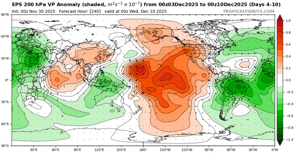
A new tropical oscillation called the TWISO has been recently discovered. So maybe the reason we are getting a strong MJO 6 gradient pattern in early December is somehow related to it being out of phase with the MJO. Plus the split forcing between the Maritime Continent and the Western Hemisphere could also be creating an interference pattern. Models showing a MJO 6 interference gradient pattern in early December https://www.pnas.org/doi/10.1073/pnas.2511549122 The tropical climate variability is characterized by various oscillations across a range of timescales. Oscillations that imprint the tropical mean state are generally attributed to slow processes, such as the seasonal cycle or interannual variability. Here, we identify a pronounced tropics-wide intraseasonal oscillation (TWISO) in satellite observations and reanalyses. This oscillation, with a period of 30 to 60 d, is evident across multiple variables and involves interactions between convection, radiation, surface fluxes, and large-scale circulation. It is primarily manifested as convective perturbations in the tropical Indo-Pacific warm pool accompanied by oscillations in the large-scale tropical overturning circulation. Here, we examine the relationship between TWISO, the Madden–Julian Oscillation (MJO), and the instability of radiative-convective equilibrium. Certain phases of TWISO coincide with specific phases of the MJO, suggesting a potential connection between the two. However, although the MJO can amplify the oscillation amplitude of TWISO, it is not essential for TWISO to occur. Finally, due to its broad manifestation across the tropics, TWISO potentially exerts widespread influence on tropical weather and climate at regional scales.
-
E PA/NJ/DE Autumn 2025 Obs/Discussion
PhiEaglesfan712 replied to PhiEaglesfan712's topic in Philadelphia Region
The best example is 89-90. We had the coldest December on record, then the weather turned springlike when the calender flipped to January. -
Moderate snow and a nice dusting.
-

Central PA Fall Discussions and Obs
mahantango#1 replied to ChescoWx's topic in Upstate New York/Pennsylvania
Any reports from the "heat island"? -
What a lovely surprise. Temp 35 at my house so not sure how well it will stick. Big good size flakes
-

Winter 2025-26 Medium/Long Range Discussion
Baum replied to michsnowfreak's topic in Lakes/Ohio Valley
The snow rake maybe in action after a decade of dormancy -

E PA/NJ/DE Winter 2025-26 Obs/Discussion
penndotguy replied to LVblizzard's topic in Philadelphia Region
34f Snow falling here in Spring Twp Berks. -
Temp getting interesting. 33.6 and dropping, dewpoint 29. Might end as snow before precip moves out? (Ashburn VA)
-
First Winter Storm to kickoff 2025-26 Winter season
gonegalt replied to Baroclinic Zone's topic in New England
Ya, buzz kings never got dope sick. A relatively small and self-limiting community, druggies, used the dope term differently but population-wide dopers are buzzkings, potheads. -
Westminster mesonet site is going to wet bub to 32°. You might get a solid coating of snow.
-
A dusting in Finksburg, Carroll County at the farm!


