All Activity
- Past hour
-

November 2025 general discussions and probable topic derailings ...
vortex95 replied to Typhoon Tip's topic in New England
Model backed off.
-
Overnight Wednesday, November 5, 2025 Wind Event
vortex95 replied to weatherwiz's topic in New England
Models obviously backed off since 18z yesterday. Low once near EPM is "only" 987 mb, compared to 979 mb earlier. -
Looking at the Snow Maps. For whatever Reason the GFS or Euro apparently don't "see" High Knob in Wise County.
-
Glad this weather is in it's way out. Low of 36 and a high of 73.
-
She is talking about his sheer lunacy, nothing to do with his weather posts. He has completely lost it.
-

Overnight Wednesday, November 5, 2025 Wind Event
HoarfrostHubb replied to weatherwiz's topic in New England
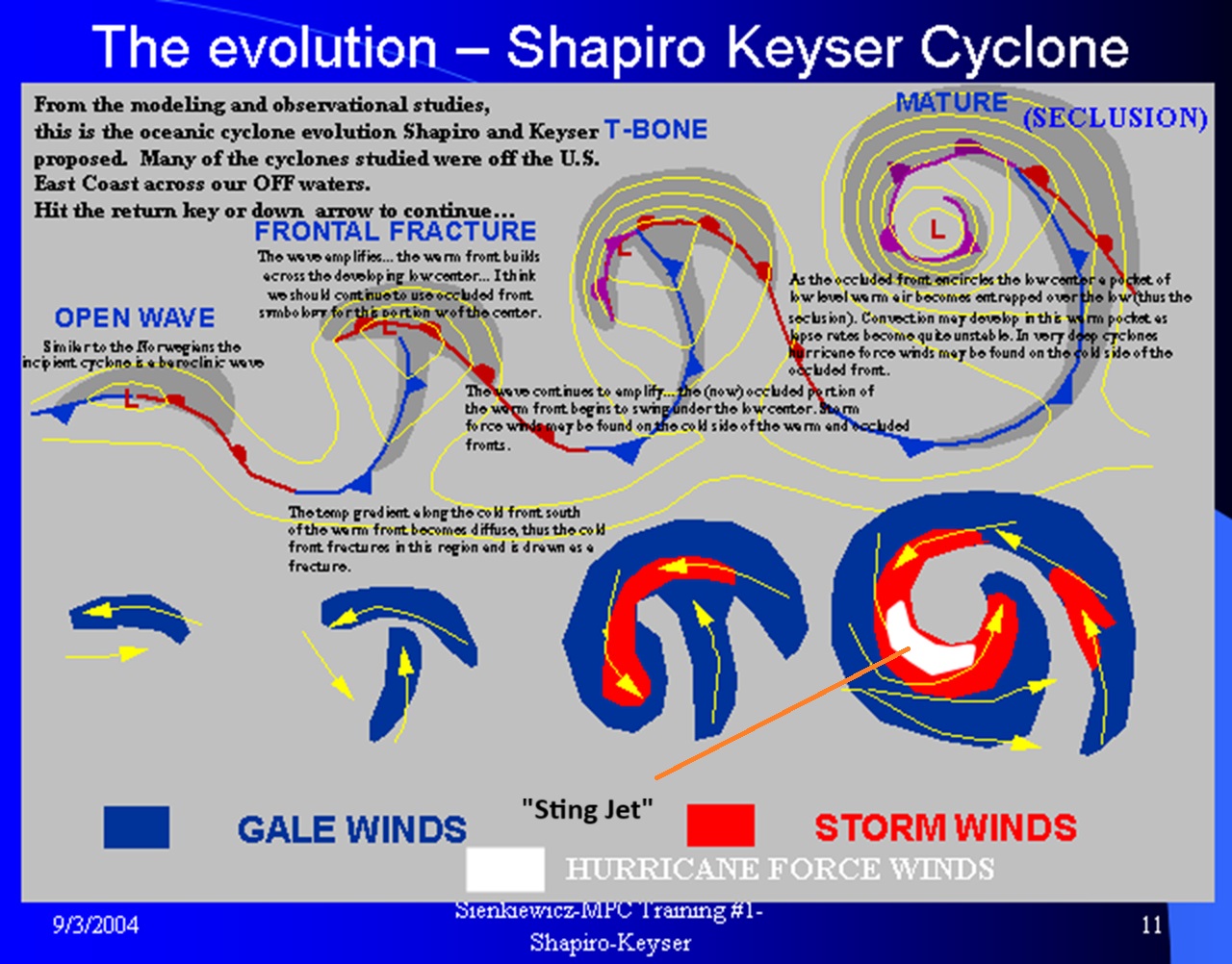
Any signs of a sting jet being modeled? -

Overnight Wednesday, November 5, 2025 Wind Event
WinterWolf replied to weatherwiz's topic in New England
That’s why it’s called historic lol…by the name and by the definition, it’s only supposed happen a handful of times..or else it wouldn’t be historic. And yes, I’d never trade our big bombs for a 3-6” Midwest blizzard no matter what…they can keep those. -
Anyways, atmosphere and weather test completed and I think it went pretty well!
-
Crazy to say this about one of our best posters in regards to their meteorological posts
-
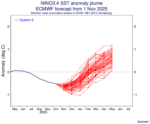
Eric Webb expects a rapid -IOD collapse starting soon, which models are showing the effects of as I showed on their Dec IO SST anomaly maps. He’s expecting El Niño to get started very early, which he said elsewhere could conceivably save Feb from being a mild month (we’ll see): A more rapid shift towards El Niño is probably the one wild card we could play that would have the potential to significantly alter the outcome of the latter part of this winter/February in our favor (though even then it wouldn't be a guarantee that things would shift favorably even in that scenario).
-
On a less pessimistic note than the past couple posts the GFS shows an amazing early season upslope/cold core lapse rate thingy happening on Monday! Gets parts of WV to one foot
-
Paul Roundy @PaulRoundy1 ECMWF clearly moving toward El Niño solutions this spring. Huge Maritime Continent westerly wind event developing, which will move warm water volume from the eastern Indian Ocean to the West Pacific. In the meantime, Pacific trade wind surge will maintain La Niña conditions for a couple more months. Paul Roundy @PaulRoundy1· 8h In the meantime, ECMWF is moving toward the OLR projections solution for December. Subseasonal signal suggests opportunity for eastern US cold/stormy conditions in early December.
-
This ( latest update ) is even more robust in terms of lessening winds, ie. stratospheric zonal winds.
-
Starting to get excited about the potential on this one.
-
Anything outside of HR 60 to 90 just treat with skepticism.
-
This winter shall be called: "the winter of the hybrid clippers" My favorite type of setup
-

November 2025 general discussions and probable topic derailings ...
powderfreak replied to Typhoon Tip's topic in New England
Yeah those 1500ft+ spots should clean up. Even 1,000ft out that way. - Today
-
-
-
a bit of a side note on weather. Louisville airport reported smoke after the plane crash
-

Central PA Fall Discussions and Obs
pawatch replied to ChescoWx's topic in Upstate New York/Pennsylvania
The wind is just a blowing and the leaves keep falling. Got a mow in today, mostly grass and a few leaves. probably next one I will be bagging. -

E PA/NJ/DE Autumn 2025 Obs/Discussion
Birds~69 replied to PhiEaglesfan712's topic in Philadelphia Region
YEEHAW! (61F/Expected low 41F)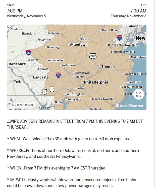
-
The November Euro seasonals are in. January looks decent. December could likely be colder than what it depicts, ESPECIALLY if the Euro weeklies from today are correct. Those weeklies look frigid through mid month. Warm Feb-April. But if we get Dec-Jan, we take it an run.
-

November 2025 general discussions and probable topic derailings ...
dendrite replied to Typhoon Tip's topic in New England
Yeah looks like there could be some decent accums in the slightly higher terrain in Coos and adjacent ME tonight. -
As of 4 pm, the high temperature in New York City had reached 66°. That was a full 2 standard deviations above the NBM forecast from 11z, a remarkable bust. Newark was even warmer with a high of 70°. However, this warmth will be short-lived, as a cold front is now crossing the region. In doing so, it could trigger some widely scattered showers. Most areas will remain dry. The first half of tonight will be very windy. Winds will likely gust past 50 mph for several hours. Afterward, winds will slowly diminish. Highs will then fall back to the lower and middle 50s tomorrow and middle and upper 50s on Friday. The weekend will be mild with Saturday being the warmest day. Highs on Saturday will likely reach the lower and perhaps middle 60s. Newark could again approach or reach 70°. A strong cold front will then bring this season's coldest temperatures so far early next week. Lows would fall well into the 30s in New York City while highs struggle to reach the middle and upper 40s. The ENSO Region 1+2 anomaly was +0.1°C and the Region 3.4 anomaly was -0.6°C for the week centered around October 29. For the past six weeks, the ENSO Region 1+2 anomaly has averaged -0.05°C and the ENSO Region 3.4 anomaly has averaged -0.52°C. La Niña conditions will likely continue through mid-winter. The SOI was +26.97 today. The preliminary Arctic Oscillation (AO) was +0.140 today.