All Activity
- Past hour
-
Coastal Jersey an long Island should feel better then everyone else
-

The “I bring the mojo” Jan 30-Feb 1 potential winter storm
ADB83 replied to lilj4425's topic in Southeastern States
-

The “I bring the mojo” Jan 30-Feb 1 potential winter storm
UnionCountyNCWX replied to lilj4425's topic in Southeastern States
And 90%of it is BS lol... Anyone who is talking about being "out" at this point after what we watched last weekend should go sit in the cliff diving thread for a bit. -

The “I bring the mojo” Jan 30-Feb 1 potential winter storm
Upstate Tiger replied to lilj4425's topic in Southeastern States
-
Very impressive snow squall just passed through with vis down to 1/16 mile briefly. Picked up a quick inch of snow. Looks like it'll hit Cleveland in time to really gum up the afternoon rush.
-

E PA/NJ/DE Winter 2025-26 Obs/Discussion
Duca892 replied to LVblizzard's topic in Philadelphia Region
Count me as out. It is concerning that there isn't 1 single model showing a hit for the area. -

The “I bring the mojo” Jan 30-Feb 1 potential winter storm
BornAgain13 replied to lilj4425's topic in Southeastern States
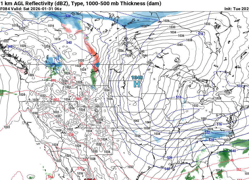
End of the NAM looks like it was about to do well! Just not far enough out if the vort would go neutral in time or not -

The “I bring the mojo” Jan 30-Feb 1 potential winter storm
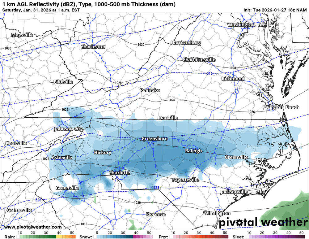
wncsnow replied to lilj4425's topic in Southeastern States
.thumb.png.b737f4bd779a0b7b5f3a6028971dd56a.png)
-

The “I bring the mojo” Jan 30-Feb 1 potential winter storm
lilj4425 replied to lilj4425's topic in Southeastern States
Well, don't leave me on a cliff hanger. What did it show? -
Prince George's is closed until Friday.
-

Winter 2025-26 Medium/Long Range Discussion
A-L-E-K replied to michsnowfreak's topic in Lakes/Ohio Valley
salvaging what we can from the duster pattern -
That's from 12z NAM Not like it matters, but 18z NAM looks east in its fantasy range
-
The “I bring the mojo” Jan 30-Feb 1 potential winter storm
ADB83 replied to lilj4425's topic in Southeastern States
I’m not going to mention the end of the NAM run because it’s hour 81 but I’m also not not going to mention it . -
The problem is that this lobe in trending weaker and north and east not stronger and west
-

The “I bring the mojo” Jan 30-Feb 1 potential winter storm
StantonParkHoya replied to lilj4425's topic in Southeastern States
I don't think you see the same result in CNC -
Lgt snow falling here. 19f.
-
same here minus the heavy wording.
-

E PA/NJ/DE Winter 2025-26 Obs/Discussion
zenmsav6810 replied to LVblizzard's topic in Philadelphia Region
low key-in. Thinking a glancing hit... no HECS -
Maybe, but the surface map looks like the Gfs and unlike other medium range models. Just sayin'.
.thumb.png.6b0c9e851c6d5e52b73901236ea07e6b.png)
.thumb.png.f99bba34995e50abe0e6f233f8d1a0da.png)
-
The “I bring the mojo” Jan 30-Feb 1 potential winter storm
wncsnow replied to lilj4425's topic in Southeastern States
This storm is really reminding me more and more of this one. The setup is quite similar. -
Reflective of recent guidance
-
The NAM at 84 was actually great for the recent storm
-
MoCo schools closed tomorrow and Thursday
-

Possible coastal storm centered on Feb 1 2026.
Typhoon Tip replied to Typhoon Tip's topic in New England
This may be at least partial as an effective management tool for some ... WPC Extended Forecast Discussion The ongoing settling of cold surface high pressure and additional surges in the wake of the historic winter storm will maintain dangerously cold temperatures for the central and eastern U.S. well into next week as per the Climate Prediction Center. The airmass may be more prolonged in areas with widespread snow/ice coverage and enhanced radiational cooling. Amplified mean troughing aloft will meanwhile bring rounds of weak to moderate clipper system snows from the north-central U.S. to the Great Lakes. In this anomalously cold pattern, there is potential for wintry precipitation into the Gulf Coast states late week as upper trough translation leads into northern Gulf frontal wave genesis. Wave progression downstream and trough/closed low development aloft is now increasingly likely to set the environment to produce a significant Eastern Seaboard Coastal Winter storm expected to rapidly deepen while lifting over the western Atlantic off the Southeast Saturday and Mid-Atlantic/New England Sunday. Uncertainty has improved but remains with the exact track of the low which impacts the onshore wintry precipitation focus and footprint. However, the growing consensus at this time is for heavy snow potential from the eastern Carolinas/Mid-Atlantic through coastal southern New England. The forecast strength of the deep low suggests high winds/waves and coastal flooding would also be expected. -
https://x.com/weathertrackus/status/2016247539130138969?s=46&t=LVg8BRWCh1zZb6F_t95EVg .


.png.1c6d165e024847425ba70a6e86e1a272.png)


.png.ce0d41c5a865a191d2284c34ddf477e2.png)
.png.856b13bb07786f476d9f28d80be94142.png)


