All Activity
- Past hour
-

Richmond Metro/Hampton Roads Area Discussion
Conway7305 replied to RIC Airport's topic in Mid Atlantic
no, I just copied and pasted it from I mean thread -
i had to talk half of the neighborhood ladies brigade text group of the ledge this morning.
-

January 25-26 Winter Storm Potential
anthonyweather replied to Ralph Wiggum's topic in Philadelphia Region
EURO ENS are much better than 00z -
DLH Area Forecast Discussion National Weather Service Duluth MN 1248 PM CST Tue Jan 20 2026 .KEY MESSAGES... - Brutally cold temperatures are expected through the weekend, with multiple days below zero Thursday through Sunday. Low actual temperatures in the negative 30s to 40F, and minimum wind chills in the negative 30s to 50s. The coldest days will likely be Friday and Saturday. - A couple areas of light snow pass over the region this evening through the day Wednesday. Accumulations of an inch or less are expected. - Light lake effect snow and clouds may persist along the South Shore through the weekend. && .DISCUSSION... Issued at 1243 PM CST Tue Jan 20 2026 Relative to the last couple days and the coming days, today and tomorrow will be fairly "mild" (in a northern mid winter sense). High temperatures above zero are expected this afternoon and Wednesday - with some folks seeing afternoon temperatures in the teens tomorrow! This temperature moderation is occurring thanks to some WAA ahead of a couple passing upper level vort maxes spurring on some weak surface clippers. These will pass through this evening through Wednesday bringing a couple areas of light snow. The first passes through this evening, mostly from Brainerd to Hayward. The second should move across the area from northwest to southeast through the day Wednesday with a little wrap around snow lingering into Thursday morning. Total accumulations should be around an inch or less across the region. Behind the Wednesday clipper, a hefty cold air mass is expected to drop into the Northern Plains, Midwest, and Great Lakes region through the weekend with 850mb temperatures dropping into the -30s Celsius. This is expected to result in several days of some very cold surface temperatures beginning Wednesday evening through at least Sunday midday, when temperatures are unlikely to rise much above zero, if at all. The coldest days of this period are expected to be Friday and Saturday. Thursday and Friday, brisk northwest winds are expected which will lead to the coldest winds chills of this period Thursday night into Friday morning. Wind chill values of -40 to -50F are possible. The coldest actual air temperatures are expected Friday night into Saturday morning when widespread temperatures of -30 to -40F are forecast. There is a 5 to 10% chance that some of the local coldest spots could drop to -50F actual temperature on Saturday morning. With these cold temperatures and high confidence in them occurring, we`ve issued a plethora of cold weather headlines with this forecast update. For Wednesday evening into Thursday morning/midday, we`ve gone ahead and issued a Cold Weather Advisory for much of the area, with an Extreme Cold Warning along the far north. The Borderlands warning and the advisory along the Iron Range/North Shore continue through the day on Thursday as any diurnal warming is expected to be minimal. Thursday evening, the whole area falls into a Extreme Cold Watch through midday Saturday. Sunday and Monday mornings will likely feature more Cold Weather Advisories but shouldn`t be as brutally cold as Friday/Saturday. Looking ahead to next week it appears we`ll moderate slightly but still be below normal. There are little to no chances of snow after tomorrow`s clipper, outside of the South Shore possibly getting some on/off lake effect with the northwest winds and cold temperatures. Global models show a slight chance of snow returning mid next week as slightly warmer temperatures allow moisture back into the area.
-

2025-2026 Fall/Winter Mountain Thread
Maggie Valley Steve replied to Buckethead's topic in Southeastern States
I've got to say, that was probably the best AFD from GSP I seen since just before Helene. Obviously this is an all of Government event from the local, County, State and Federal. Every meteorological asset we have is being thrown at this upcoming event. I expect some big changes ahead the next coming days in regards to modeling with the RECON data being assimilated. -
I got my KU book signed by him years ago. Great dude.
-

Possible Record Breaking Cold + Snow 1/25 - 1/26
wishcast_hater replied to TriPol's topic in New York City Metro
Just heard 1010 WINS mentioning a storm system for this weekend but misses us to the south. SMH. I guess its possible and then mass suicide would be occuring on this board. -
And it begins..WSW up now TX, AR, LA
-
because a 1031mb high in Tennessee always works out for us
-

Central PA Winter 25/26 Discussion and Obs
mahantango#1 replied to MAG5035's topic in Upstate New York/Pennsylvania
DT: ✳️ CRITICAL UPDATE ON JAN 24-25 EVENT-- and the Tuesday 12z OP- GFS MODEL RUN... ✳️ ...... For the love of God will somebody please fix this appallingly bad model?... The Tuesday 12z GFS / GFS AI model again for some reason sinks the whole system southward -- to the point where gotten to the point of almost no snow in DC to NYC . I have said this before many times--the GFS model is trash for East Coast winter storms beyond 78 hrs . It always over does the cold air, shows suppressed system and always has storms move off the coast. Then once are within 72 hrs we see the pathetic .., " IT IS TRENDING NORTH !!!... I can pull up the GFS Models runs from days before January 2016 ... February 2014 ... December 2009 ... February 2010 ... 9 December 2018 .... and time after time after time the GFS model ALWAYS does this. ▶️PROOF? the 12Z Tuesday OP GFS & GFs AI models dont match its own ensembles. ◀️ Look I know there are folks out there that think I take the giant dump on the GFS model for with East Coast winter storms for no reason or because I simply don't like the solution. Well I don't live in Washington DC or Baltimore Philly so it this has nothing to do with what I want. It is a bad model Beyond 78 hours when it comes to East Coast winter storms. Always has been and then probably always will be. ⚠️ Finally the crappy GFS model actually INCREASE uncertainty especially for meteorologists that don't look at ensembles or people who are just weather presenters. ⚠️ You have one solution of 12 inches and then another model which gives a solution of under 2 inches. This sort of ridiculous variance is useless in forecasting. I mean what's the weather forecast going to be? ....Partly cloudy chance of snow with accumulations between 0 to 12 inches?... #Winter2026 #SnowLovers #MidSouthWeather #SoutheastWeather #MidwestWeather #EastCoastWeather #Snowfall #IceStorm #Snowstorm #wxtwitter #vawx #mdwx #wvwx #dcwx #pawx #phlwx #rvawx #ncwx #rduwx #njwx #mass #ctwx #nywx #nycwx #ohwx #indwx #kywx #tnwx -
Sitting in Winston-Salem feels like a good spot. Obviously gonna be some ice in there, but should get a decent front end snow. It’s been a while. It’s going to be fun.
-

Possible Record Breaking Cold + Snow 1/25 - 1/26
MANDA replied to TriPol's topic in New York City Metro
Only difference is that was a coastal bomb with very intense deformation banding for hours mid and late storm. This upcoming event is not really a synoptic comparison. At least not at this time. Get the full energy out of the SW and a complete, clean phase then all bets might be off. No matter what, we have a legit threat of something late weekend into early next week and for me half the fun and excitement is in the tracking.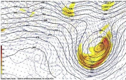
-
Wow the U of KU himself??? That is awesome!
-
GFS is snow and Euro is ice.
-
I know its Tuesday, but ball park start time? I'll be coming home Sunday afternoon with two coach buses full of 100+ high school kids from Hebron NH headed to Medway MA.
-
I don't know ow about that especially if it brings a chance of ice into Magnolia Delaware.
-

1/23/26-1/25/26 Winter Storm Thread
Holston_River_Rambler replied to AMZ8990's topic in Tennessee Valley
As far as I know I can share: 12z para CMC: 12z on the right -------> 0z on the left: -
Its the northern stream effing us last minute
-

Central PA Winter 25/26 Discussion and Obs
Itstrainingtime replied to MAG5035's topic in Upstate New York/Pennsylvania
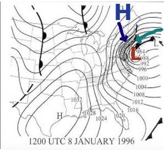
1996 I started with a temp of 10. I got to 20 at the height of the storm. -
Ice
-
1940? Well dang Baltimore must've gotten skunked then because BWI recorded 9.8 inches on the month, lol
-
NWS is forecasting 3 consecutive nights in the -30s at INL...and it will probably hit the -40s in the radiator spots of Tower and Embarrass if winds go calm. Wednesday A 40 percent chance of snow, mainly before noon. Mostly cloudy, with a high near 11. Light and variable wind becoming northwest 5 to 10 mph in the morning. Winds could gust as high as 20 mph. Wednesday Night Partly cloudy, with a low around -23. Wind chill values between -25 and -35. Northwest wind 5 to 10 mph, with gusts as high as 25 mph. Thursday Partly sunny and cold, with a high near -14. Northwest wind 5 to 10 mph, with gusts as high as 25 mph. Thursday Night Mostly cloudy, with a low around -30. Northwest wind 5 to 10 mph, with gusts as high as 20 mph. Friday Mostly sunny and cold, with a high near -14. West wind 5 to 10 mph, with gusts as high as 20 mph. Friday Night Partly cloudy, with a low around -38. West wind around 5 mph becoming calm in the evening. Saturday Mostly sunny and cold, with a high near -9. Calm wind becoming southwest around 5 mph. Saturday Night Partly cloudy, with a low around -30. Calm wind. Sunday Mostly sunny and cold, with a high near -2. Calm wind becoming west around 5 mph in the morning.
-
Upstate SC ?
-
More watches popping down in the plains. Can’t wait to see the map light up over the next couple days. There’s going to be a ton of people under winter headlines.
-

Texas 2026 Discussion/Observations
aggiegeog replied to Stx_Thunder's topic in Central/Western States
Followed by Tulsa and SHV.


