All Activity
- Past hour
-

Augdewst 2026: Summer's Last Stand
vortex95 replied to Prismshine Productions's topic in New England
That's pretty good. Just thinking that in the summer, it not easy to snow in the tropics even at 14,000 ft, but even less likely when a TC is present b/c of its warm core nature, but PHTO sounding 16/00z showed it right at 0 C at this level. -
 order viagra and cheapest viagra Cheap Viagra 100mg https://www.google.com.ph/url?q=https://mencarevirtual.com cheap viagraor https://boyerstore.com/user/fzoxwdsehy/?um_action=edit Sildenafil 100mg price [url=http://infosmi.com/redirect.php?url=http://mencarevirtual.com/]Viagra tablet online[/url] Cheap generic Viagra onlineand [url=https://kamayegaindia.com/user/lnfrnnaycz/?um_action=edit]Cheap generic Viagra[/url] viagra without prescription
 -
We managed 0.02” yesterday to bring our August total to 0.15”
-

Central PA Summer 2026 Discussion/Obs Thread
mahantango#1 replied to Voyager's topic in Upstate New York/Pennsylvania
.42 so far today. -
1630z OTLK from SPC disco for our area While storms have weakened, showers/cloud cover remain prevalent near/east of the Appalachians at midday across the Mid-Atlantic region. This will tend to limit/delay destabilization in many areas (especially with north-northeastward extent). That said, air mass recovery/advection is expected from the west, with ample upstream clearing per visible satellite imagery across the Cumberland Plateau into parts of the Allegheny Plateau. Pending the timing/location of destabilization, some terrain/lee trough-related development may diurnally occur, although the most prevalent/more certain scenario may be for potentially severe storms to spread into the region this evening. Damaging winds will be the most common hazard regionally, although a tornado could occur, attributable to MCV-enhanced flow and/or with any storms interacting with the effective warm front across the Mid-Atlantic region.
-
2nd batch actually produced enough rates to wet the ground. .25" on the day.
-
Thanks! Great to know and I will pass along. Turning off the NAM I have no issue w/, but when you roll out a new model, you should always keep its predecessor for a time for comparison. The NAM is severely outdated, but the HRRR is not and still does a solid job, so kept it UFN! They were supposed to stop the HWRF and HMON last year, as the HAFS has shown marked improvement overall (I was sold when it nailed MIlton's RI, then weakening, then another RI, and then its rapid weakening leading to landfall). The HMON?. recall when that was first rolled out in 2017 I think. It was showing crazy intense TCs, so much the model fields would "turn inside-out" b/c the intensity was nuts. But the HWRF and HMON continue. I prefer avoid the notion "more is better." Yes, second options and consensus have value, but only to a point. It can easily become TMI and hurt the fcst process. Also, you have those that always look for the one model that shows the worst case scenario, and they run w/ that for clicks/likes on social media, when it is well known X model is terrible or has bias for Y phenomena. It's like the GFS for spinning up bogus TCs beyond day 7 or the ICON in just how it handles TCs (much too intense forecasts for current TCs).
-
Any idea why 1630z OTLK from SPC is late? I'm checking kamala and SPC... I don't see it
-
Had a surprising fog this morning north of Kernersville. I'd give it a scale of 3 out of 10 when I got up about 7:45.
-
The part about the RAP is interesting to me because it seems like SPC Mesoanalysis is created using the RAP. I wonder how much work it is to change all that over unless something else replaces it like WoFS. Edit: I guess they did it in 2012 with the RUC
-

Central PA Summer 2026 Discussion/Obs Thread
Blizzard of 93 replied to Voyager's topic in Upstate New York/Pennsylvania
Same in Marysville. -

Spring/Summer 2026 Pattern Discussion Thread
jaxjagman replied to Carvers Gap's topic in Tennessee Valley
93 right now,not sure we will hit triple digits,but should make a decent un at it,unlike yesterday there are no clouds today -
Next little batch dropped 0.06 up to 0.19 so far
-
Hey guys...is there any connection between s Super Niños and more mushrooms growing? Just curious...the one and only time I ever saw them grow in my front yard was December 2015. And now this year I'm seeing more of them than usual around the city/county.
-
Here is the best line I have seen that tempers the idea that the models are so good, they are better all the time by default, and by extension, human input is not needed. "Models now can give very precise-looking forecasts/output that can be *precisely* wrong! And going one step further: "Precision does not mean accuracy!"
- 1,926 replies
-
- 1
-

-
- severe
- thunderstorms
- (and 7 more)
-

2026 Mid-Atlantic Severe Storm General Discussion
wxmeddler replied to Kmlwx's topic in Mid Atlantic
The over-convection and "big blobs" on the RRFS is a known bias or "bug" with the FV3 Dynamical Core. This was explored recently by Lou Wicker at OU (See: https://doi.org/10.1175/MWR-D-25-0230.1). In short, it can't really be fixed without significant changes to the core. OMD hasn't said it outright publicly but the original plan was to turn off the HRRR and RAP at the same time as the RRFS Operationalization. But they've scrapped that specifically because of the FV3 core issues. Now the plan is to turn off the HRRR and RAP when the RRFS transitions to the MPAS Core in ~2028. (https://www.weather.gov/media/wrn/calendar/RRFS_webinar_20260625.pdf)- 1,926 replies
-
- 2
-

-

-
- severe
- thunderstorms
- (and 7 more)
-

Central PA Summer 2026 Discussion/Obs Thread
canderson replied to Voyager's topic in Upstate New York/Pennsylvania
A gully washer in HBG - Today
-
That's a solid sign. One thing that can misleading -- cool, dreary, and stable-looking can make ppl think, "how can this 'go away' so fast and big svr occur?" Well, it does and can be quite dramatic. Wichita Falls TX was socked in stable ahead of the warm front on 4/10/1979, and then an F4 cut directly through the city for the costliest tor up to this time. Same thing in Windsor CO on 5/22/2008. This was an odd one b/c it occurred the late morning, moved NNW, and the storm formed in a very narrow sweet spot of instability/shear ahead of a sfc low. See here: https://www.weather.gov/bou/TornadoMay22nd2008 Mean-looking! https://www.youtube.com/watch?v=GfYuT0oalXQ
- 1,926 replies
-
- 1
-
-
- severe
- thunderstorms
- (and 7 more)
-
South of there. We may get some downpours tonight
-
Good demonstration of how more resolution is not always automatically "better." There's probably a "happy medium" where errors can be smoothed while still having good resolution...but I imagine if we had like 0.25km resolution models it would be chaotic at best. Until better computing comes along I guess.
- 1,926 replies
-
- 1
-
-
- severe
- thunderstorms
- (and 7 more)
-
It loves to make giant convective blobs on its composite reflectivity fcst. Once it goes operational, and ppl use it more, I bet that will be a sig complaint, and they will address it. A big issue w/ mesoscale models now is that the more hires they get and more directly simulate the atmosphere processes, the challenge to get everything in balance goes up in a non-linear fashion. In other words, any small tweak to fix one issue can have big impacts to another part of the model.
- 1,926 replies
-
- 1
-
-
- severe
- thunderstorms
- (and 7 more)
-

2026 Mid-Atlantic Severe Storm General Discussion
batmanbrad replied to Kmlwx's topic in Mid Atlantic
CSU-MLP latest still painting the maximum TOR possibilities right over the general DC area: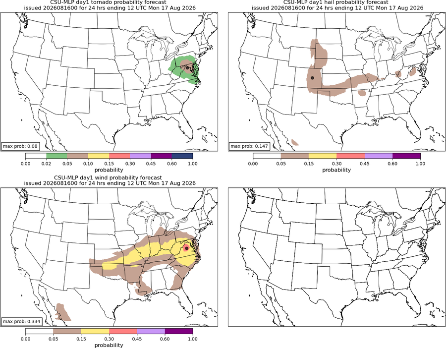
- 1,926 replies
-
- 3
-
-
- severe
- thunderstorms
- (and 7 more)
-

Spring/Summer 2026 Pattern Discussion Thread
John1122 replied to Carvers Gap's topic in Tennessee Valley
The DP is 78 right now as we approach the noon hour. This went from a drought to the most humid summer I can recall here. -
The RRFS looked pretty good too. I feel like it has tended to be very bullish on convection this season.
- 1,926 replies
-
- 1
-
-
- severe
- thunderstorms
- (and 7 more)
-
Short range models still showing mostly south jersey for severe threat later?




.thumb.jpg.a628c2147efdff1c820341d5143d9237.jpg)