All Activity
- Past hour
-
Happy Birthday. Appreciate that detailed write-up; it makes the kick to the nuts easier to accept.
-

July 2025 Obs/Disco ... possible historic month for heat
OceanStWx replied to Typhoon Tip's topic in New England
X and I were just looking through that. Sure seems like SPC needs to hop on expanding that. -

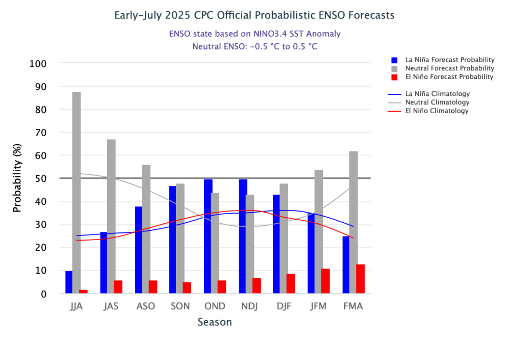
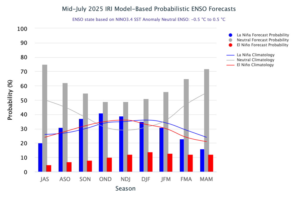
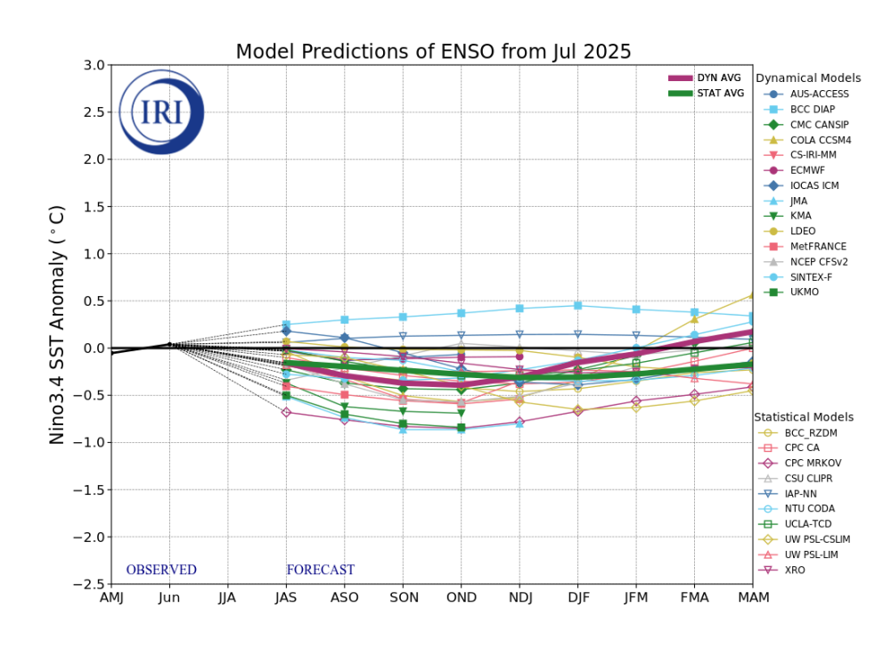
2025-2026 ENSO
michsnowfreak replied to 40/70 Benchmark's topic in Weather Forecasting and Discussion
1916-17 is one of the few winters that I've never looked too deep into. Just glancing it looked cold and white, with snowfall a bit below avg but good enough for lasting deep winter. -
2025-2026 ENSO
michsnowfreak replied to 40/70 Benchmark's topic in Weather Forecasting and Discussion
Sweet Jesus what a dataset lol. He must be trying to get a jump on JBs subscribers. -

2025-2026 ENSO
Stormchaserchuck1 replied to 40/70 Benchmark's topic in Weather Forecasting and Discussion
I guess 1916-17 is his only one that makes sense. It was a -PNA Winter though, way below average in the West and Upper Midwest, average in the SE and Mid-Atlantic (vs 1900-2000 averages). -
But 1916-7 was one of the most -PDO DJFs on record and 1917-8 averaged neutral.
-

July 2025 Obs/Disco ... possible historic month for heat
powderfreak replied to Typhoon Tip's topic in New England
A below normal minimum coming up. We knew you had it in you, Mother Nature. 54F currently and normal low is 55F.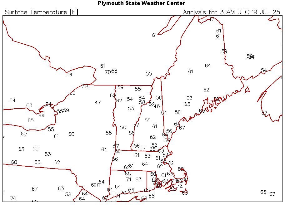
-
I was bitching the minute I stepped foot outside at BWI. Home sweet home!
-
Only made it to 74 next to the lake today. Absolutely perfect and felt so refreshing. Not sure what to really make of tomorrow but hoping to at least have a rumbler roll on by.
-

July 2025 Obs/Disco ... possible historic month for heat
CoastalWx replied to Typhoon Tip's topic in New England
A touch of violence on the Nam and hrrr for late Sunday. -

July 2025 Discussion-OBS - seasonable summer variability
FPizz replied to wdrag's topic in New York City Metro
Yeah 66 here now. 81 at Newark, lol -
2025-2026 ENSO
Stormchaserchuck1 replied to 40/70 Benchmark's topic in Weather Forecasting and Discussion
^lol, he's basically talking about a +PDO. -
Wow man I wish I could spend a week with you putting me to work learning everything you know. Forget meteorology. This stuff is far better!
-

2025 Atlantic Hurricane Season
Floydbuster replied to BarryStantonGBP's topic in Tropical Headquarters
I wonder if this season will be like 1998, 1999, 2004, 2017. Normal slow June and July and then the real activity starts in August. The last several seasons have had some oddball stuff like strong July activity, slow August activity, and prolonged Cape Verde activity into October. -
From WB’s Joe D’Aleo today: That warm water east of Japan will move east in the North Pacific current north of the North Pacific Gyre. How much warmth will be carried east before the winter is something we will need to monitor. If it ends up staying more in mid-ocean, a very different winter story would evolve. This is just a heads up. When warm water in the Pacific has settled in the northeast Pacific, winters are brutal. Examples include 1976/77, 1977/78, 1993/94 and 1916/17, 1917/18 and 2013/14, 2014/15/ Those back to back cold winters turned the trend negative for 1996 to 2015. The winter snows also set records.
- Today
-
Extreme heat stays out west. We Texans will take the high heat in order to help out all our friends back East. We are sending you DCers many a cool, dry front laden with dry continental air!! We like it hot. We'll gladly take ALL the oppressive dewpoints! I am pretty used to 77 dewpoints by now!
-

2025-2026 ENSO
PhiEaglesfan712 replied to 40/70 Benchmark's topic in Weather Forecasting and Discussion
-
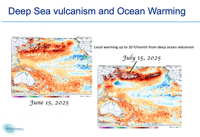
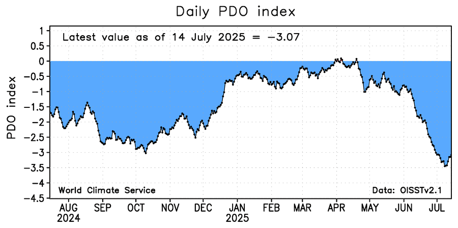
Today posted by Joe D’Aleo: Dr Viterito reported a new geothermal "hot spot" has emerged over the past 2 weeks, and it appears to be heating up the Kuroshio Current in the Pacific. Specifically, the Wilber 3 System has catalogued 76 seismic events since 6/21 off of the southern coast of Japan. The area impacted is a hydrothermal vent field to the west of the Ryukyu Islands, in an oceanic region known as the Okinawa Trough. See how the surface water has warmed in recent months: I was wondering if the recent very steep PDO drop started on 6/21/25. However, that actually started 6/8/25 rather than 6/21/25. By 6/21/25, the WCS daily PDO had already plunged to -2 from -1 as of 6/7/25:
-

July 2025 Discussion-OBS - seasonable summer variability
lee59 replied to wdrag's topic in New York City Metro
Still 81 at Newark, down to 70 here. -
It’s suppose to be be better early next week. You’ll be here on Monday bitching and all of us will be saying how nice it is.
-
Congrats Dale City! You are leading the Nation in rain for the year so far!!!!!!! You passed 33 inches! I am jealous as all hell!!! All I have so far this year, is 26.3 measly inches of rain. I got 6.5 inches in a week but I wanted that 12 inch lolli SO DAMN BAD, I could taste it!
-
2025-2026 ENSO
Stormchaserchuck1 replied to 40/70 Benchmark's topic in Weather Forecasting and Discussion
^Decadal trends are real. Some people don't get that for some reason. The Earth seems to move in waves, that are decades long. Now with all this data in 2025 we can map out the NAO/PDO and see that the standard deviation of random vs cycles is about 5:1 (5x more likely to be cyclical). The Earth is warming an average of 3-4F. ok. I don't think that applies to everything, and large scale patterns recently. The problem with data-analysis right now is that we might be in the middle of the -PDO/+NAO cycle, seeming like it's a one-way trend (with regards to the most talked about subject - Winter Northeast snowfall). -
Happy Birthday man!!!!
-
Ironically the last two days we've been under a flood watch with an 80 percent chance of rain and it's hardly rained at all.
-

July 2025 Obs/Disco ... possible historic month for heat
HoarfrostHubb replied to Typhoon Tip's topic in New England
Also, possibly checking out that brewery that moved into Hitchcock’s old space on Sunday.


