All Activity
- Past hour
-
Eps, as usual, are a miss tonthe north for the 8th/9th.
-
Lock it in! I can't remember the last event that RDU came in with 6 or greater. December 2018 might be it.
-
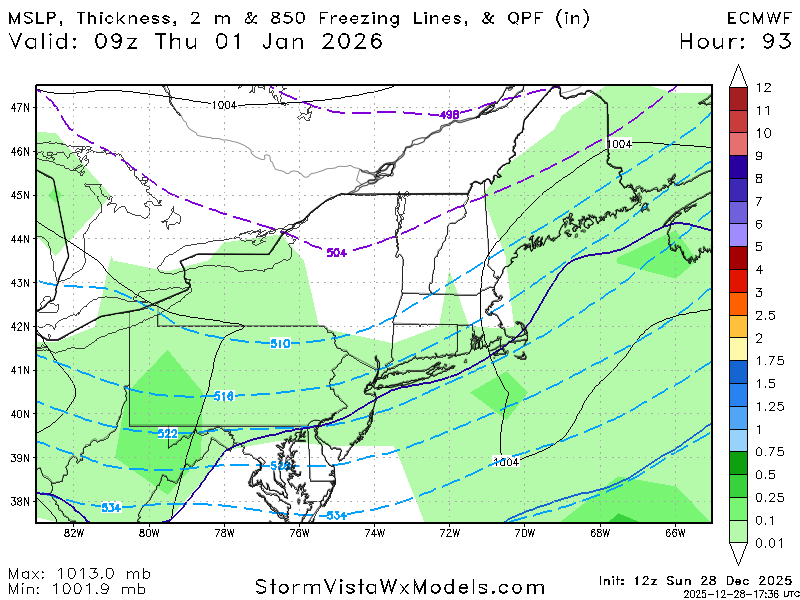
As mentioned by other posters the time period after this particular storm signal look to be more promising but I really cant help but like this depiction for the 4th. We have a good amount of vorticity to our south, a block to our north, and surface low pressure across Georgia in a position to bring in both gulf and Atlantic moisture. Of course, as depicted the bowling ball to our north would suppress the storm but for a week out I really can't hate it. We just need to see the trends but as it currently stands it is more than trackable.
-

Boxing Night Snow/Sleet/Ice Dec 26-27 Storm Thread/Obs.
The Iceman replied to Mikeymac5306's topic in Philadelphia Region
Speak for yourself, I got my only underage drinking charge at a bowling alley -
After reaching an eye-popping 75 degrees yesterday, Greensboro is in the 30s this afternoon
-
Yea this was a heavy dense snow.
-

Ice Ice Baby December 28-29 Storm Discussion
VivaManchVegas replied to Baroclinic Zone's topic in New England
We rebounded to 38 from a low of 6. Impressive. Milky sky. Revised GYX forecast had us topping out at 36. Sundown temperature of 32. Calling for about 0.4" of freezing rain followed by 37 degrees and 0.25" of rain, hopefully enough to minimize the power outage threat before the winds move in tomorrow night. -
Explosive pattern on the models in early to mid January with a nice ridge out west and lots of blocking. The STJ is also waking up.
-
Explosive pattern on the models in early to mid January with a nice ridge out west and lots of blocking. The STJ is also waking up.
-

E PA/NJ/DE Winter 2025-26 Obs/Discussion
Birds~69 replied to LVblizzard's topic in Philadelphia Region
Getting screwed is a possibility in our area at all times. Just check radar and check surrounding stations is all we have. Any sort of virga sucks and should be illegal say only weenies....
-
Now, I look at this map, and everything kind of fits and makes sense. There isn't a lot of feedback (edit, well the NAO is pretty strong). The -NAO is still there. The trough on the West Coast probably wants to slide east...and then a western ridge "should" rebuild right after it. That is perfect placement for an NAO. Any low road slp w/ that block in place has to be watched. That is a very good look in my book.
-

Ice Ice Baby December 28-29 Storm Discussion
ineedsnow replied to Baroclinic Zone's topic in New England
Meh on qpf.. can't get ice without that -
Right,the MJO right now you should look at whats driving the pattern,even the ensembles havent been very good in the long range this winter,its been a weird winter sorta speaking
-

Ice Ice Baby December 28-29 Storm Discussion
Modfan2 replied to Baroclinic Zone's topic in New England
Not sure, @CT Rain posted not too long ago and sees potential still overnight;you have a better shot than most -

E PA/NJ/DE Winter 2025-26 Obs/Discussion
RedSky replied to LVblizzard's topic in Philadelphia Region
No but it will manage to virga until it's dark and hits 33F -
If that EPO ridge hits and holds around Jan 10th, I think we are in business. Dec 28-10th has always seems kind of like a back and forth pattern to me. But yeah, modeling is just wild right now. I would suspect during the second half of January, we possibly could see some very cold weather if not before then. Right now, when I see model feedback(deep reds or deep blues), that run is toast from that point forward...but still fun to watch. With that NAO block in place, really anything after Jan 2nd is fair game to track. I am just hanging out and watching the LR pattern until we get to that point. Depending on which model and which run...this could be a really wild pattern or a dud. I have no idea which...but I lean towards cold and stormy the deeper into January that we get. With models struggling to "see cold," my money is they aren't seeing some cold fronts right now. As for the MJO, low amplitude and all over the place. I am not sure it will drive the bus for a bit. I am banking on the QBO and HL blocking running the show. As long as we don't stall in 6, I think we can over-ride it. The good thing is that we are likely exiting the chinook pattern tonight when that howler of a cold front announces its arrival....
-
E PA/NJ/DE Winter 2025-26 Obs/Discussion
Birds~69 replied to LVblizzard's topic in Philadelphia Region
No nap required either... -
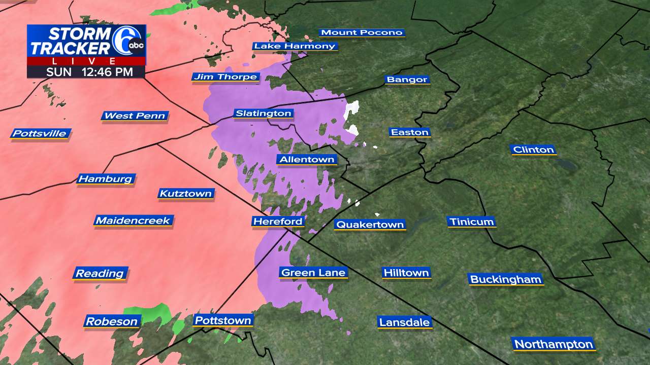
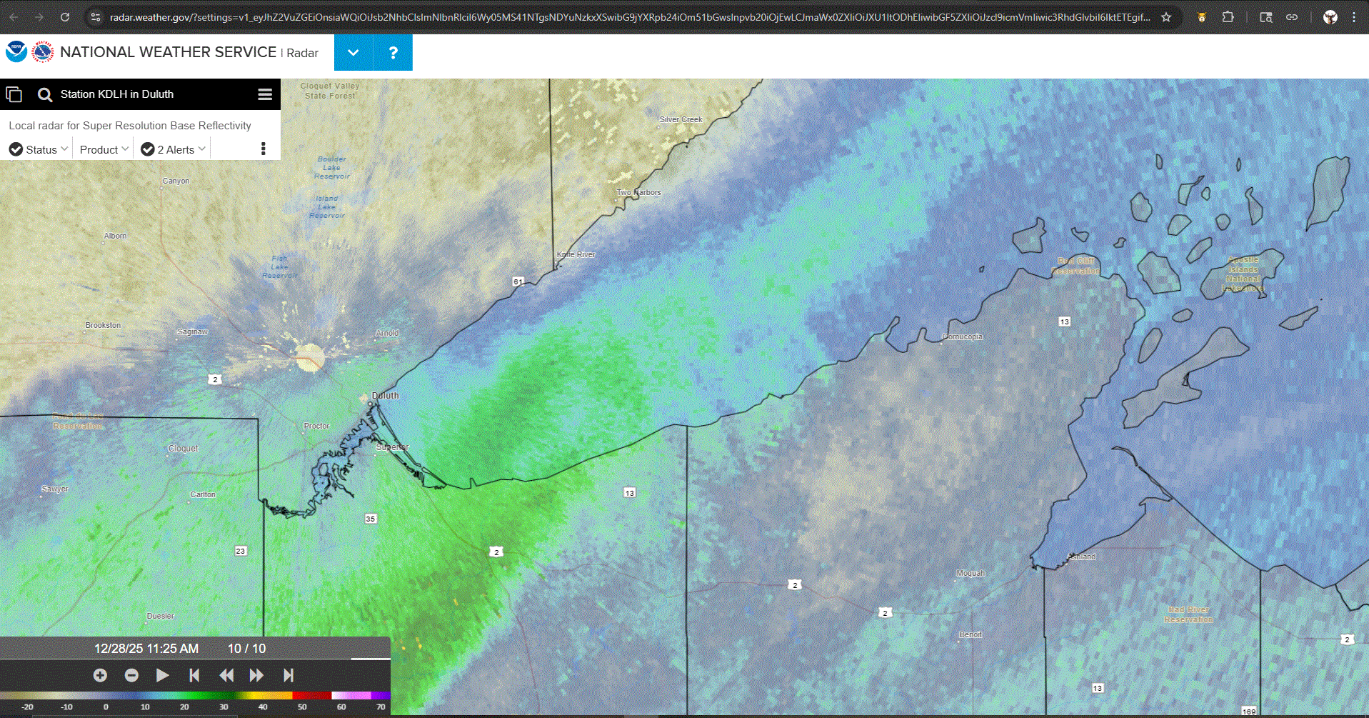
Getting robbed. Snow staying just offshore, but is filling in around DLH. Just FL here in TH. Was expecting this possibility. We'll see if it fills in a little more as the day wears on, and I get something to measure tonight.
-
Mood flakes
-
E PA/NJ/DE Winter 2025-26 Obs/Discussion
Birds~69 replied to LVblizzard's topic in Philadelphia Region
Some mixed crap during the Birds game would be icing on the cake to this already wintry scenery/night holiday outdoor light season. Lazy people are missing a nice stroll at night with Christmas lights on.... -
Tomer stated the following today, " While a major snowstorm is never a guarantee, chances of at least one or two in the January 8-25 time frame are higher than average. "
-
Ice Ice Baby December 28-29 Storm Discussion
ineedsnow replied to Baroclinic Zone's topic in New England
28.6 warmed up quick today. Looks meh for ice -
Glad I decided to take down the outdoor Christmas decorations today.... District of Columbia-Frederick MD-Carroll-Northern Baltimore- Cecil-Southern Baltimore-Prince Georges-Anne Arundel-Charles-St. Marys-Calvert-Northwest Montgomery-Central and Southeast Montgomery-Northwest Howard-Central and Southeast Howard- Northwest Harford-Southeast Harford-Nelson-Albemarle-Greene- Madison-Rappahannock-Fairfax-Arlington/Falls Church/Alexandria- Northern Fauquier-Western Loudoun-Eastern Loudoun-Northwest Prince William-Central and Southeast Prince William/Manassas/Manassas Park- 1211 PM EST Sun Dec 28 2025 ...WIND ADVISORY IN EFFECT FROM 9 AM MONDAY TO 1 AM EST TUESDAY... * WHAT...West winds 20 to 30 mph with gusts up to 50 mph expected. * WHERE...Portions of DC, central, north central, northeast, northern, and southern Maryland, and central, northern, and northwest Virginia. * WHEN...From 9 AM Monday to 1 AM EST Tuesday. * IMPACTS...Gusty winds will blow around unsecured objects. Tree limbs could be blown down and a few power outages may result.
-
Up to 50 here with southernly winds. Hammer drops tomorrow morning.
-
Dont be a weenie You cant be serious