All Activity
- Past hour
-

2025 Atlantic Hurricane Season
BarryStantonGBP replied to BarryStantonGBP's topic in Tropical Headquarters
That means gabby should pack it up wait for storms after her innit - Today
-
When I was a little kid I remember shuffling the water around in the bathtub to simulate a boat in the middle of a raging storm. Needles to say, big momma was never pleased afterwards.
-
Hey GBM September's right around the corner - Its high time for a massive hurricane yarn on Sep 1.
-
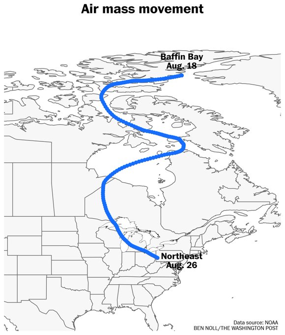
starting to get reeeeaaaalllly bored............. 300 FXAK69 PAFG 262214 AFDAFG Northern Alaska Forecast Discussion National Weather Service Fairbanks AK 214 PM AKDT Tue Aug 26 2025 .SYNOPSIS... A series of disturbances will continue to keep the western half of Alaska cool and wet through the end of the week. Localized flooding throughout the Brooks Range will remain a concern for the next few days as streams and rivers continue to rise as a result of recent heavy rainfall. Meanwhile colder Arctic air will move onto the North Slope bringing the first signs of winter precipitation to parts of the Brooks Range and the Arctic Slope through Thursday. && .KEY WEATHER MESSAGES... Central and Eastern Interior... - Heavy rainfall will continue for the Dalton Highway summits and central Brooks Range through tonight with smaller rivers and streams potentially reaching flood stage. - Risk of flooding along the Dalton Highway will continue between mile markers 140 and 240 through early Wednesday. Additional rain accumulations through Wednesday are forecasted to be between 1" and 3". - Wind advisories are in effect for southerly winds gusting up to 60 mph through Windy Pass, 50 to 55 mph through Isabel Pass, and around 50 mph in Delta Junction. The most likely time frame is between this afternoon and Tuesday night. - Warmer temperatures and breaks in the cloud cover are possible Wednesday for Fortymile Country and the Upper Tanana. West Coast and Western Interior... - Precipitation will continue for the Western Interior through Wednesday, with additional rainfall ranging between 0.5" and 1.75". The heaviest amounts will be from Huslia, to McGrath, to Holy Cross. North Slope and Brooks Range.. - Snow has begun to mix in with the rain. Minor accumulation are possible tonight and Wednesday at the higher elevations along the Brooks Range from Point Lay to Anaktuvuk Pass. - A glaze up to 0.1" of ice is possible along Anaktuvuk Pass and the north side of the Brooks Range along the Dalton Hwy Corridor. This is expected to continue through Thursday morning. - Chances for wintry precipitation will continue across the Brooks Range through the end of the week. && .FORECAST ANALYSIS AND DISCUSSION... The overall weather pattern has not changed much over the past 24 hours with a persistent upper trough extending down through the Bering Sea with a dominant ridge over western Canada and SE Alaska. This has kept the steering flow from the south and southeast across central and western sections of the state allowing for additional northward transport of moisture and additional disturbances to help keep the soggy weather going. We will watch a surface low track north from the YK Delta up to near the Northwest Arctic coastline tonight and tomorrow. This should help focus most of the rainfall over the west coast and portions of the western interior with the central and eastern interior taking a break from most of the rainfall for at least Wednesday. The exception will be across the Central Brooks Range and Arctic slope where leftover precipitation will encounter a brief Arctic intrusion tonight and Wednesday resulting in a wintry mix of precipitation. Shortwave energy will begin to eject northeast out of the Bering Thursday and Friday bringing another period of rain to central and northern Alaska (however precipitation with this feature should be less intense than what has occurred the past several days). Saturday and Sunday should see a respite from recent storms as a deepening low shapes up over the Bering (more on this is included in the Extended Discussion below). && .FIRE WEATHER... Persistent light to moderate rain the past few days continues to keep fire weather concerns at a minimum across the region. Only portions of Fortymile county and the upper Tanana Valley have managed to escape the steady precipitation. However even in these locations min RH values managed to stay around 40 percent the past few days. Rainfall for the central and eastern interior will taper off a bit Wednesday but should return with another passing disturbance later in the week. && .HYDROLOGY... A river flood warning continues in effect for Slate Creek near Coldfoot, Alaska. The creek crested at 20.78 feet at 5:00 AM Tuesday and is expected to stay above flood stage tonight through Wednesday morning. In addition another flood warning was issued for the Dalton Highway between mile markers 140 and 240. AKDOT 511 and public reports indicated water over the highway while nearby gauges continue to show rapid rises on nearby streams and creeks. This is all due to between 3 to 5 inches of rainfall in the area the past 24 hours. Additional rain is also expected in the area tonight and early Wednesday. Meanwhile the river flood watch for the tributaries of the Koyukuk and Kobuk Rivers has been extended into Thursday afternoon as additional rain continues across the south slopes of the Brooks Range and the Upper Kobuk Valley. Rises along the main stem rivers is also expected overnight tonight and into Thursday morning. Of immediate concern will be the Koyukuk at Allakaket which will likely be cresting Wednesday night into Thursday morning. Some minor flooding or low areas around Allakaket will be possible. .EXTENDED FORECAST DAYS 4-7... The focus turns back towards the Bering to begin the extended period. By early Saturday models are highlighting a 980mb surface low entering the southern Bering Sea with high pressure centered over the Gulf of Alaska. As the low tracks northwards through the Bering during the day, the gradient will strengthen allowing for another round of strong southerly winds along the west coast. This will be accompanied by the onset of additional precipitation over the YK Delta Saturday evening which will spread northwards over the Seward Peninsula and the western interior by Saturday night and Sunday. Models are still having difficulty with resolving the eventual fate of this low as far as track and strength are concerned. While this has to potential to result in some coastal flooding, confidence remains low with that regard for now. Coastal Hazard Potential Days 3 and 4... A storm entering the southern Bering Sea will bring stronger south winds to the YK Delta Coast beginning Saturday. This system will be monitored for further impacts to the west coast of Alaska over the next few days.
-
 54 here currently; could have a shot at the upper 40s. Windows are wide open!
 -

2025-2026 ENSO
so_whats_happening replied to 40/70 Benchmark's topic in Weather Forecasting and Discussion
Looks like we circle 1-2-3 again coming up through the last 3 weeks of September, some even show 8 with the cool neutral look we currently have (we wlll see). Should open up the door for a handful of systems but where we go into October will leave us with clues going into winter. Definitely weird we would have a slow season if we are indeed in a Nina state as well as getting recurves typically not a normal occurrence of being in a Nina state and a cool ending to summer also does not add up either. -
Currently 53 here at Midnight on a hilltop. Probably 47-48 here in Morning with mid 40's Valley's. Cool but not coldest for this time of year. Record for August 26 in Pennington gap was 38 back in 1986.
-

2025 Spring/Summer Mountain Thread
chris21 replied to Maggie Valley Steve's topic in Southeastern States
48 here. Was 48 this morning also. -
 I saw another tonight - north northeast of me 9:30 ish.I wasn’t really watching the sky this time but happened to catch it. It probably is a busy sky this week if you can patiently watch. There is a lot of light pollution up here still (Mohonk area) so star gazing is kinda disappointing generally.
 -
According to some, we are at solar minimum lol
-
I got 0.02" which increased my August rainfall total to 0.05".
-
Low of 68 which is our current temp. Had a high of 85. Picked up .09" just after midnight. Expected low of 62 tomorrow morning. It's gonna feel nice out there.
-
Canaan NWR is 4 degrees cooler than last night at this time 37 vs 41.
-
 79 the high here, now 66
 -
Today’s Euro Weekly run not only has the most active 9/15-21 ACE yet, it is the 1st run with 9/22-8 and that is even more active than 9/15-21! It has the quietest Sep week as the 1st one and the noisiest week as the 4th one. That resembles Sep of 2024 somewhat because then the quietest weeks of ACE in Sep were the 1st (0) and 3rd (0) while the 4th had the noisiest by far with AN ACE (18.1). The 2nd had 6.1. Today’s EW ACE Sep progs vs very active 20 yr climo 1-7: 4.5 (.3) 8-14: 11.3 (.7) 15-21: 20.4 (1.3) 22-28: 22.4 (1.6) So, today’s vs climo is despite a very quiet 1st week and still BN 2nd week progging the 1st 4 weeks of Sept at 58.6, which compares to only 24.2 in 2024 and ~the active 30 year climo of ~60. To compare, look at what I posted on 8/27/24: Today’s Euro Weeklies could be nicknamed “A Tale of Two Seasons”: - Weeks 1-3 (9/2-22): remain only at ~50% of climo overall. These haven’t changed much for days other than a gradual decline. - Week 4 (9/23-29/new week “on the block”): the first forecast for that week is for 120% of climo and it follows the prior week’s modest 70%. So, it’s seeing some kind of sudden change. If it were a reversion to climo, it would be only at 100%, not 120%. Also, this is the first time there has been any week at 120%+ since the 8/16 run. Will be interesting to follow. @PhiEaglesfan712If this EW run were to verify closely, the ACE through 9/30 would be ~100 and keep the door open for a 140+ season total as 30% of Octs-Novs over the last 30 years were 40+.
-
Today’s Euro Weekly run not only has the most active 9/15-21 ACE yet, it is the 1st run with 9/22-8 and that is even more active than 9/15-21! It has the quietest Sep week as the 1st one and the noisiest week as the 4th one. That resembles Sep of 2024 somewhat because then the quietest weeks of ACE in Sep were the 1st (0) and 3rd (0) while the 4th had the noisiest by far with AN ACE (18.1). The 2nd had 6.1. Today’s EW ACE Sep progs vs very active 20 yr climo 1-7: 4.5 (.3) 8-14: 11.3 (.7) 15-21: 20.4 (1.3) 22-28: 22.4 (1.6) So, today’s vs climo is despite a very quiet 1st week and still BN 2nd week progging the 1st 4 weeks of Sept at 58.6, which compares to only 24.2 in 2024 and is ~the active 30 year climo of ~60. To compare, look at what I posted on 8/27/24: Today’s Euro Weeklies could be nicknamed “A Tale of Two Seasons”: - Weeks 1-3 (9/2-22): remain only at ~50% of climo overall. These haven’t changed much for days other than a gradual decline. - Week 4 (9/23-29/new week “on the block”): the first forecast for that week is for 120% of climo and it follows the prior week’s modest 70%. So, it’s seeing some kind of sudden change. If it were a reversion to climo, it would be only at 100%, not 120%. Also, this is the first time there has been any week at 120%+ since the 8/16 run. Will be interesting to follow.
-
Downright chilly outside right now. It was kind of a shock given it is still August. I am gonna have to dig a jacket out of the clock in the morning.
-
 Highs: EWR: 83 BLM: 81 TEB: 81 New Brnswck: 81 PHL: 80 ISP: 80 ACY: 80 LGA: 80 TTN: 79 NYC: 79 JFK: 78 * no intra hour highs (ridiculous)
 -
Just heard a couple raindrops on my roof. But is going to just miss me mostly.
-
remarkably, there is one shower in the entire Mid-Atlantic this evening, and it's right over my house.
-
don't know if this works but it should navigate somewhere https://moe.met.fsu.edu/cyclonephase/compare/25082612/index.html
-

2025 Spring/Summer Mountain Thread
Maggie Valley Steve replied to Maggie Valley Steve's topic in Southeastern States
Already down to 56 this evening after an absolutely gorgeous day with a high of 72. Looking like the cool Autumn like air continues into Labor Day and the first week of September. It appears that summer has come to an early end for the Mountains. The models are showing several strong early Fall cold fronts into the first several weeks of September!.thumb.gif.0d82846f1aea613e045c138bde55b6b1.gif)
-
I’m going to pretend it’s a cat 1 hurricane so I can trick myself into enjoying it
-
What's the link to that again? There's been a strong ensemble (EPS) signal for some type of low to develop off the coast this weekend. I have zero interest right now given the possibility that this just trends to some strung out mess that gets ejected OTS, but if there were a way to get some tropical or hybrid up this way (or at least rain), this could work. We meh for now.


.gif.160c86eb7926fde18359a6f4702e3010.gif)

