All Activity
- Past hour
-

Central PA Summer 2026 Discussion/Obs Thread
Superstorm replied to Voyager's topic in Upstate New York/Pennsylvania
Warnings posted . -
Was only like 10% monitoring today. Impressive to the NW. We'll see if it does anything here. I'm over in Odenton this weekend.
-

2026 Mid-Atlantic Severe Storm General Discussion
dailylurker replied to Kmlwx's topic in Mid Atlantic
Congrats everyone that got rain last week and again this evening. I hope to maybe hear some distance thunder later on as it passes to my north per usual lately. -

2026 Mid-Atlantic Severe Storm General Discussion
Eskimo Joe replied to Kmlwx's topic in Mid Atlantic
SPC nailed this one. Never sleep on NW flow events! -

Central PA Summer 2026 Discussion/Obs Thread
Blizzard of 93 replied to Voyager's topic in Upstate New York/Pennsylvania
It converged over Marysville. Heavy rain & high wind gusts. -

Central PA Summer 2026 Discussion/Obs Thread
mahantango#1 replied to Voyager's topic in Upstate New York/Pennsylvania
Lots of thunder and wind here. Might be basically over now .45 rain from the storms. Much needed rain. Who knows when we will have rain again. -
Severe Weather Statement National Weather Service Baltimore MD/Washington DC 525 PM EDT Sat Jun 6 2026 MDC013-021-043-WVC003-037-062215- /O.CON.KLWX.SV.W.0075.000000T0000Z-260606T2215Z/ Washington MD-Carroll MD-Frederick MD-Jefferson WV-Berkeley WV- 525 PM EDT Sat Jun 6 2026 ...A SEVERE THUNDERSTORM WARNING REMAINS IN EFFECT UNTIL 615 PM EDT FOR NORTHEASTERN WASHINGTON...NORTHWESTERN CARROLL AND FREDERICK COUNTIES IN NORTH CENTRAL MARYLAND...NORTH CENTRAL JEFFERSON AND EASTERN BERKELEY COUNTIES IN THE PANHANDLE OF WEST VIRGINIA... At 525 PM EDT, severe thunderstorms were located along a line extending from Carroll Valley to near Smithsburg to near Boonsboro, moving east at 40 mph. HAZARD...70 mph wind gusts. SOURCE...Radar indicated. IMPACT...Damaging winds will cause some trees and large branches to fall. This could injure those outdoors, as well as damage homes and vehicles. Roadways may become blocked by downed trees. Localized power outages are possible. Unsecured light objects may become projectiles. Locations impacted include... Frederick, Hagerstown, Thurmont, Emmitsburg, Municipal Stadium, Harry Grove Stadium, Ballenger Creek, Robinwood, Taneytown, Walkersville, Boonsboro, Smithsburg, Braddock Heights, Paramount-Long Meadow, Mount Aetna, Mount Lena, San Mar, Clover Hill, Discovery-Spring Garden, and Wolfsville. PRECAUTIONARY/PREPAREDNESS ACTIONS... For your protection move to an interior room on the lowest floor of a building. && LAT...LON 3966 7700 3937 7734 3946 7789 3972 7764 3972 7696 TIME...MOT...LOC 2125Z 267DEG 36KT 3977 7739 3964 7751 3950 7772 THUNDERSTORM DAMAGE THREAT...CONSIDERABLE HAIL THREAT...RADAR INDICATED MAX HAIL SIZE...<.75 IN WIND THREAT...RADAR INDICATED MAX WIND GUST...70 MPH
-

Junorch obs and discussion 2026
Damage In Tolland replied to Damage In Tolland's topic in New England
Whatever happens for SNE seems like it’s with that developing line in PA/ NY. That’s the one models blow up . They dissipate that storm in SE NY. We’ll see how it plays out -
Central PA Summer 2026 Discussion/Obs Thread
Superstorm replied to Voyager's topic in Upstate New York/Pennsylvania
That line looks wicked . -
Just got home in time- nice storm happening IMBY
-
The pollen is so disgusting right now. Would have left my windows open all day but it was just bad... ac is on. Edit: After mowing the lawn today, I told my wife if I was allergic to pollen, in the least, we would have needed an epipen.
-
Thunderstorm Warning just issued. Will see if the line holds or splits.
-
YouTube algorithm keeps throwing me daily DLR stuff. Full show at Keswick a few weeks back (5/19/26). Band isn't bad but he can't sing worth a damn...
-

Central PA Summer 2026 Discussion/Obs Thread
Jns2183 replied to Voyager's topic in Upstate New York/Pennsylvania
This a painful miss. Going to converge just east of river Sent from my SM-S731U using Tapatalk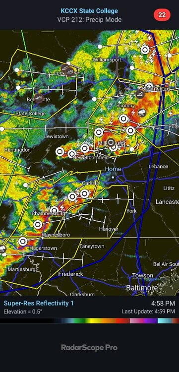
-
evere Weather Statement National Weather Service Baltimore MD/Washington DC 456 PM EDT Sat Jun 6 2026 MDC021-043-VAC069-WVC003-027-037-065-062115- /O.CON.KLWX.SV.W.0074.000000T0000Z-260606T2115Z/ Washington MD-Frederick MD-Frederick VA-Jefferson WV-Morgan WV- Berkeley WV-Hampshire WV- 456 PM EDT Sat Jun 6 2026 ...A SEVERE THUNDERSTORM WARNING REMAINS IN EFFECT UNTIL 515 PM EDT FOR WASHINGTON AND NORTHWESTERN FREDERICK COUNTIES IN NORTH CENTRAL MARYLAND...NORTH CENTRAL FREDERICK COUNTY IN NORTHWESTERN VIRGINIA... CENTRAL JEFFERSON...CENTRAL MORGAN...BERKELEY COUNTIES IN THE PANHANDLE OF WEST VIRGINIA AND NORTHEASTERN HAMPSHIRE COUNTIES IN EASTERN WEST VIRGINIA... At 455 PM EDT, severe thunderstorms were located along a line extending from near Greencastle to near Martinsburg to near Greenwood, moving east at 50 mph. HAZARD...70 mph wind gusts. SOURCE...Radar indicated. IMPACT...Damaging winds will cause some trees and large branches to fall. This could injure those outdoors, as well as damage homes and vehicles. Roadways may become blocked by downed trees. Localized power outages are possible. Unsecured light objects may become projectiles. Locations impacted include... Hagerstown, Martinsburg, Thurmont, Charles Town, Emmitsburg, Shepherdstown, Municipal Stadium, Greenwood, Robinwood, Fountainhead-Orchard Hills, Ranson, Boonsboro, Smithsburg, Inwood, Paramount-Long Meadow, Wilson-Conococheague, Williamsport, Mount Aetna, Mount Lena, and San Mar. PRECAUTIONARY/PREPAREDNESS ACTIONS... For your protection move to an interior room on the lowest floor of a building. && LAT...LON 3956 7737 3928 7779 3940 7843 3972 7812 3972 7728 TIME...MOT...LOC 2055Z 277DEG 45KT 3975 7779 3953 7798 3938 7822 THUNDERSTORM DAMAGE THREAT...CONSIDERABLE HAIL THREAT...RADAR INDICATED MAX HAIL SIZE...<.75 IN WIND THREAT...RADAR INDICATED MAX WIND GUST...70 MPH
-
Numerous reports of tree damage and trees downed in W MD
-

Central PA Summer 2026 Discussion/Obs Thread
Storm Clouds replied to Voyager's topic in Upstate New York/Pennsylvania
That line looks like it means business. This also is much ahead of schedule. I thought this was going to be a sunset event or later for lower Susquehanna Valley? -
Watch just issued for entire NYC metro area
-
Danbury looks like a good spot. Storms over western PA in this environment are consolidating, and expectation is that they could arrive a little ahead of HRRR forecast, reaching the lower Hudson Valley and NE NJ between 6-8 PM, then continuing E across NYC, Long Island and S CT through the evening. SPC forecasts a slight risk of severe tstms for most of the area, with a 30% damaging wind threat from about NYC north/west.
- Today
-

-
Yeah, we somehow managed not to hit 90 Thursday Friday or today in Greenfield due to cloud contamination.
-
73.0° for the high even with a little late afternoon sun Don’t need severe. Let’s get some nice safe rain in here.
-
Junorch obs and discussion 2026
Damage In Tolland replied to Damage In Tolland's topic in New England
Do you like the derecho across the region tonight? -
Ever notice watches often stop in Berkshire and Litchfield Counties? I wonder why... WFO CWA boundary perhaps?
-
Fish fry at the crib? What time?