All Activity
- Past hour
-
Amazing how different the UP is compared to the lower peninsula.
-
.03 yesterday, 0.33 overnight.
-
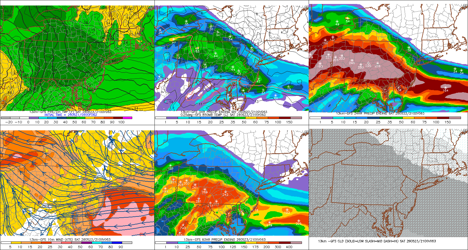
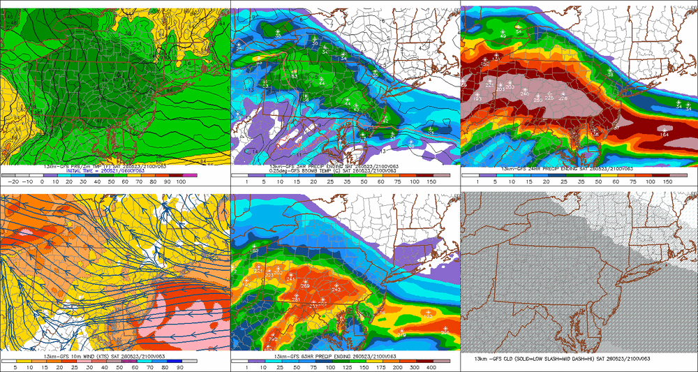
Jackpot zone so far from southern MoCo through HoCo. Around 1” for me. Couple thunder claps last night around 10-11pm were LOUD house shakers. Let’s keep it rolling today!
-
We have a dry-line-like phenomenon that is part of our spring/summer climo in New England that isn't really very well recognized. I've noticed too many times then can be counted since moving to this region of the country ...decades ago, that when it is hot and humid and a corrective cool front is approaching, we gap dry air out ahead. The synoptic mechanism for this may not be too terribly different than what happens in W Tx... in principle. We have higher elevations W, check. Wind tendency to back E of said higher elevations. Heating E tends to trough the structure of flow subtly, which is W d-slope component. That dries the air mass immediately to the W of the psuedo trough axis. The result is manufactures a dry line along the trough's axis... The real front is still back up stream mid NY/PA. Not exactly the same but I see similarities there. The main difference is that whence the d-line forms here, it races E. That's why we get that deep blue sky with dry cough sear heat still 88 to 91 degrees N of the Pike like we did yesterday so often in that set up. You see anvil heads on the S horizon.
-
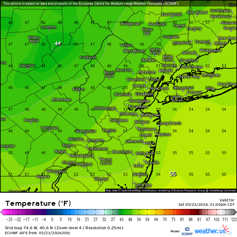
The big temperature swings pattern continues. We saw something like this with the record warmth and hard freeze earlier this spring. Now it looks like afternoon temperatures will be the upper 40s to low 50s on Saturday following the upper 90s a few days ago.

-
.03” overnight. With a 90% chance of a trace of precipitation throughout the day. AKA English spittle all day. Heading down to Wolf Trap for a concert tonight. No horrible heat but the drive down with rain will for sure be interesting. Opting to take 15.
-
Thank you! Here’s to another year of woo storms and woo sleet and woo drought with you and all the other weenies
-
Next week looks like great weather. Mid to upper 70’s and dry.
-
My inner city street and back yard at the height of the storm. As always …. IMG_1322.mov IMG_1323.mov IMG_1324.mov
-

Central PA Spring 2026 Discussion/Obs Thread
mahantango#1 replied to Voyager's topic in Upstate New York/Pennsylvania
-
Just drizzle at the moment but that's a nice slug off to my west
-
May need the heat here on Sunday. I’ll take the rain. Goofus is basically a goose egg after this weekend.
-

2026 Spring/Summer Mountain Thread
Maggie Valley Steve replied to Buckethead's topic in Southeastern States
Already raining at the house this morning. -
Central PA Spring 2026 Discussion/Obs Thread
mahantango#1 replied to Voyager's topic in Upstate New York/Pennsylvania
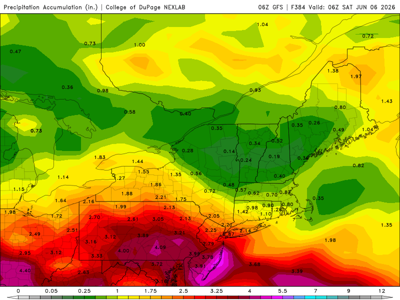
Eric Finkenbinder proeSdstongm2tufgtg04g4tc8lggulc10l73l9mi34hh9t03c1ht5h119u4 · Far western Juniata county received over 3 inches of rain Wednesday afternoon! -

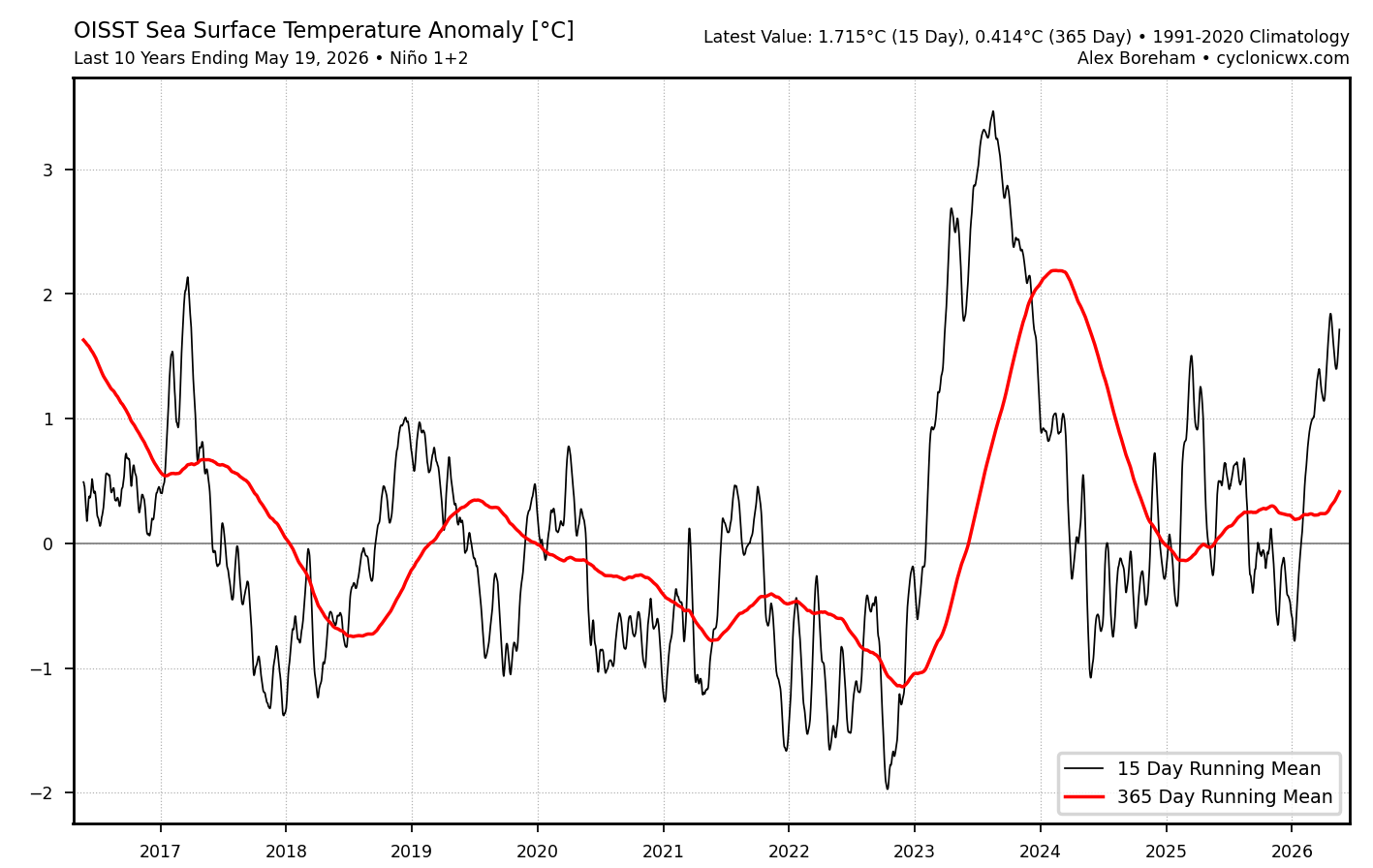
2026-2027 Strong/Super El Nino
bluewave replied to Stormchaserchuck1's topic in Weather Forecasting and Discussion
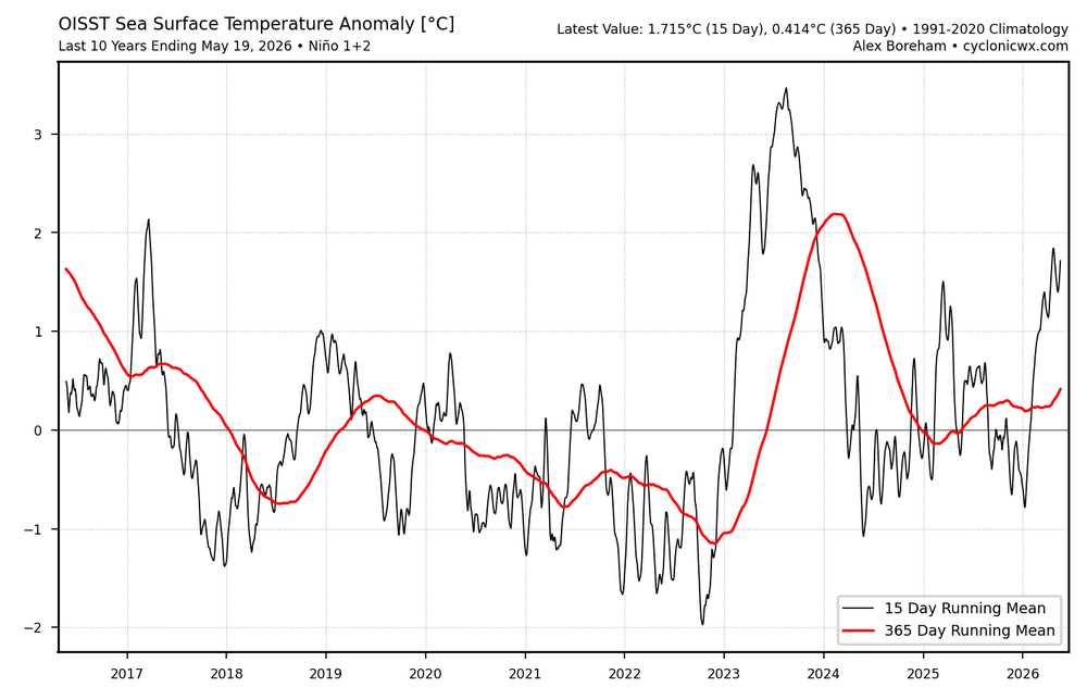
It could be related to the EPAC near Nino 1+2 not fully cooling off following the +2.1 ONI event back in 2023-2024. All the ONI events over plus +2.0 since the early 1970s had a stronger return to La Niña conditions in the following years even to Nino 1+2. We can also notice the La Ninas following super El Niños weakening over time. The recent La Niña was one of the weakest on record following such a strong El Niño. Plus back in November of 2024 we had a Nino +1.2 warming leading to the Nino-like December 2024 pattern and the 2nd warmest CONUS December with the record +PNA for a La Niña December. Many people commented how it looked like a El Niño December. The Aleutian Low was actually pretty strong for a change. Very unusual Nino +1.2 warming in November 2024 and Nino-like December 2024 So it appears that the 2023-2024 and 2026-2027 events are almost running together like the 2023-2024 event never fully ended. Something like this hasn’t happened before in or modern climate era. So it will be interesting to see what happens following this event in 2027-2028. La Ninas getting weaker following +2.0 ONI El Niño events 1972-1973 ONI +2.1…..1973-1974 ONI -2.0 1982-1983 ONI..+2.2…1984-1985 ONI..-1.1 1997-1998 ONI….-2.4…1999-2000 ONI -1.7 2015-2016..ONI….+2.8…2017-2018 ONI…-0.9 2023-2024 ONI +2.1….2025-2026 ONI…-0.5 Nino +1.2 never fully cooled off between El Niño events which is a first in the modern climate era.
-

2026-2027 Strong/Super El Nino
40/70 Benchmark replied to Stormchaserchuck1's topic in Weather Forecasting and Discussion
Correct, but it had a -WPO, which is why it was actually a decent season. -

Central PA Spring 2026 Discussion/Obs Thread
Superstorm replied to Voyager's topic in Upstate New York/Pennsylvania
0.45” in rain bucket since yesterday. . -
Monday could be ok aftn. To me weekend blows.
-
Good rain yesterday evening 1.01”
-
Saturday showers hold off till dark in this area. Monday the sun comes out for all . Sunday is a bad day
-
.47 in my section of NW DC.
-

Central PA Spring 2026 Discussion/Obs Thread
Mount Joy Snowman replied to Voyager's topic in Upstate New York/Pennsylvania
Low of 60 and .34” of rain. Nice string of cool showery days ahead. -
We got on the board with .11 last night.
- Today
-
You can do it put your into it
-
That’s a pain in the ass, hopefully no damage, that’s a bigger pain in the ass.