All Activity
- Past hour
-
ineedweenies is getting that tingly feeling in his nether regions...
-
Right now is pretty close to flawless. If we were to break top 10ing down to the hour, this is a top 1 or 2 hour out of the year right now as we type and read.
-
beautiful and ez on the wallet but pure zzzzzzs

-
This weekend is likely more just showers versus a widespread steadier rain. There will probably be a narrow axis, however, where there is some steadier/heavier rain but that will likely be confined to somewhere in NNE.
-
No one wants an hour less of sunlight in the evenings in the summer with that scenario. Sunset in NYC would be at 7:30 vs 8:30pm.
-
Morning discussion from GYX noted 0°C or colder 850s and the possibility of some graupel and/or snow at elevations this weekend. Sunny 70s here today.
-
Driest spring of all time and the second we hit Memorial Day weekend it's non-stop waves of showers and thunderstorms. We've been under a Flood Watch in Atlanta for close to 48 hours now with more to come. Washed out of both days of our first tournament weekend of the summer and looks like it'll be a repeat next weekend. At least there should be some decent improvement on the drought monitor when it comes out.
-
Doesn't seem all that wet next weekend per the P&C...
-
I remember January 1974..I was in my classroom taking a final at it was pitch black at 830am..Is that more sunshine?. I think it's hard for people to get up for work and school in darkness. And the kids at the bus stops?..is it safe in the dark?..Now going All Standard time might work if you don't want to change the clock at all.
-
.26 with the morning surprise...heading out west today glad i won't return to dead grass plants.
-

Central PA Spring 2026 Discussion/Obs Thread
Mount Joy Snowman replied to Voyager's topic in Upstate New York/Pennsylvania
I believe it. It was such a slow light soaking long duration event that there was virtually no runoff, ground just ate it all up. Grass and shrubbery have to be loving it. I know people didn't love it because of its timing over Memorial Day weekend, but it really was a pretty unique late May weather stretch. It didn't really bother me at all. -
77
-

2026 Spring/Summer Mountain Thread
Maggie Valley Steve replied to Buckethead's topic in Southeastern States
Just had a round of torrential rain that lasted about half hour here in the Valley. -
summer for next 2 days..then April/early may returns for a week? Been a brutal stretch for the torch crew
- Today
-
If my math is correct, I’ve cut the drought in half at my location over this past week.
-
71° now off a min of 48.3°
-
Big time totals.
-

Central PA Spring 2026 Discussion/Obs Thread
Itstrainingtime replied to Voyager's topic in Upstate New York/Pennsylvania
All of the wet weather and the Susky is barely flinching in response. Total rise in Marietta looks to be about a foot, and some 10' below flood stage. One of the testaments of how dry it's been over the long haul. -
Per Cocorahs reports, Henderson and surrounding counties have been hit with very heavy rains in the aggregate during the 96 hours ending at 7AM today! 5/22-3: 5/23-4: 5/24-5: 5/25-6:
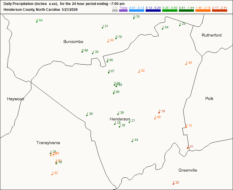
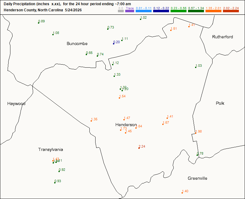
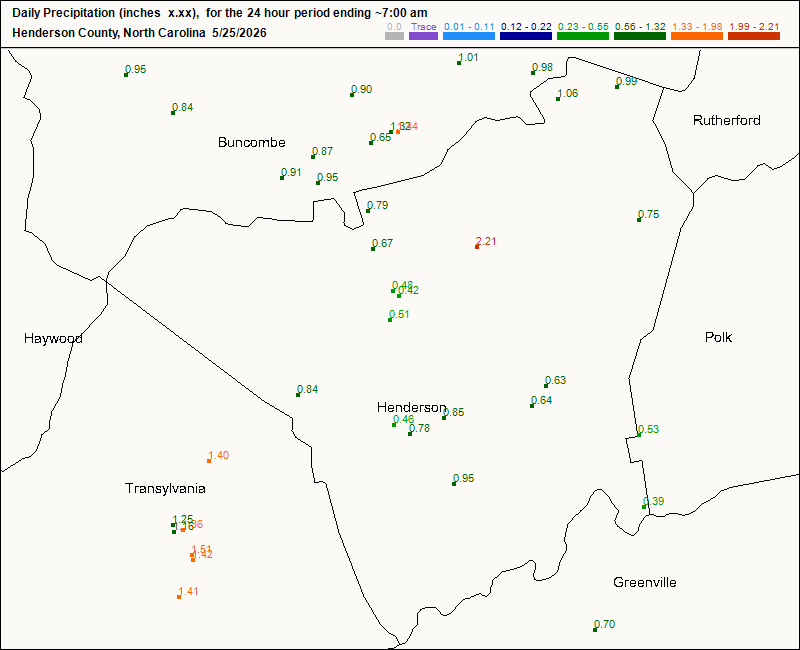
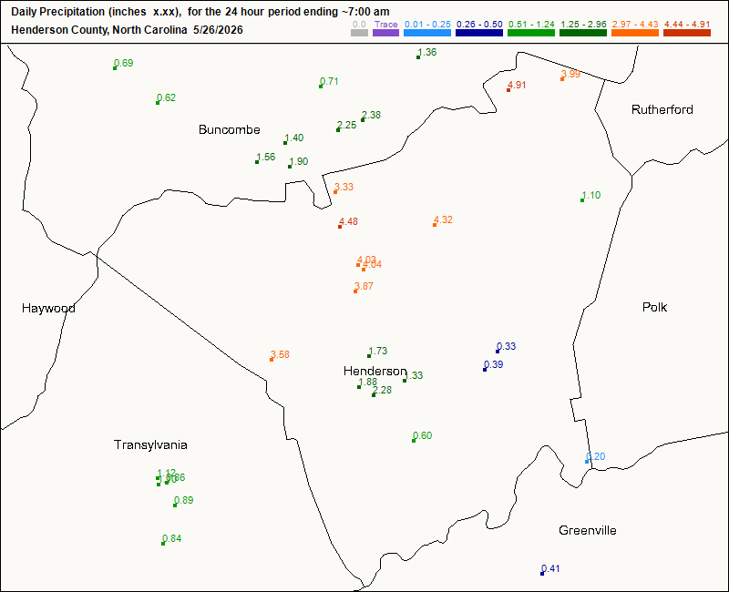
-
I am hoping the weekend rain mostly stays south at this point
-

2026-2027 Strong/Super El Nino
bluewave replied to Stormchaserchuck1's topic in Weather Forecasting and Discussion
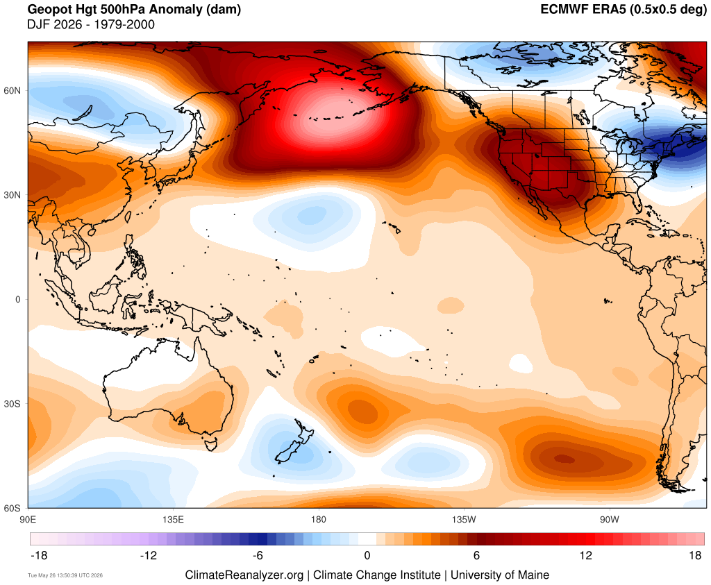
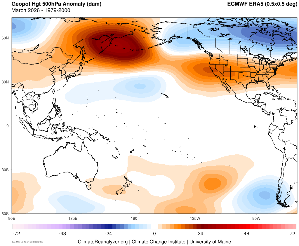
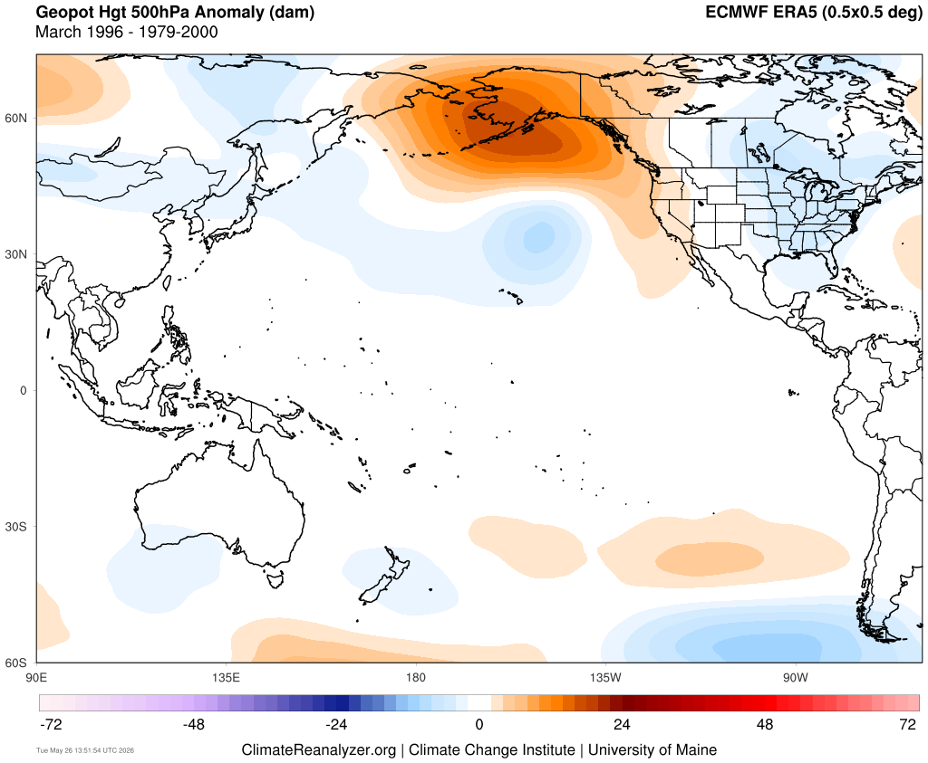
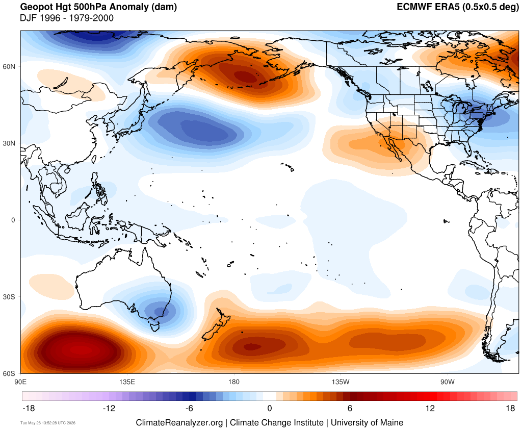
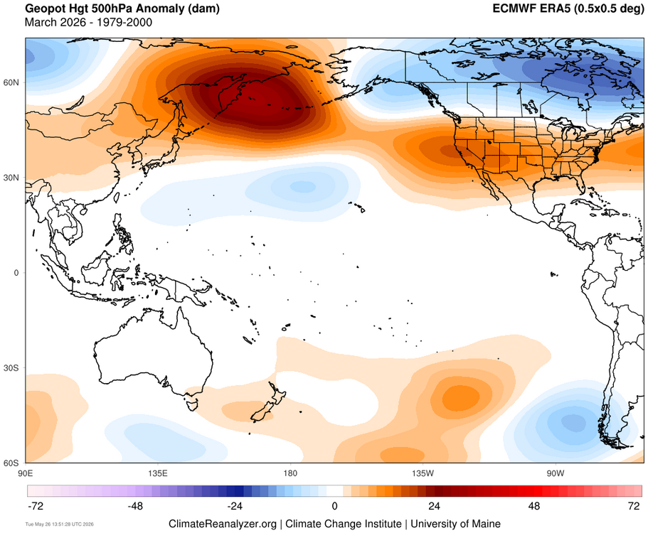
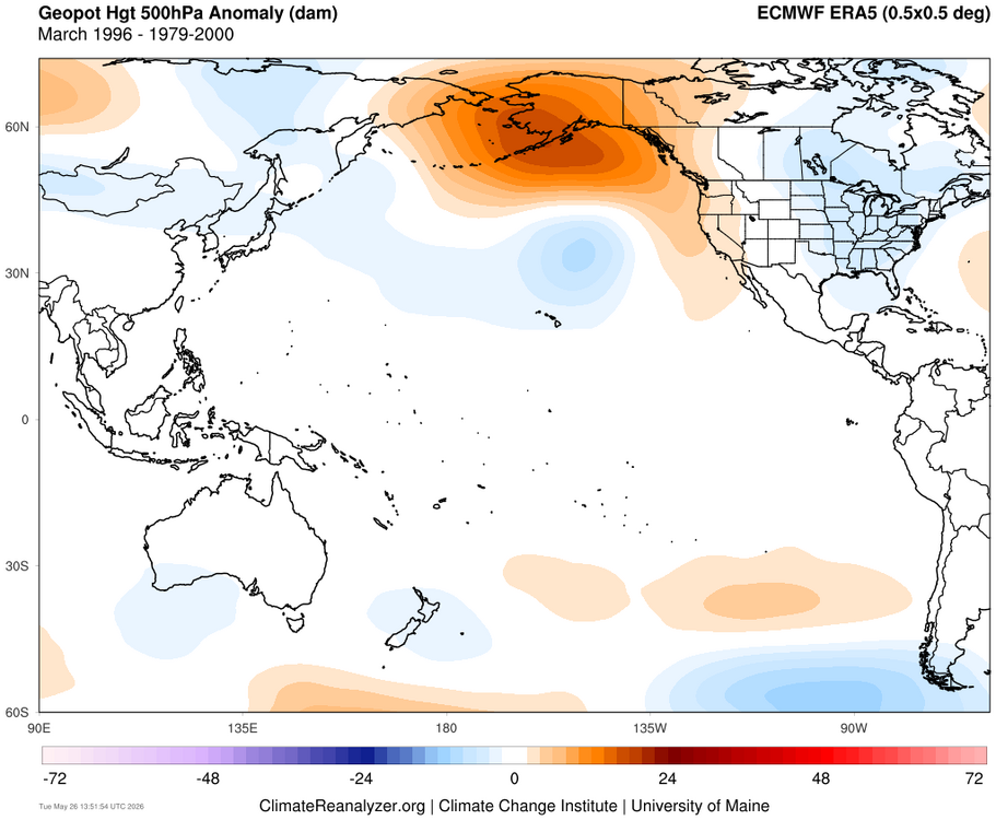
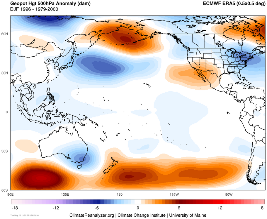
Yeah, the PDO was able to be positive during the 1995-1996 weak La Niña winter. This weak La Niña winter had the ridges and troughs in the same general locations. But notice how the ridges this winter were so much stronger leading to the much warmer CONUS and less snowy outcome than 1995-1996. We can see the ridge extension to the east of a Japan during DJF preventing the PDO from going positive. Plus the more volatile NAO these days didn’t allow the -NAO to persist into the spring like we had back in 1995-1996. So March turned out to be a reversion to the warmer and less snowy 2020s mean.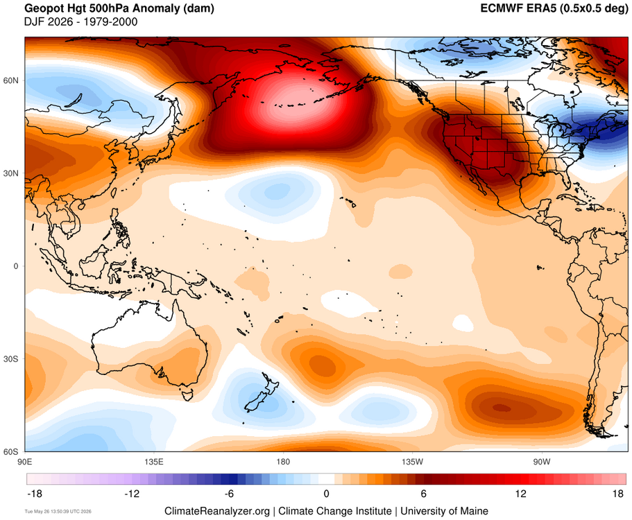
-

2026-2027 Strong/Super El Nino
40/70 Benchmark replied to Stormchaserchuck1's topic in Weather Forecasting and Discussion
No it wasn't. It was clear as day that January would be +PNA at several months lead time if you knew what to look for. -
Watch the NE Gulf and vicinity for a possible TS next week per some model runs.
-

E PA/NJ/DE Spring 2026 Obs/Discussion
The Iceman replied to PhiEaglesfan712's topic in Philadelphia Region
first half of june looks dry but comfortable at least -
May 26 1929: A tornado rakes Freeborn County and causes 10,000 dollars of damage to farms. For Tuesday, May 26, 2026 1771 - A famous Virginia flood occurred as heavy rains in the mountains brought all rivers in the state to record high levels. (Sandra and TI Richard Sanders - 1987) 1917 - A tornado touched down near Louisiana MO about noon and remained on the ground for a distance of 293 miles, finally lifting seven hours and twenty minutes later in eastern Jennings County, IN. The twister cut a swath of destruction two and a half miles wide through Mattoon, IL. There were 101 persons killed in the tornado, including 53 at Mattoon, and 38 at Charleston IL. Damage from the storm totaled 2.5 million dollars. (David Ludlum) 1984 - Thunderstorms during the late evening and early morning hours produced 6 to 13 inches of rain at Tulsa OK in six hours (8.63 inches at the airport). Flooding claimed fourteen lives and caused 90 million dollars property damage. 4600 cars, 743 houses, and 387 apartments were destroyed or severely damage in the flood. (Storm Data) (The Weather Channel) 1987 - Thunderstorms in southwest Iowa spawned five tornadoes and produced up to ten inches of rain. Seven inches of rain at Red Oak forced evacuation of nearly 100 persons from the town. Record flooding took place in southwest Iowa the last twelve days of May as up to 17 inches of rain drenched the area. Total damage to crops and property was estimated at 16 million dollars. (The National Weather Summary) (Storm Data) 1988 - There was "frost on the roses" in the Upper Ohio Valley and the Central Appalachian Mountain Region. Thirteen cities reported record low temperatures for the date, including Youngstown OH with a reading of 30 degrees. Evening thunderstorms in North Dakota produced wind gusts to 75 mph at Jamestown. (Storm Data) (The National Weather Summary) 1989 - Thunderstorms in produced large hail in eastern Oklahoma during the pre-dawn hours, and again during the evening and night. Hail two inches in diameter was reported near Prague, and thunderstorm winds gusted to 70 mph near Kenefic. (Storm Data) (The National Weather Summary) 1990 - Thunderstorms produced severe weather from eastern Colorado to western Arkansas and northeastern Texas. Severe thunderstorms spawned three tornadoes, and there were eighty-eight reports of large hail or damaging winds. Evening thunderstorms over central Oklahoma spawned strong tornadoes east of Hinton and east of Binger, produced hail three inches in diameter at Minco, and produced wind gusts to 85 mph at Blanchard. (Storm Data) (The National Weather Summary)