All Activity
- Past hour
-
Shot up to 30 here from a low of 14, but has leveled off. I'm thinking I'm going to be on the warmer side of 32 for most of this event, but we'll see.
-
I didn’t say it was bad everyday lol. You guys need to re-read what I wrote. I said the model has various impulses moving through every other day on average? Which was objectively true
-
I didn’t say everyday lol
-

Central PA Spring 2026 Discussion/Obs Thread
Mount Joy Snowman replied to Voyager's topic in Upstate New York/Pennsylvania
Oh wow good to know. I saw it on the Lancaster incidents map and then checked google traffic where it said it would reopen at 12:30 but I guess that was just a conservative estimate and they got it cleared much quicker. -
Sucks for them…poor kids. What kid wants to be doing school work as a blizzard is Raging outside.
-
yeah, has the feeling of a lot of 33 and rain around here.....if this was early February and not March sure, my solar panels are producing pretty well currently despite clouds and light snow falling
-
Once I get a taste of near 80 next week, it’s over.
-
I think it’s more about sidewalks and lots and Drieways a lot of slip risk with the kids when they get dismissed “IF” the cold holds.. still not sold as I’m up to 31 here
-

Outta gas and Outta Time: Early March Winter Storm finale
Chris78 replied to Ji's topic in Mid Atlantic
Desert -
We still got 3 more weeks to get a late comeback Let's do it.
- 1 reply
-
- 2
-

-

-
And that was my point…what is he looking at? The downer syndrome that he has, must distort his ability to see what is actually going on. Ya hate to see it.
-
we GFS ice storm
-
Classic….perhaps. But probably more on the extreme end ..no?
-

Outta gas and Outta Time: Early March Winter Storm finale
EastCoast NPZ replied to Ji's topic in Mid Atlantic
This was 0 when I woke up. Radar showed a bit move through around 8:30 this morning. There was a specklung of ice on the windshield this morning. But it was mist at best overnight.
-
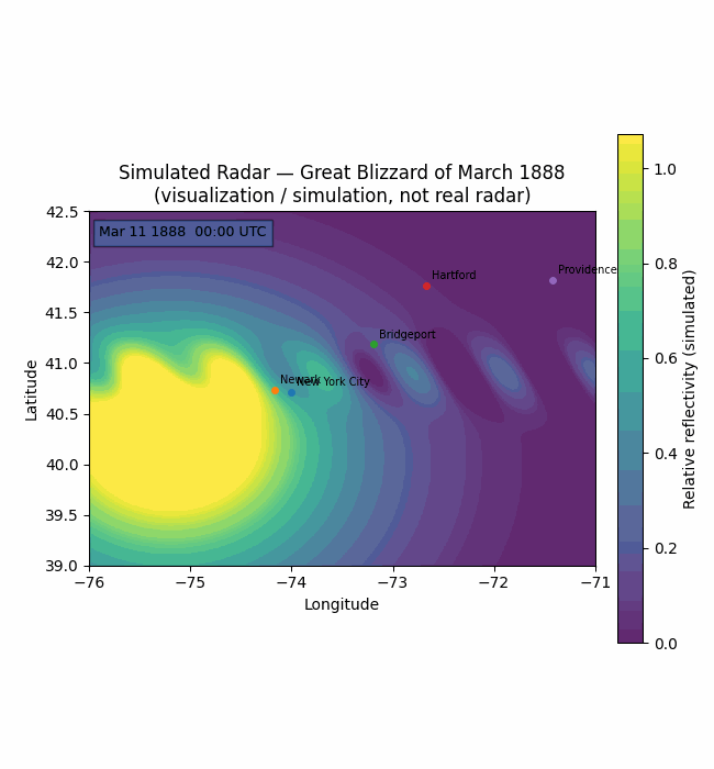
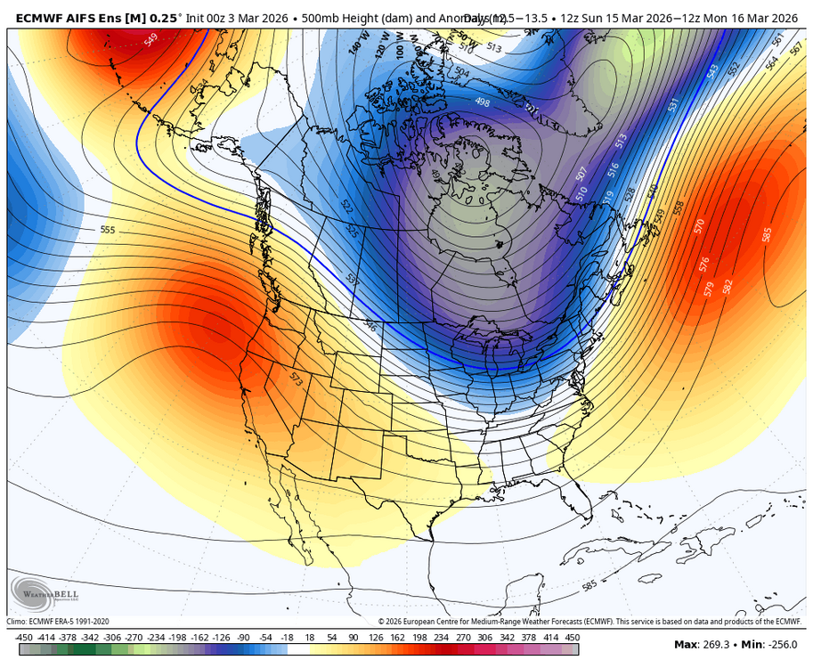
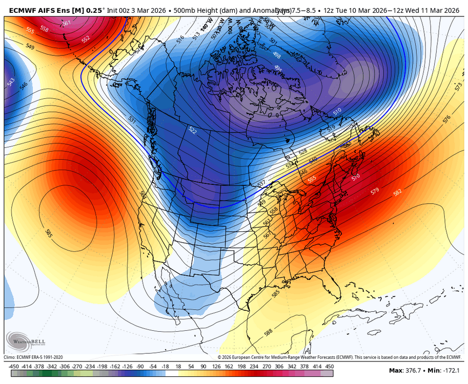
This needs work, but I gave it a half-hearted try: Simulated Radar Loop: March 11–14, 1888 March 11 (Evening): A low-pressure system moves up the Atlantic coast, initially appearing as a broad area of light-to-moderate rain across the Mid-Atlantic. March 12 (Midnight): As the storm reaches the New Jersey coast, it undergoes explosive cyclogenesis. On radar, you would see a sharp "rain-to-snow" line as cold Canadian air rushes in, turning precipitation into heavy, blinding snow over NYC. March 12 (Midday): The storm's "eye" or center (reaching a peak intensity of 978 hPa) sits just offshore. A massive, stationary band of intense snowfall (reflectivity values of 40+ dBZ) stalls over New York and western New England. March 13: Instead of moving out to sea, the cyclone loops counterclockwise near the southern New England coast. On a loop, the heavy snow bands would appear to rotate and pinwheel over the same regions for over 24 hours, dumping up to 22 inches in NYC and nearly 60 inches in parts of New Jersey and upstate New York. March 14: The system finally weakens and drifts east into the Atlantic, with the simulated radar showing the heavy bands breaking into scattered snow showers.
-
if we have an east based super nino heading into fall...then yea best to just assume the winter is going to be a dead ratter. I know you were joking but some do just automatically assume Nino=Snow. Which is funny because I remember after we had 3 dead ratter nino's in a row, 1992, 1995, and 1998, the prevailing thought before 2003 was Nino=warm snowless winter lol. Then we had a run of extremely snowy nino's and it flipped the other way. The truth is somewhere in between and that it depends on the details.
-
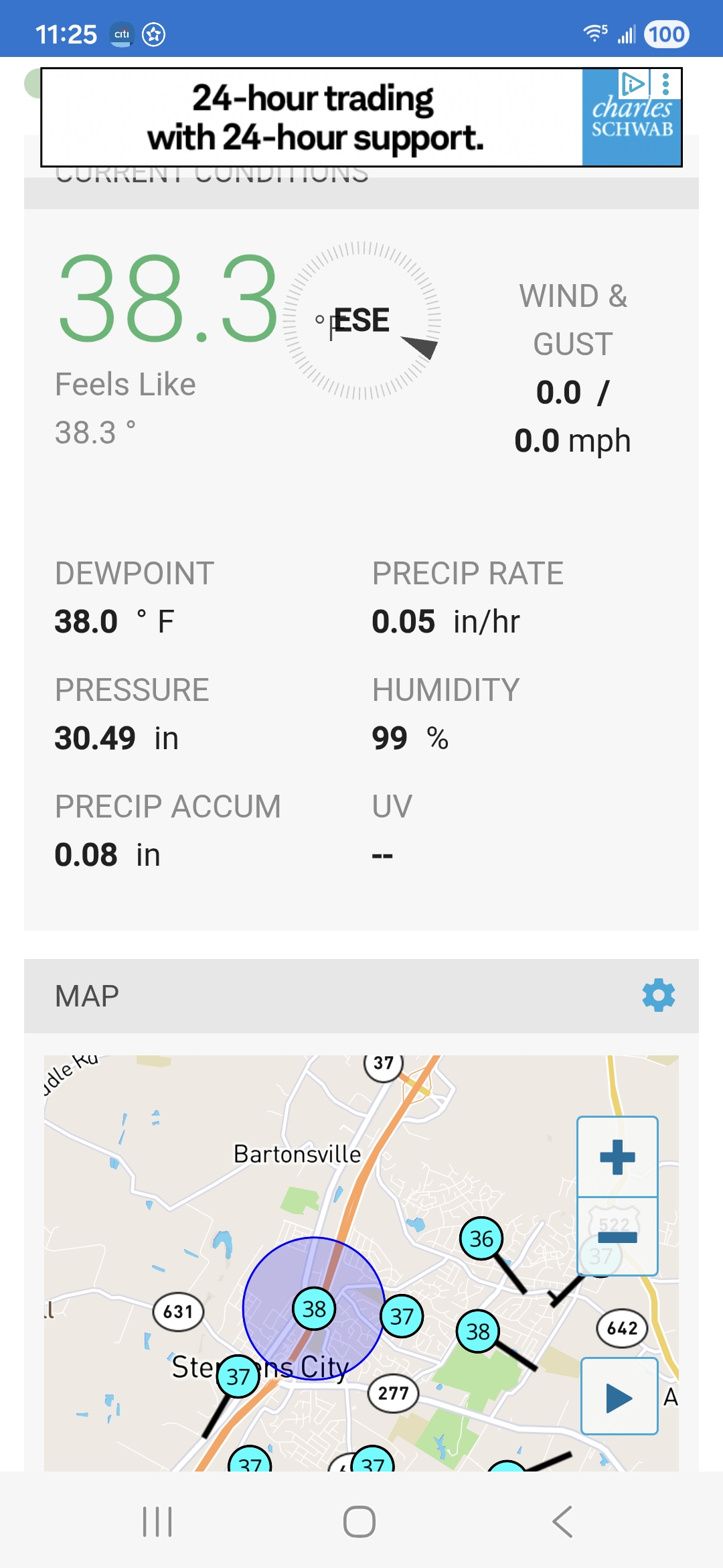
you would need heavy rates in march especially mid day to cause road issues with temps 30-32
-
This weather sucks. Hope this isn’t gonna be one of those years where it takes until May to get 3 days in a row of nice weather.
-
29.4/12 with BKN cirrus now Nice day Snow at night Nice day is how you draw it up
-

Outta gas and Outta Time: Early March Winter Storm finale
Maestrobjwa replied to Ji's topic in Mid Atlantic
I see the freezing line held longer than expected even here in the city last night, lol -
GFS and GGEM not too aggressive with the BDCF late this week. NAM does look aggressive, but at the end of range obviously.
-
classic spring swing here
-
Great Dakotas blizzard of 1966 Click on the highlighted link, in this link, for cropped black and white scans to see some images. www.accuweather.com/en/winter-weather/1966-blizzard-provided-north-dakotas-most-famous-photo/1868770
-
We snow. 24.8
-
Let’s give this last opportunity a go! I don’t have any chips left though. Anyone got some I can borrow? Will trade you for beers.