All Activity
- Past hour
-
-
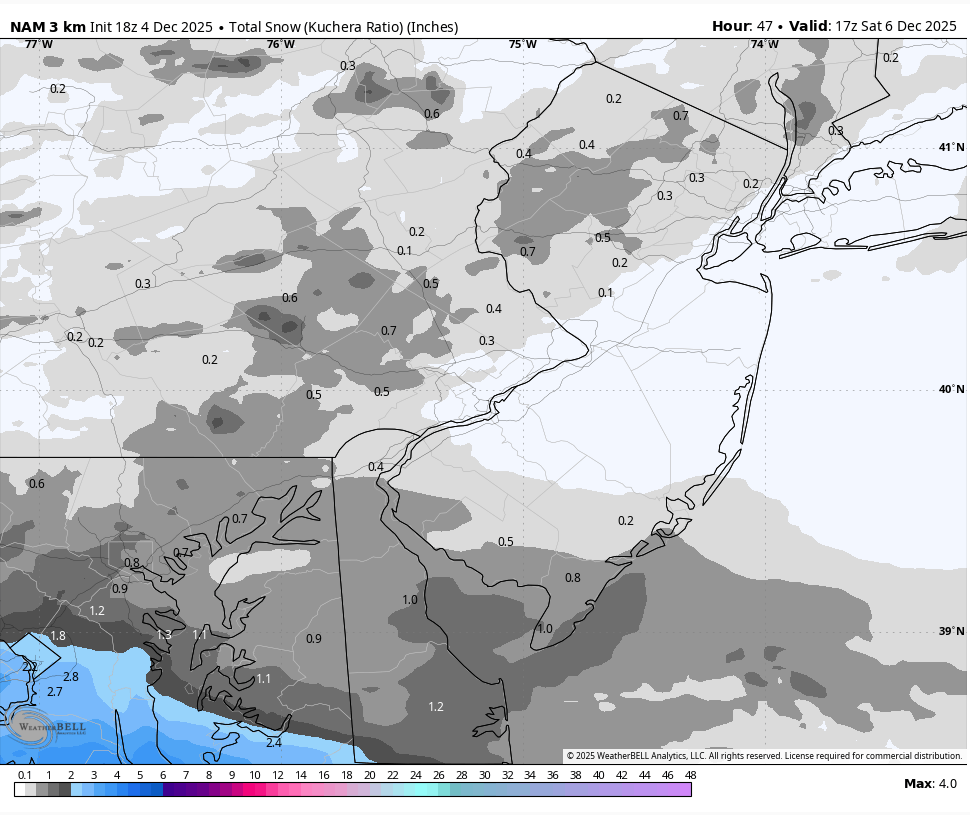
The RGEM has a little snow early Saturday. It's not much and it will probably shift east or be flurries if it's even real, but it's something...
-
.thumb.png.4150b06c63a21f61052e47a612bf1818.png)
December 2025 regional war/obs/disco thread
HIPPYVALLEY replied to Torch Tiger's topic in New England
Decent snow shower here coated the cars. -
1.6" at DCA would be the snowiest December event for the airport in 16 years. Guidance says to take the under but certainly not off the table.
-
45.3 and it feels cold. .
-

December 2025 regional war/obs/disco thread
SouthCoastMA replied to Torch Tiger's topic in New England
On that point, the last 5 years have been so bad that we might actually do well relative to that span over the next 5, despite the overall decline over the long term. We shall see -
I’m incautiously confident that DC will get 1-3”, and somewhere within a 25 mile radius of DC will get 4”.
-
Here we go, good luck everyone. JKL radar appears to be down on radarscope. 33 degrees & 28 Dew point

-
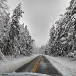
we've had a handful of whiteout squalls this afternoon. got on 87 earlier and about 10 mins in couldnt see 15 feet in front of me
-
Being a late-nighter anyway, I'm sure I'll be checking, but if this were a poker hand, I'd be wise to fold.
-

2025-2026 Fall/Winter Mountain Thread
Buckethead replied to Buckethead's topic in Southeastern States
33/3 in Wolf. That's some pretty dry air . Sent from my Pixel 10 Pro using Tapatalk -

December 2025 Short/Medium Range Forecast Thread
tnweathernut replied to John1122's topic in Tennessee Valley
40 here in Erwin. Fully expect the warm nose to keep Tri mostly rain, but willing to accept being wrong. Think SW VA and parts of eastern KY do well with this little system. -
Nice map! Virginia living right: UVA in ACC championship and chance for playoffs, VT has shiny new coach, and SNOW
-
I've got the snowboard ready. I'm expecting 2 to 3 inches here along the NC/VA border in Rockingham County.
-

Central PA Banter (Banter Less?) Thread
WE GOT HIM replied to Itstrainingtime's topic in Upstate New York/Pennsylvania
We are playing Geo guesser tonight if you want to play -

December 2025 regional war/obs/disco thread
weathafella replied to Torch Tiger's topic in New England
Riding through some heavy squall snow about 20 miles east of Syracuse. West of Rochester to Syracuse was dicey. -

Richmond Metro/Hampton Roads Area Discussion
mikeeng92 replied to RIC Airport's topic in Mid Atlantic
Radar looks nice in Tennessee -
(002).thumb.png.6e3d9d46bca5fe41aab7a74871dd8af8.png)
E PA/NJ/DE Winter 2025-26 Obs/Discussion
ChescoWx replied to LVblizzard's topic in Philadelphia Region
As we always try and present any and all models that produce any measurable snow.....we do have the 18z NAM with a move north of accumulating though minor snow tomorrow PM.
-

Central PA Fall Discussions and Obs
mahantango#1 replied to ChescoWx's topic in Upstate New York/Pennsylvania
Took notice I got down to 18 last night, coldest so far this season. I wonder how low I'll drop tonight? -
Ha. That's right. Temporarily forgot about that one. Five times in the 00s. Wild indeed. Looking forward to adding to this tally tomorrow.
-

December 2025 Short/Medium Range Forecast Thread
Carvers Gap replied to John1122's topic in Tennessee Valley
I have to think the northern Plateau, SE KY, SW VA, and 1500'+ in NE TN....gonna have a decent little event from this. The cloud cover today has prevented warmer temps from rolling in.. -
35 degrees up here on Beech at 4pm. I love these chilly overcast winter days.
-
Should mention "hot and heavy" is still in the context of this storm's version of it. Though it will definitely be pretty as it falls.
-
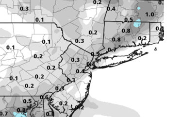
Just about nowcasting time, but IMO, 18z ICON looks better in that its a bit more smoothed out with its 1 inch marker delineation on the 18z run compared to the 12z run
-
Central PA Banter (Banter Less?) Thread
WE GOT HIM replied to Itstrainingtime's topic in Upstate New York/Pennsylvania
talk about weather and sports?