All Activity
- Past hour
-
In my sig
-

Saturday night/Sunday 12/13-12/14 Jawn
kickingupastorm replied to Ralph Wiggum's topic in Philadelphia Region
Can you please post the map? -
It’s been reliably the most robust of the guidance for this upcoming event. Really living up to its predecessor.
-

12/14: Sunday funday? Will the south win again?
Maestrobjwa replied to TSSN+'s topic in Mid Atlantic
Yeah it has been a historical shaft to say the least! Would be so good to get this one -
I hope the broader Baltimore crew hits on this one. 4 plus inches. They're due
-
Hasn't that area been constantly shafted the last several years even though we had good snows the last couple of winters? I'm rooting hard for you folks up there!
-

December 14th - Snow showers or Plowable snow?
weatherwiz replied to Sey-Mour Snow's topic in New England
Figured why not. Anyways, unless you're close to the llvl fronto, I don't see much in the way to assist with QPF blossoming moving poleward from the developing llvl fronto band. As was stated, there could be some dry air concerns on the northern fringes of the precipitation shield and with some strengthening evidence for a more pronounced llvl fronto band, I do think there could be some room for subsidence skunking. I could see 3-5" across Long Island and probably some amounts in that range too possibly along the south coast. It's really the south coast at this point which has room for anything exceeding 2". Where stronger lift can occur will benefit from the ratios. But overall I see a pretty bland looking precipitation area outside of right where the llvl fronto is
-

Minor snow possible sunday 12/14/25
coastalplainsnowman replied to WeatherGeek2025's topic in New York City Metro
Orzo it seems. -

December 11th-14th Double Banger Clippers
Jackstraw replied to Jackstraw's topic in Lakes/Ohio Valley
I think a lot of us that have been living in a snow desert were salivating at anything over an inch whenever we could get it lol. A lot of us gladly traded a white Tday weekend for a white Xmas because of that. And we don't really know if this pattern is going to re-load or we just torch or freeze/suppress into frozen tundra. I know its been over 5 years since I've hit my yearly snow total. This 2nd one will at least give us a blanket for the freeze coming. I hate frozen tundra crap. Snow is the REASON for bitter cold. Without snow, to quote O'Brother Where Art Though, cold just ain't Bonafide Good luck tomorrow! -
Icon is worse - mainly due to it being warm at the sfc. That unfortunately seems to be the trend across guidance. Temps at onset aren’t cooling quick enough.
-

12/14: Sunday funday? Will the south win again?
NorthArlington101 replied to TSSN+'s topic in Mid Atlantic
-

December 2025 regional war/obs/disco thread
Ginx snewx replied to Torch Tiger's topic in New England
Amazing considering the West has been shut out. With no real torch in sight Mansfield could eclipse 68/69 if everything breaks right -
The LWX AFD effectively highlights the strong dynamics at work. It would not surprise me to see someone between Baltimore and Philly/S Jersey get half a foot of snow from this.
-

December 2025 regional war/obs/disco thread
powderfreak replied to Torch Tiger's topic in New England
4" more today. 19" measured since Wednesday AM. It skis like 30" though, ha. -

December 2025 Short/Medium Range Forecast Thread
Carvers Gap replied to John1122's topic in Tennessee Valley
Afternoon disco from MRX... 922 FXUS64 KMRX 121734 AFDMRX Area Forecast Discussion National Weather Service Morristown TN 1234 PM EST Fri Dec 12 2025 ...New DISCUSSION, AVIATION... .KEY MESSAGES... Updated at 1232 PM EST Fri Dec 12 2025 - Light snow accumulations possible mainly in the mountains Saturday night into Sunday. - Bitter cold will surge into the area for Sunday into Monday. - Warming trend begins Tuesday. && .DISCUSSION... Issued at 1232 PM EST Fri Dec 12 2025 Tonight into Saturday we will be under the influence of surface high pressure, and high temperatures will be near to slightly above normal for this time of year on Saturday. The brief warmup will quickly be forgotten as a strong cold front surges through our area Saturday night ushering in an arctic air mass for Sunday into Monday. The front will have little moisture to work with, but we will likely see some showers quickly changing over to snow showers and flurries Saturday night as the front moves through, with snow showers and flurries lingering into Sunday especially over the normally favored higher elevation areas as the northwest flow and cold advection continues. Right now, it appears any snow accumulations will be most likely over the higher elevations of the E TN mountains and SW VA as is typical in these scenarios. Current ensemble data suggests a very low chance (around 10-30%) of exceeding one inch of snow even in these favored areas, but think this is underdone at this point and as more hi-res guidance is incorporated these probabilities will likely increase. Even so, any snow accumulations are expected to be light. The bigger story for most folks will be the cold. High temperatures Sunday daytime temperatures will generally be near or below freezing even in valley areas, and the wind will make it feel even colder. Lows Sunday night will be in the single digits and teens, and while it currently appears winds will be on the decline during Sunday night which will suppress what could be even worse wind chills, still wind chill values in the single digits will be common in the valleys with below zero values for the higher mountains at times Sunday night into Monday morning. It is still unclear how much if any of the area will dip into cold weather advisory territory Sunday night into early Monday, but it looks close enough to warrant continued inclusion in the HWO for now. The center of surface high pressure will eventually shift to our east by Tuesday allowing for a gradual warmup to begin, and temperatures will likely be above normal by Thursday. Both Tuesday and Wednesday will be dry, but moisture will begin to increase later in the week. Models are still in poor agreement on exactly when the next chance for precipitation will arrive, but current ensemble data supports having chances for rain back in the forecast by Thursday. -

Minor snow possible sunday 12/14/25
SHELEG replied to WeatherGeek2025's topic in New York City Metro
Can we change the title of this thread To something like first plowable snow of the season for many? -

Winter 2025-26 Medium/Long Range Discussion
Chicago Storm replied to michsnowfreak's topic in Lakes/Ohio Valley
they will, cause right now they’re not enthused. -
December 2025 Short/Medium Range Forecast Thread
Carvers Gap replied to John1122's topic in Tennessee Valley
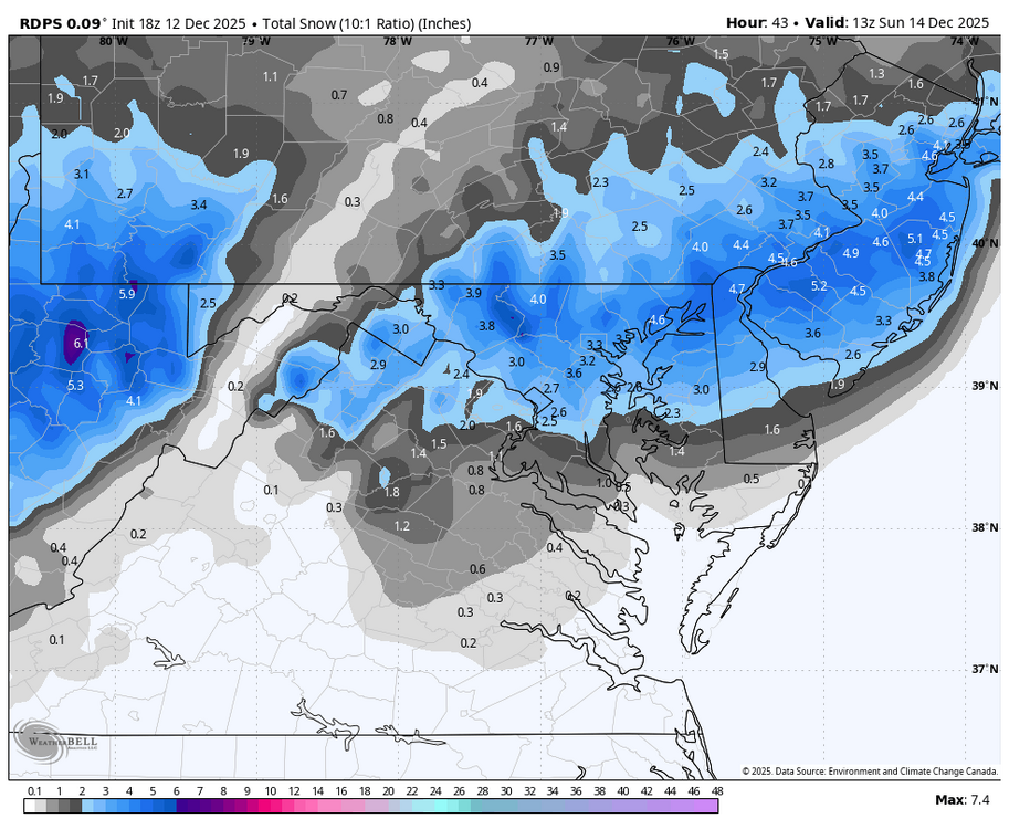
MRX graphic from social media. Feel free to post your local. -
It just gets started a little too late... just like most of our transfers
-

December 14th - Snow showers or Plowable snow?
ORH_wxman replied to Sey-Mour Snow's topic in New England
We’ll need slight nudges north almost every cycle from here on out to get solid advisory amounts more than 25 miles north of the south coast. Your area might not need quite as many nudges. -
December 2025 Short/Medium Range Forecast Thread
Carvers Gap replied to John1122's topic in Tennessee Valley
Yeah, it's just December 11th. Today's Euro Weeklies control flips the pattern back during the second week of January. IF we can pull that off, we have cold during the coldest weeks of the year. The warm solutions(and they are WARM) in ensembles are skewing the mean. For example, there might 14/25 members which are BN with temps, but the other 11 are raging warm. The mean would be well AN, but the median might be cold. I have always been taught that reality subtracts (as we get closer) the less likely members, and the more likely members are left. Do I think we see some warm-ups this winter? Absolutely, and models are honking at some chinook warmups Between Dec 20th and Jan 8th. That is a pretty normal time for a thaw. Nina winters really like to pull the trough back West for about 2/3 of winter, but the 1/3 we get can often be good. I don't see a thing which surprises me at this point. That said, I am not sweating AN temps when we have very cold temps on the way Sunday and Monday. I truly need about 7-10 days to warm-up. The cold in NE TN has been pretty relentless. -
As of this past August. I don't feel it.
-

December 14th - Snow showers or Plowable snow?
TauntonBlizzard2013 replied to Sey-Mour Snow's topic in New England
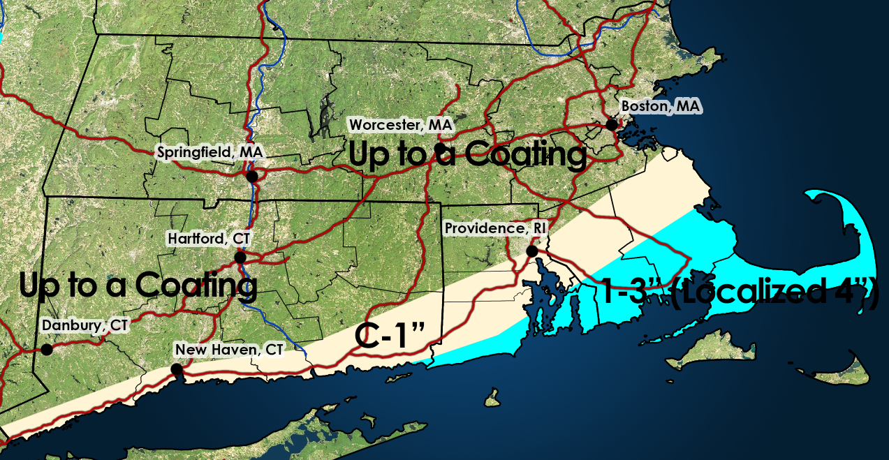
Too bad, there’s some stronger stuff just offshore on the RGEM, talking 50-75 miles to get a solid advisory event for many. But it def regressed here. 4-5” at 12z became 2-3” at 18z -
Appalachians, precipitation will struggle to make progress to the east of the Allegheny Front for several hours. As the wave amplifies and approaches from the west, most models show a jet steak developing downstream, with forcing for ascent increasing within the equatorward entrance of the jet streak. Most solutions show the jet entrance region lining up right along I-95. Ascent within the jet entrance region may cause precipitation to jump eastward and develop in-situ along the I-95 corridor, largely skipping locations between the Allegheny Front and Blue Ridge. Precipitation within the jet entrance region to the east of the Blue Ridge is expected to blossom during the mid-late evening hours, and then slowly drift southeastward through the remainder of the night. The precipitation may begin as a brief period of rain or mixed rain and snow, especially along and southeast of the I-95 corridor. This mix should be short-lived however, as much colder air rushes in behind an Arctic front that will move through over the course of the night. In terms of timing, some light precipitation could begin as early as the mid-late evening hours, but the bulk of the precipitation along the I-95 corridor is expected to occur between roughly 11 PM and 7 AM. The band that will develop will be a relatively narrow feature, and will feature moderate to heavy snow at times. Snowfall rates within the band could near or potentially briefly exceed one inch per hour at times late Saturday night. With a narrow feature producing heavy precipitation, snow totals will be heavily dependent on the ultimate placement of this band. This, combined with the potential for a bit of mixing with rain at onset makes for a challenging snowfall forecast. Probabilistically speaking, 12z guidance has focused in on the I-95 corridor from DC northeastward, and then eastward along US-50 toward the Chesapeake, with northeast Maryland southward toward Annapolis having the greatest probabilities for higher totals. As of this moment, a broad 1-4 inches from the vicinity of the I-95 corridor eastward appears like the most likely scenario, with embedded maxes of 4-7 inches possible where the band resides for the longest time period. Since there will be very sharp snowfall gradients on the edges of this band, and there`s still a bit of uncertainty with respect to where this band will be, we`ve decided to hold off on issuing headlines to the east of the Blue Ridge for the time being. Headlines will almost certainly be needed eventually, and we`ll continue to assess trends and refine the forecast through the remainder of the day. Snow will end from northwest to southeast a few hours either side of daybreak, with the back edge of the snow clearing southern Maryland by around mid-morning. Strong cold air advection is expected behind the Arctic front through the day Sunday, with 850 hPa temperatures crashing to around -15 to -20 C by peak heating. This will cause temperatures to drop through the 20s over the course of the day. Northwesterly wind gusts to around 35 mph will make it feel even colder, pushing wind chills into the single digits and teens. After the snow moves out, dry conditions are expected to the east of the mountains. Upslope snow showers will linger in the Alleghenies over the course of the day. Cold and windy conditions will continue through Sunday night, with cold weather headlines likely being needed for portions of the area. &&
-

December 14th - Snow showers or Plowable snow?
bristolri_wx replied to Sey-Mour Snow's topic in New England
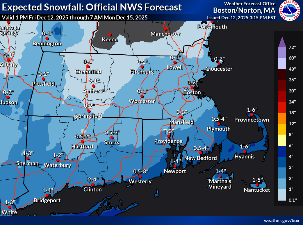
Did the person who does snowfall map ranges at BOX get shit-canned during the shut down? The ranges are noticably odd this year. Never saw 0" for the low range in the past with any number other than 1" as the top end of that range. Usually it was shown as < 1".Still appreciate the maps are published but it just makes my brain hurt to see things like 1-6"...


.thumb.jpeg.1d2958065f007d9e7218a8c935ea8246.jpeg)