All Activity
- Past hour
-

E PA/NJ/DE Spring 2026 Obs/Discussion
RedSky replied to PhiEaglesfan712's topic in Philadelphia Region
37F low -
Probably every summer in about 22 years ... Just another threshold moving on past ...
-
I wonder how rare Blowing Dust Advisories are in Illinois
-

Central PA Spring 2026 Discussion/Obs Thread
WmsptWx replied to Voyager's topic in Upstate New York/Pennsylvania
Starting to see a lot of SM posts about prolonged warmth, including the Pacific jet and MJO going into the warm stage. I'll take it. -
I can see/sense Brian's complaint on that. A cursory scan of the higher res vis satellite eyeballs an ~ 50 to 80% sun vs 50 to 20% cloud obstruction, yet you seem to be majority shaded over your neighborhood.
- Today
-
barry the goat
-
Are you on the top floor of a 3 story apt? My house was down to 60° this morning.
-
Did you need tissues like some here?
-
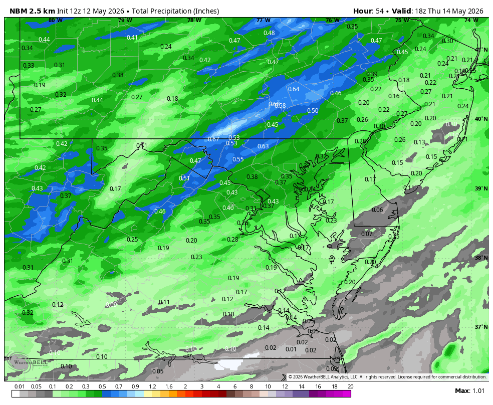
Take a Walk Warning in Effect.....get outside on this beautiful day. Hard to believe the rain forecast for tomorrow but hope it verifies for the NW burbs... WB 12Z NBM for midweek.
-

2026-2027 Strong/Super El Nino
snowman19 replied to Stormchaserchuck1's topic in Weather Forecasting and Discussion
The DWKW has started to surface and an “El Nino Costero” has developed off the South American coast in region 1+2: ^ Translation: “#El_Niño_Costero. Upwelling of warm waters along the central coast is evident, as is a significant increase in air temperature along the Lima coast, with temperatures today ranging between 26-31°C. SST anomaly reaches up to 5°C along the Lima coast.” -
I don't have AC yet..might need to be the weekend though. i'd go longer if i could leave the windows open, but now its pollen season.
-
I'm looking forward to seeing how they screw this up /s SHOULD take AJ Dybantsa, but I've heard if we can trade back with Utah, we can grab more draft capital, which they need in the worst way since they have so many holes to fill. AJ just could be a phenomenal talent to forgo this year. 6'9 and is basically NBA ready in a lot of ways. He could play at the 3/4 with AD at the 5 and Trae running point. That is a solid 3 with some of the talent they have already.
-

-
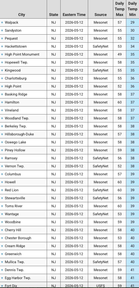
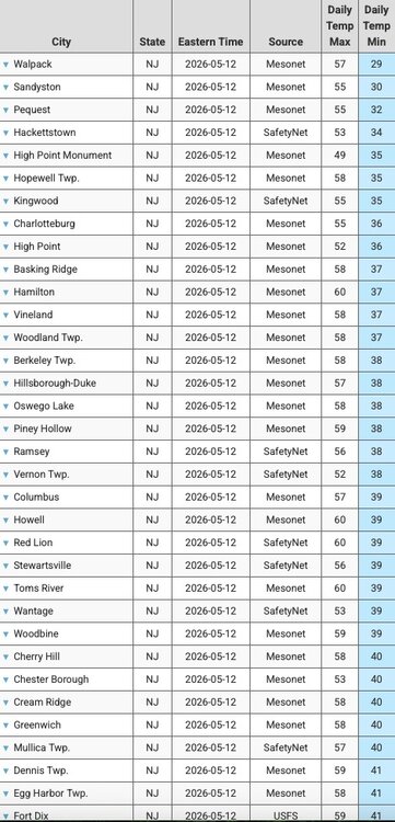
Sampling of the coldest NJ lows this morning. Likely not another morning with this kind of areawide chill until late September or October.
-
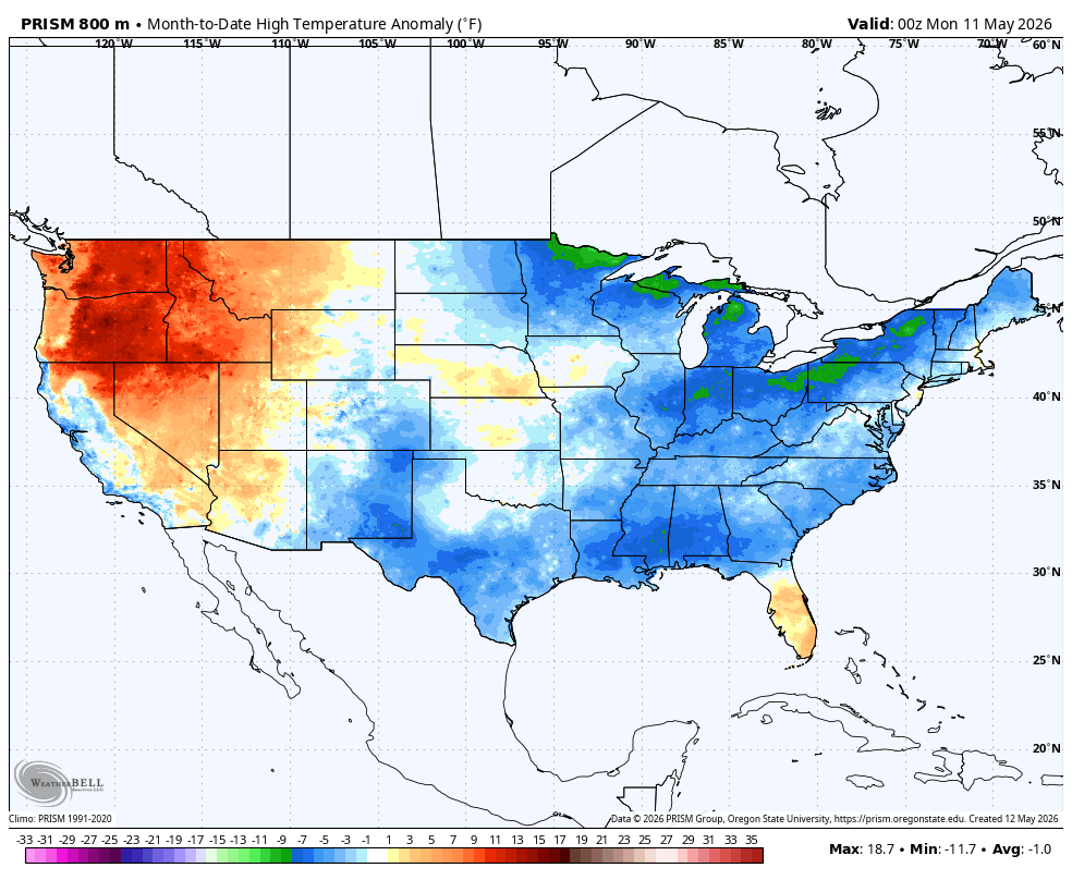
It has been a pretty cool May in the east, at least.

-
Had a window open here but no fan, ha. Nice crisp A/C like feeling.
-
I am dreading the return of the heat for next week but enjoying the nice days while they last.
-
A couple hundred foot difference in about a half mile was a 10° difference in the low temp, 40 vs 50. Looks like I got to 48.
-
Back when my wife was working in Royalston, during the early days of Covid, they had her school do a little teacher parade thing where we drove all through her district (it was so weird). I really got how sparsely populated some of those towns are (Warwick MA is so small!)
-
back in our wind era
-

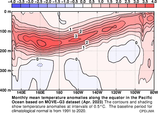
2026-2027 Strong/Super El Nino
bluewave replied to Stormchaserchuck1's topic in Weather Forecasting and Discussion
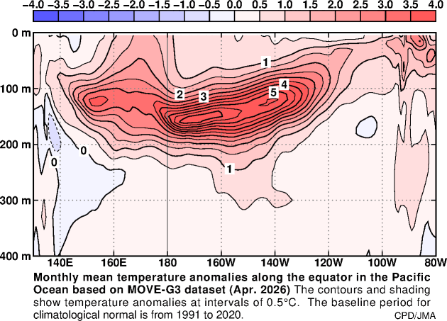
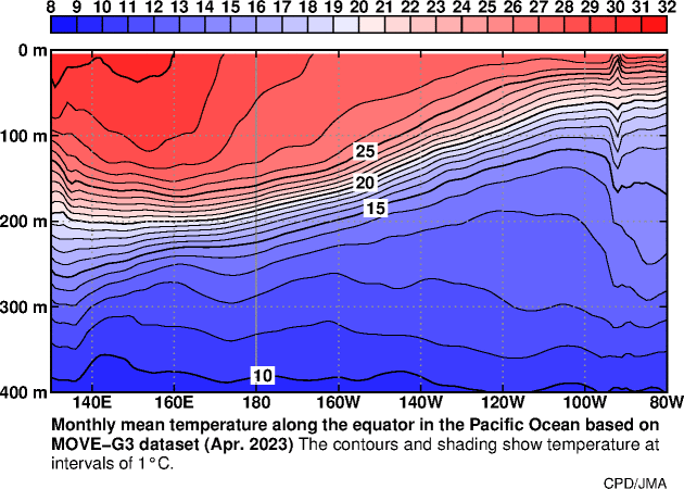
This is the first that the +30C warm pool near the Dateline made it down to 100m in April with a developing El Nino. Notice how much warmer in all aspects we are than 2023 during the same time. You have to wonder if this continues leading to a slower cold pool formation than we typically see toward the later stages of the El Nino in the Western Pacific. We probably wouldn’t know until next winter whether it could cause this one to wind down more slowly than usual during the spring.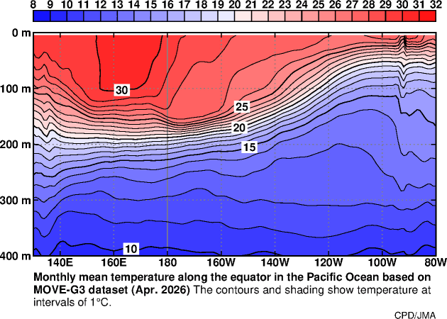
-
38 here. Maybe last 30s for a few months
-
All the runs seem light on Mon/Tue. The GFS is spuriously cooling the 850 mb between 15 and 21Z on Monday, between the Presidential Range and D.E.M., extending barely +10C down into interior SNE. There is no reason or cause that can be synoptically identified to do that. Meanwhile, the CMC has even lower ceiling level RH values, with no means to cool the 850mb ...but opts to keep the BL less mixed and (apparently) doesn't think the sun's strong enough to make the difference there - which is suss because if it is right about a hotter Sunday, the night's going to be elevated some ...setting up a higher Monday launch. So not likely on that - I didn't venture into the Euro ...I just figured it's upper 70s under general 566 to 570 dm hydrostats must be the conspiracy to hide CC from the model outputs showing up. haha.
-
Ended with 0.57" at 7 am reading, that makes event total 1.05". First plus one inch rainfall here since 2/20/26. Was 37.0 for a low, but saw no frost, likely due to the heavy fog that formed. Currently 45.7/42.0 at 9:50 am as the sun is burning thru the last of the fog.
-

Mid-Long Range Discussion 2026
WinstonSalemArlington replied to BooneWX's topic in Southeastern States