All Activity
- Past hour
-
It’s gone next week so we enjoy now.
-
72. Norway maples early stages of leafing out.
-
Feels like it, it has that late June morning vibe, but the chorus of birds and landscape screams Spring...
-
Some signs of a pattern change, but I fear this will just keep getting kicked back
.thumb.png.df086afdf9812134b5c57c403e0bdbd7.png)
.thumb.png.1ff034b5ea1e6d33de65034397d9fb82.png)
-
Today is a slog so far again. 58.9° and BKN skies
-
75 / 57 the 6.6 day strong warmup entering its peak mid 80s to low 90s in the area, with many records possible today- Friday. Cold front comes through at some point Sunday and could see a 30-40 degree swing from Sunday max to Monday lows (4/19) - (4/20). Storms could trend stronger for Sunday as well. Cooler next week with temps falling near to below noram as trough into the northeast - onshore flow backing in, we'll see if we turn wetter. Beyond there moderation as we approach early May. 4/13 - 4/19 : Warm to very warm +10 - +20 period, record warmth, first 90s, mainly dry 4/20 - 4/30 : Below normal overall - wetter 5/1 - beyond : Near normal - moderation
-
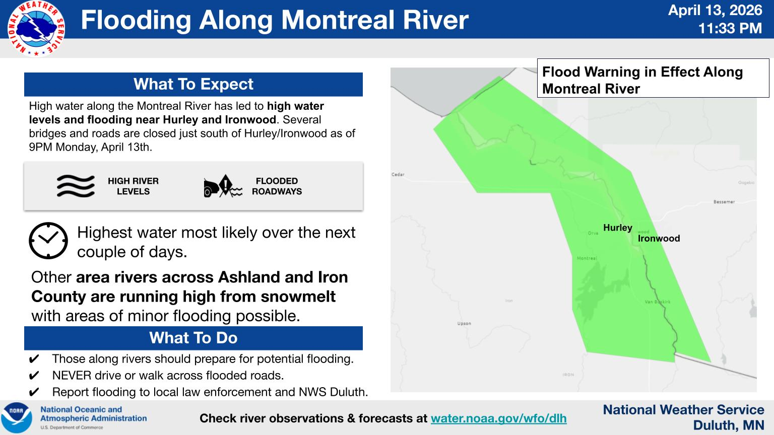
+DR(-RN) under overcast skies with a lake breeze and a 37 temp. ISH! But it is April (mud month). Most of the snow is gone except for some piles, and large drifts here in town. Montreal River over on the WI/UP MI border flooding right now, too, closing roads/bridges.

-
Rain shields holding strong through the end of the month
.thumb.png.c130a6a845e3c06b0c202e379064ff3a.png)
-
Agreed.
-
I think the big "concern" is clouds putting a lid on it... you could very well be right. Not bad for mid Napril
-
Man it’s summer
-

2025-2026 ENSO
PhiEaglesfan712 replied to 40/70 Benchmark's topic in Weather Forecasting and Discussion
Funny how my early February long-term forecast verified: People were mad about it, but I could see the cold was on borrowed time. We had 3 months of solidly below average temperatures. Were people really expecting it to last a 4th or even 5th month? I can't remember the last time a cold pattern lasted that long. The last time we even had 3 months of solidly BN temperatures was January-March 2015, and you saw what happened in April and May. This March and April are mirroring the warmth of April and May 2015, as I thought would happen. -

2026-2027 El Nino
LakePaste25 replied to Stormchaserchuck1's topic in Weather Forecasting and Discussion
Interesting. 1972 was one of the coolest summers on record here. -
Sunset in Dix Park in Raleigh:
-

Occasional Thoughts on Climate Change
Typhoon Tip replied to donsutherland1's topic in Climate Change
His linear, arithmetic approach to the question is not how nature works. He doesn't appear even aware of "synergy" in the system, emergent properties of complex systems that are wholly dependent upon the interactions of products, that cannot be very coherently pre- assessed or predicted because they do not exist until they are manufactured by the system. A+B --> A' C+D --> C' ; A' + C' --> A'' where A'' is the synergistic bi-product. If we really wanna roll sleeves in how nature works, A, B, C, and D, are all partial derivatives occurring in time - it's really more like d(A)+d(B) --> A' d(C)+d(D) --> C' ; d(A') + d(C') --> A'' We've been talking about this for years at this point in here. The increased frequency of 'extra special' heat waves, Globally, surpassing all predictive tools ( sometimes by very large margins ), have already been denoted as "synergistic heat waves" in various climate publications/among the compendium of accredited sources. There's probably going to need some discrete reanalytic study, but it's much more likely that the heat in the SW U.S. during March was a phenomenon of this ilk. -
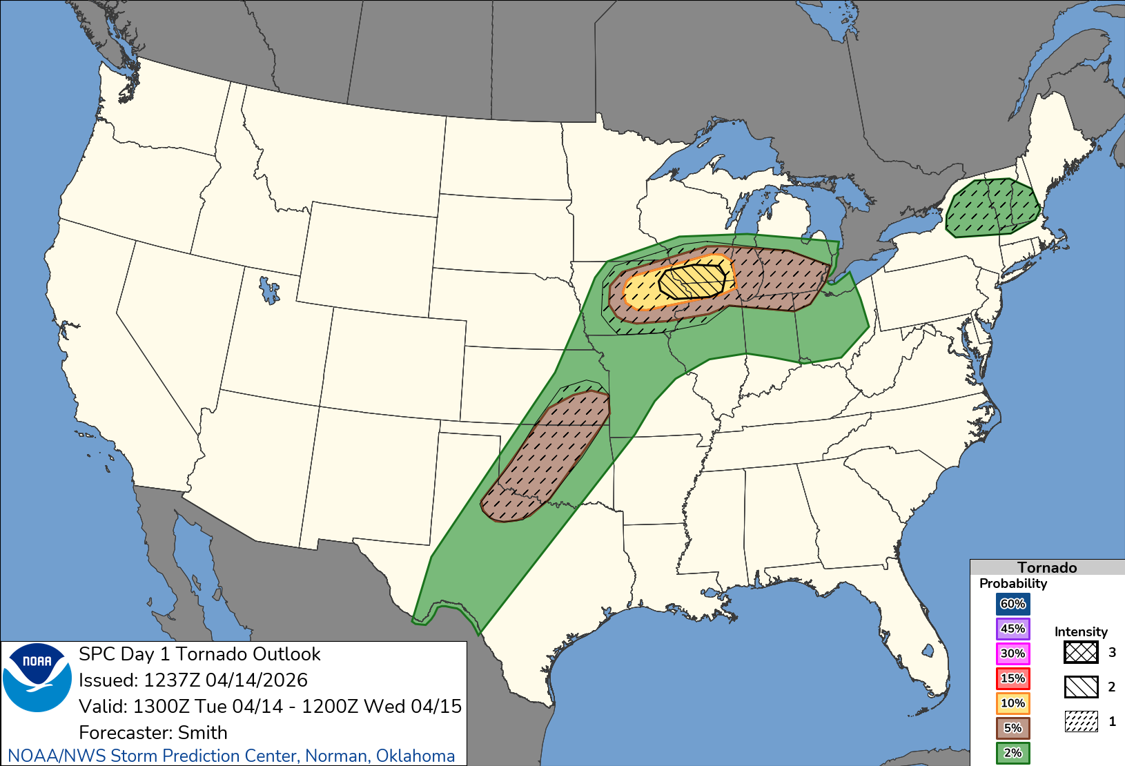
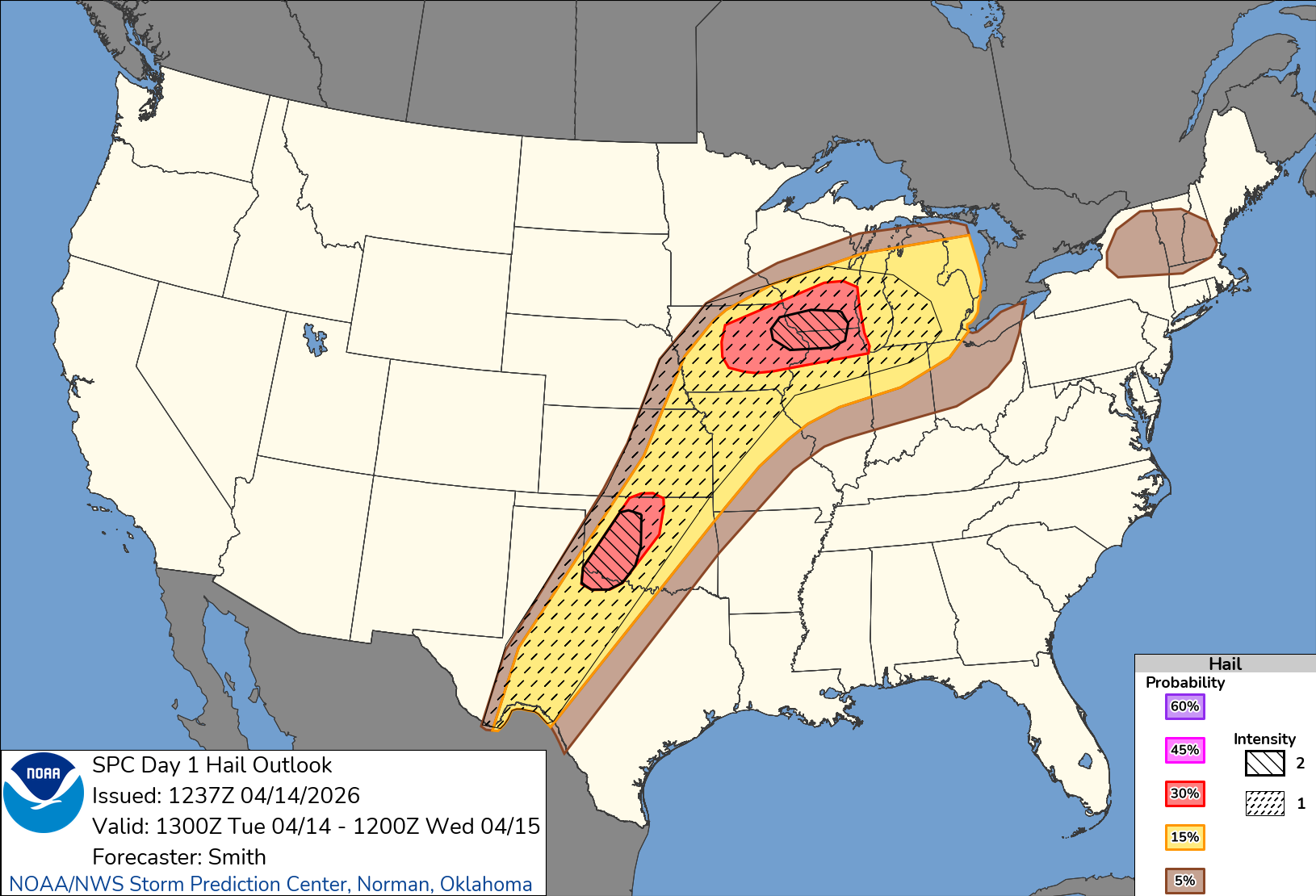
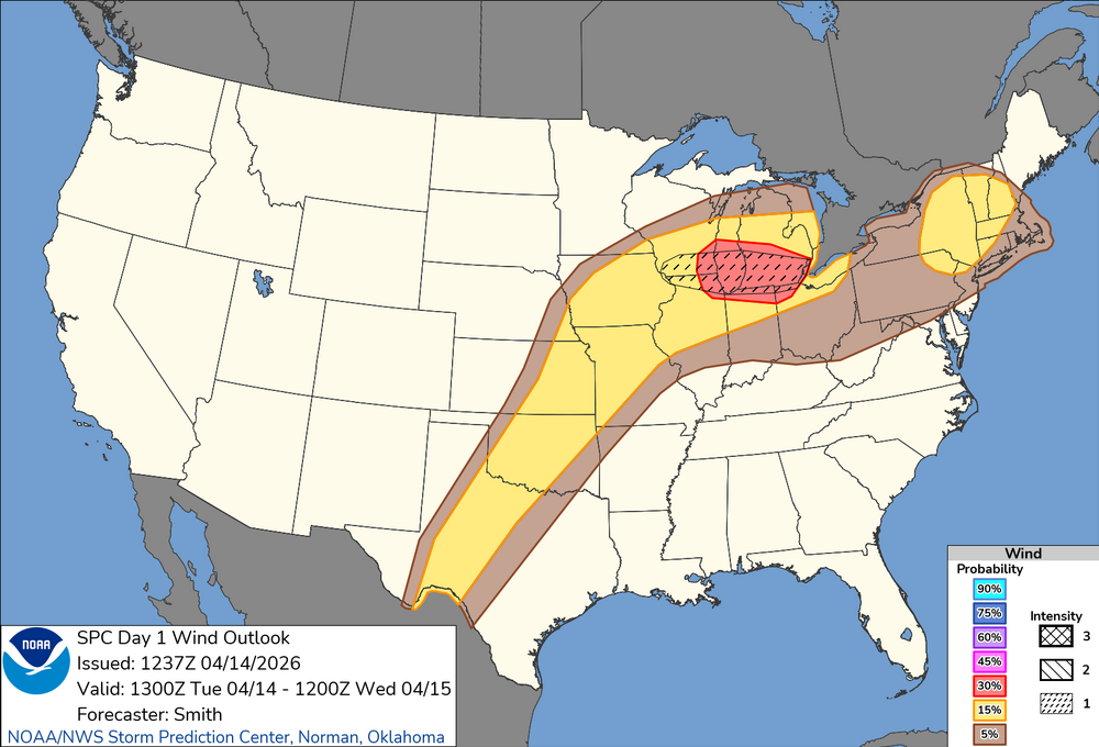
Tornado, wind and hail upgrades for today:


-

2026-2027 El Nino
snowman19 replied to Stormchaserchuck1's topic in Weather Forecasting and Discussion
“A strong MJO pulse (part of what helped spawn #Sinlaku) is traversing the Pacific and will move towards Central America. As a result, trade winds will slow across the Central and East Pacific in the next two weeks. I expect we will see some fairly rapid warming of ENSO 1+2 and ENSO 3 as a result, with a lot of sub-surface heat lurking from the last downwelling Kelvin Wave. On top of warming already ongoing, the East/Central Pacific may start to look very El-Niño-like shortly.” -
(002).thumb.png.6e3d9d46bca5fe41aab7a74871dd8af8.png)
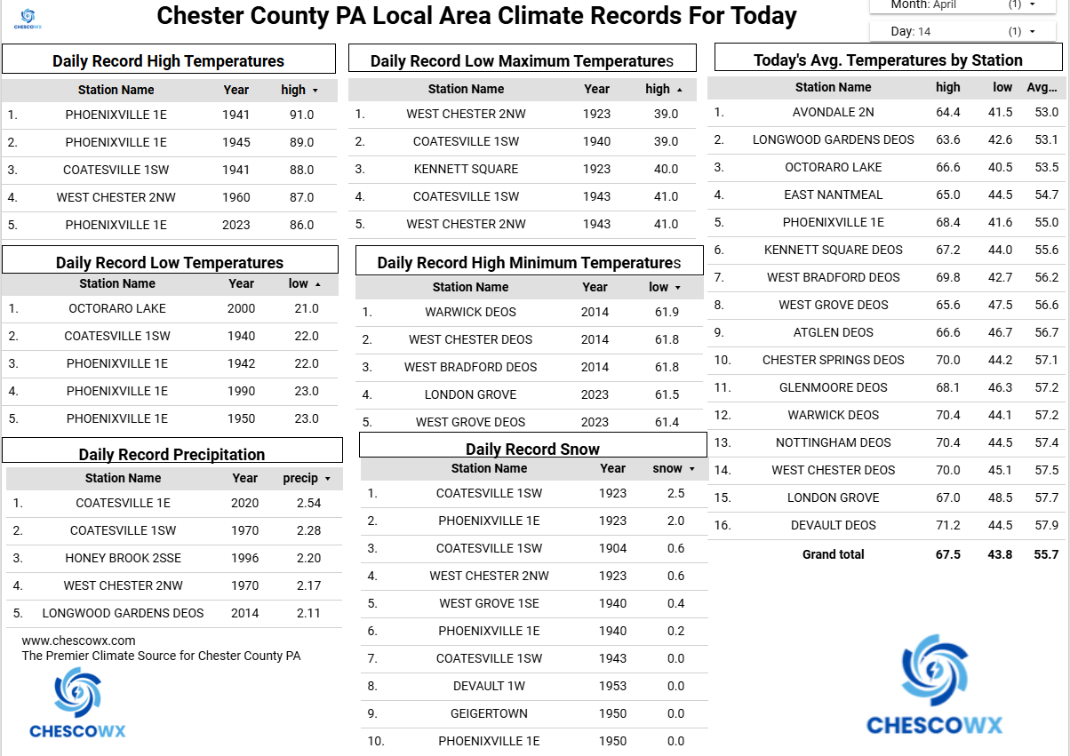
Central PA Spring 2026 Discussion/Obs Thread
ChescoWx replied to Voyager's topic in Upstate New York/Pennsylvania
Well above normal temperatures continue through Saturday before we see another pattern change to normal to below average temperatures lasting through much of the rest of the month. The warmest day looks like Wednesday with highs in the mid to upper 80's. Shower chances increase Friday night and especially Saturday night into Sunday with the cold front. Temperatures by next Monday may struggle to escape the mid-50's.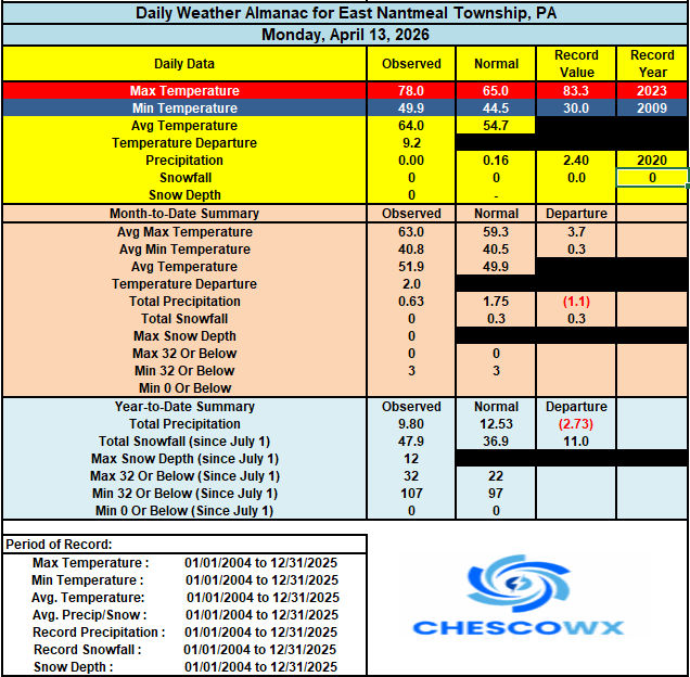
-
Enhanced risk expanded further east towards Detroit for wind and tornadoes ahead of the line while a cig 2 tornado risk has been introduced further west
-
E PA/NJ/DE Spring 2026 Obs/Discussion
ChescoWx replied to PhiEaglesfan712's topic in Philadelphia Region
Well above normal temperatures continue through Saturday before we see another pattern change to normal to below average temperatures lasting through much of the rest of the month. The warmest day looks like Wednesday with highs in the mid to upper 80's. Shower chances increase Friday night and especially Saturday night into Sunday with the cold front. Temperatures by next Monday may struggle to escape the mid-50's.
-
Update: it’s mid April and the cold is nowhere to be found, my area is expected to be 80 the next 3 days. I’m planning to install my AC tonight. Just a month and a half ago I was buried under feet of snow, kind of nuts how quick the seasonal transition was this year. Very warm start to spring.
-
2026-2027 El Nino
snowman19 replied to Stormchaserchuck1's topic in Weather Forecasting and Discussion
Given the totality of the indicators up to now, I think it goes super. Then the question becomes is it east-based/East Pacific (1997-98, 1982-83) or basin-wide (2015-16) -

2026-2027 El Nino
bluewave replied to Stormchaserchuck1's topic in Weather Forecasting and Discussion
If the models are still showing something similar with the June updates, then our first 2.0°+ ONI El Niño events within 3 years would become more likely. -
Landscaping should really start popping this week with the breaks of sun
-

2026-2027 El Nino
40/70 Benchmark replied to Stormchaserchuck1's topic in Weather Forecasting and Discussion
Important to see how the PDO evolves, too.....I don't think that it will, but if it were to remain negative with the RONI continuing to lag to ONI, then good night nurse.


.png.f874d318ea68977df13d85795cf42505.png)
.png.850aea734600ec84a18629b76fee4b1d.png)


.png.f51586f7735e1c389f201adb54d7da8b.png)