All Activity
- Past hour
-
Was great day to mow the grass for the last time this season! Will be swapping the garage for the Christmas decorations by the front door and the lawnmower packed in the back! 77 for a high today was quite warm! Probably do it again tomorrow!
-
Low once again of 43, high 76. Dew points climbed into the upper 50's but still a very nice day.
- Yesterday
-
Yeeeeah, put another way even simpler… As long as the climate curve is pointed up that intrinsically favors warmer than normal at all times. And so without any contravening indicator that are sufficiently loud even reasonable… they’re probably just gonna operate on that former basis
-

Spooky Season (October Disco Thread)
kdxken replied to Prismshine Productions's topic in New England
The mighty Pemi ! Not much depth to begin with. A lot of ass dragging spots. Took a date for her first time kayaking. She got caught in a snag and the kayak filled with water . She was screaming for help. Told her to stand up. No second date... But yeah that's dry... -

Central PA Fall Discussions and Obs
Chris78 replied to ChescoWx's topic in Upstate New York/Pennsylvania
Can you keep him north of the border please. -

Occasional Thoughts on Climate Change
donsutherland1 replied to donsutherland1's topic in Climate Change
Yes. Errors increase at greater depths. This data is reliable. -
Already up to 1.5”. Call looking good. What we’ve lacked in severe weather locally we’ve made up for in long-duration thunderstorms.
-
Spooky Season (October Disco Thread)
kdxken replied to Prismshine Productions's topic in New England
Nothing colder than a kid's soccer tournament. My daughter played in the South Shore League. Quincy, duxbury, situate, Hingham, not a warm town in the bunch In late fall. -

Central PA Fall Discussions and Obs
canderson replied to ChescoWx's topic in Upstate New York/Pennsylvania
74 was the high today. A warm one. -
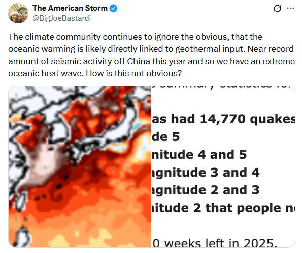
Thanks, Don. What you’re saying seems intuitive. Do you think these at depth SSTA maps can be trusted for accuracy?
-
Occasional Thoughts on Climate Change
donsutherland1 replied to donsutherland1's topic in Climate Change
More social media disinformation: The reality: Source of subsurface anomalies: CyclonicWx.com. I circled the depths and added the label to show what is occurring. were volcanoes responsible, SSTAs would be increasing at depth.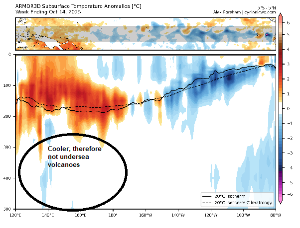
-
We hit 92 again today. FUCK! I am sick to death of summer in late October. I want cold with high winds. I want tons of rain, wind-whipped heavy torrential rain in 43 degree conditions, I want floods in EVERY low water region while I am trying to deliver at 0423 am. I want high winds and rain rain rain rain rain rain rain rain rain rain rain rain rain rain rain rain rain rain rain rain rain rain rain rain rain rain rain rain rain rain rain rain rain rain rain rain rain rain rain rain rain rain rain rain rain rain rain rain rain rain rain rain rain rain rain rain rain rain rain rain rain rain rain rain rain rain rain rain rain rain rain rain rain rain rain rain and frigid COLD weather and floods floods floods and mud so damn deep I get completely ENGULFED in it! I am sick and tired of this relentless 1930s dust bowl wasteland! I want severe Siberian fronts with captured Gulf of Mexico lows that dump rain for weeks, get captured and just flood the hell out of South Central Texas! I want my freezing COLD! I want my RAIN! I want my rightful Kerr County floods! I want my freezing cold mud!
-
Intuitively, makes sense and I agree. The MC is a tricky area for convection though and can play games sometimes. We'll see what modeling trends decide to do with it over the coming days. I suspect it will make it as well, but we'll see.
-
I didn't realize the SOI was positive or neutral in 2023-24 except for in January. What a weird winter.
-
https://twitter.com/WxTca/status/1979617306818003406
-
-
Not sure its an early read. It tends to happen more times than not in a Nina, probably in neutral ENSO as well. Anecdotally when we are in a Nino models tend to get more juiced as we get closer to an event. Not really too surprising when you think about the pattern tendencies.
-
if the MJO makes it to the west pacific(which, it shouldn't have too much trouble doing so) then the IPWP will be pushed further east in addition to upwelling some of the heat in the subsurface
-

E PA/NJ/DE Autumn 2025 Obs/Discussion
Birds~69 replied to PhiEaglesfan712's topic in Philadelphia Region
If you want to get back at flies do it now. They are very slow at reacting this time of year. You don't have to even try that hard. If it lands on your knee just slap it they barely move and usually not in time. Fire pit evening? AI: Yes, flies are slower in the fall because their body temperature is dictated by the environment, and the cooling temperatures slow down their metabolism and flight ability. As temperatures drop, flies become sluggish. -

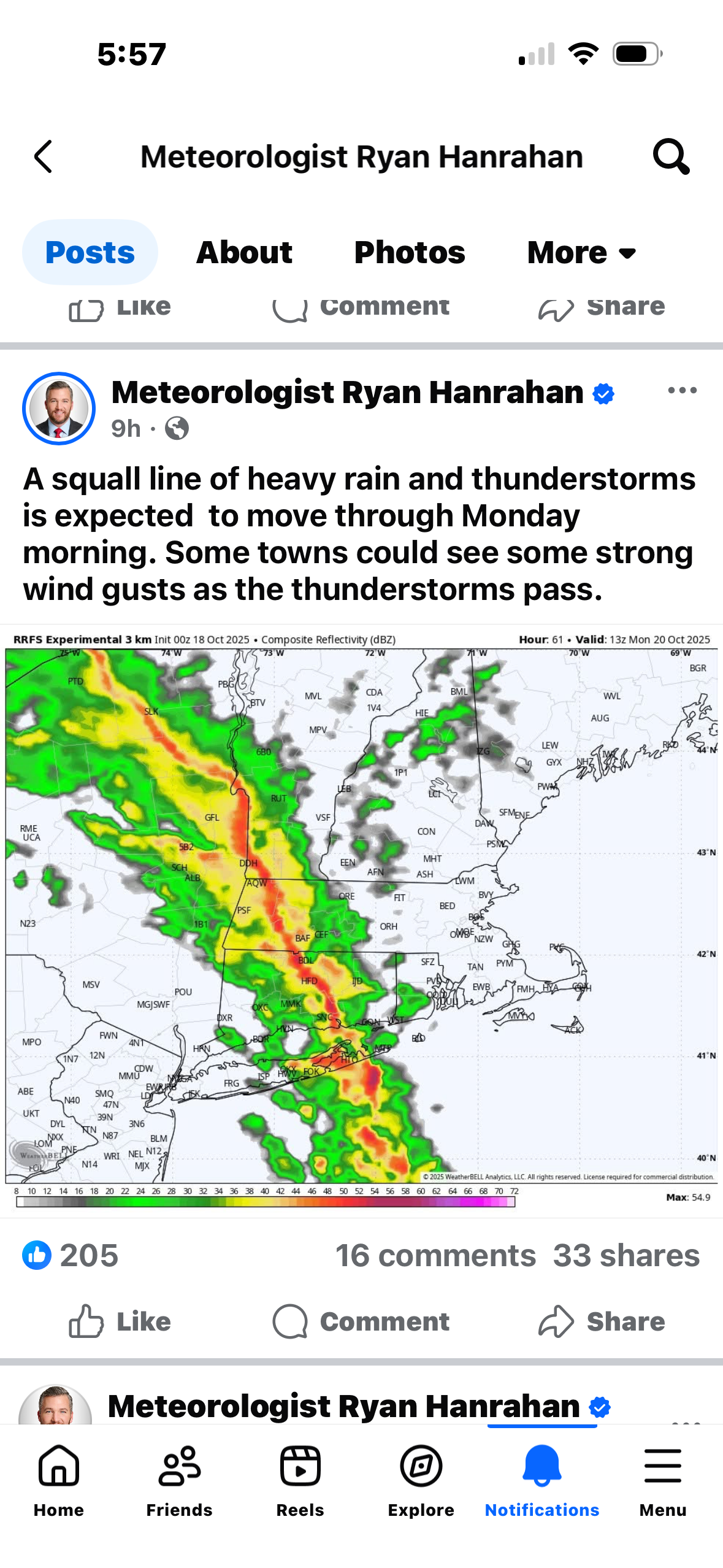
Monday, October 20, 2025 Squall Line Potential
Damage In Tolland replied to weatherwiz's topic in New England
Yup .. damage
-
I’m not sure it’s a true warm bias as much as there have been some absolute blowtorches in parts of the CONUS the last decade or so, and those are hard to pin down when ENSO seems to have a more muted impact? That said, the easiest call in wx seems to be winter warmth. I mean based on that graphic the last “cool” winter prior to last season was 2014-15. Ugly.
-

Monday, October 20, 2025 Squall Line Potential
Torch Tiger replied to weatherwiz's topic in New England
Looks light Could be a rumble or two of thunder with strongest shower activity but unfavorable time of day and shallow progged instability should limit this. Flow fields are pretty strong, with winds around 925 mb around 50-55 kt, but strongest jetcore is locked in a shallow inversion. Pattern looks similar to what we tend to find in late-Fall and the early-Spring with a strongly-forced line of downpours with brief gusty winds but limited severe weather potential. -
The weekend will end on a very mild note. Temperatures will reach upper 60s to perhaps lower 70s on Sunday. A cold front will move across the region tomorrow night. Low pressure will likely form along the front and move across the region. Periods of rain and perhaps some thunderstorms are likely into Monday. A general 0.25"-0.75" with locally higher amounts appears likely. Following the frontal and storm passage, temperatures will top out in the lower and middle 60s through midweek. A stronger push of cold air could arrive afterward. In the 18 past years where Central Park saw at least two 80° or above highs and Newark saw at least two 84° or above highs during the first week of October, the temperature returned to 70° or above on at least one day during the second half of October in 17 (94.4%) of those cases. For all other cases, 84.1% saw at least one such high temperature during the second half of October. Therefore, the sharp cool spell very likely won't mean that New York City has seen its last 70° or above high temperature. The ENSO Region 1+2 anomaly was -0.1°C and the Region 3.4 anomaly was -0.3°C for the week centered around October 8. For the past six weeks, the ENSO Region 1+2 anomaly has averaged -0.12°C and the ENSO Region 3.4 anomaly has averaged -0.42°C. La Niña conditions will likely continue through mid-winter. The SOI was +4.38 today. The preliminary Arctic Oscillation (AO) was -0.575 today. Based on sensitivity analysis applied to the latest guidance, there is an implied 63% probability that New York City will have a warmer than normal October (1991-2020 normal). October will likely finish with a mean temperature near 58.6° (0.7° above normal). Supplemental Information: The projected mean would be 1.7° above the 1981-2010 normal monthly value.
-
it will be in the 70s tomorrow, it was 68 here today
-
Had a low of 22.6 here and had to sit outside for a kids soccer tournament in Gorham 830 to 2. It was coooooold