All Activity
- Past hour
-
 Round 2 looking solid today
 -
January 2026 regional war/obs/disco thread
Damage In Tolland replied to Baroclinic Zone's topic in New England
We are back -
Looks like the trough/sw is backing west, eliminating some OTS possibilities. But we'll just have to see how far west it backs until they hone into something that's close to a solution. The storm yesterday - the NS wave and the phase kept backing west for days, and for a couple days it was at the sweet spot for us, and then it still kept backing west.
-
Not there, but headed in the right when comparing 0z to 6z.
-
Hours and hours of mist at 14° did a good job of locking in whatever wasn't shoveled. Fugger, this sux to shovel Now it's snowing lightly and covering everything again too.
-
 Was more interested in a final report from Newport. Around 12?
 -
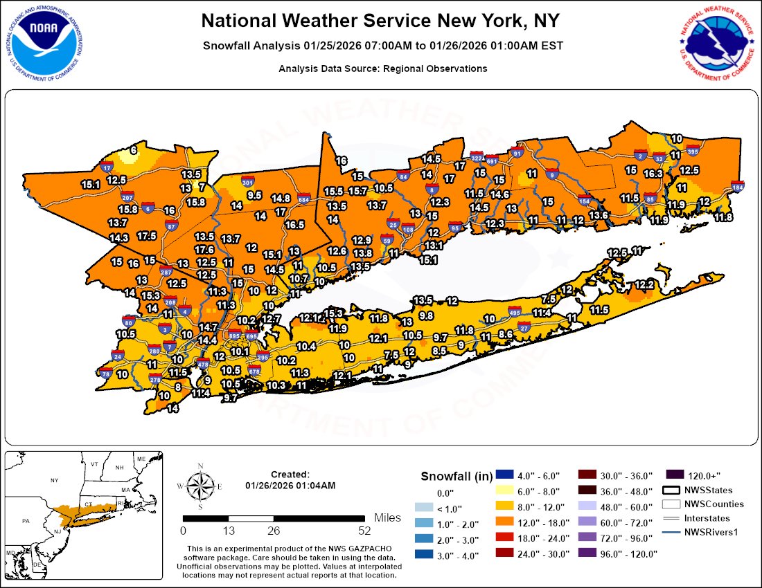
 13 inches Branford.
-
 Just measured 3 spots.. 16,16,17 im sure it compacted some and not sure how accurate with the blowing snow around
 -
 Just walked the dog.....my street is entirely a drift. Not surprisingly, my deck is entirely snow-free. I think all the snow that had come down on the river-sde of the house has been relocated to the front and to other's houses up the street. Fun little storm.
 -
I am up to 22.5 inches for the winter.
-
Temp falling 23F Pressure rising 29.60 Final freezing rain total according to the weather system .42"
-
dude they never plowed gregg hill It's still 1 ft of snow But so light and fluffy it's delightful I will share video, but I have lived here since 1987. I have never seen a road as unplowed as this, well closed class 4 maybe. They never made a pass today at all
-

E PA/NJ/DE Winter 2025-26 Obs/Discussion
Albedoman replied to LVblizzard's topic in Philadelphia Region
This would cause this biggest G dam flood and end in chance of a drought for a year. 96 all over again. I am done with snow for awhile. A federal disaster would have to be issued and the resulting melt and thaw with any rain over a couple of inches would blow out every fricking bridge on the Delaware. Next big worrk folks other than this BS run of the Euro, ice jams. The base flows are low in the streams, nearly 2ft of snow on the ground north of S Mtn and 3-5 days of below zero weather and highs not even cracking 26 degrees. The Delaware, Lehigh and especially the Susquehanna are frozen over now or close to it. The media is going to go crazy. I did not say Schulkill because the cooling waters from the industrial treatments plants from Limerick ,Oaks and Reading may keep the water warm enough in that river from freezing over. -
My cous received 25,5 in pearl river nice .
-
Icon might of been trying to do naught things
-
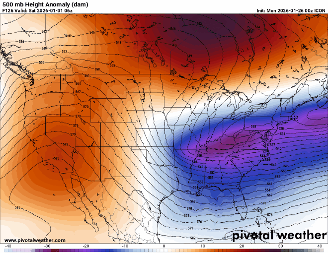
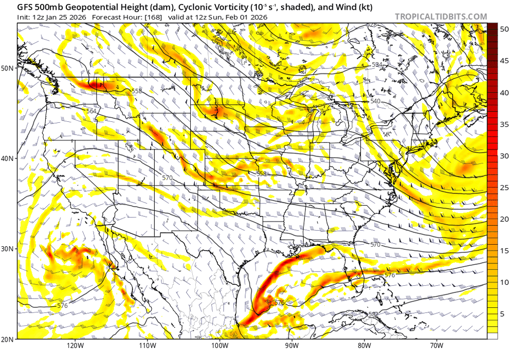
Yeah, next weekend looks like another system with the Euro AI taking the lead. It had this weekends system coming up the coast while the OP Euro and EPS and GFS and GEFS were too suppressed. The GFS and GEFS were the most suppressed. The EPS-AIFS and AIFS single were first showing next weekends system more defined and just offshore last few days while the OP Euro and EPS and GFS were more suppressed. The 0z guidance now has the ridge and trough axis further west allowing the trough to go negative tilt quicker for the benchmark Miller A Southern Stream KU potential. It would be wild if the 10 year major KU snowstorm pattern in January 1996, February 2006, January 2016, and February 2026 worked out. EPS-AIFS and AIFS single are now the highest scoring models

-
Gfs is just offshore
-
 11” of sparkling fluff. Still snowing.
 -
Lol couldn’t have been more wrong. 10-11” of total air.
-
Well it's not gonna get there yet, but 5H continues to improve.
-

NNE Cold Season Thread 2025-2026
EMontpelierWhiteout replied to Boston Bulldog's topic in New England
10” storm total as of 4:45 AM. I measured 3.75 at 9:30 last night, so 6.25 over 6 3/4 hours. Beautiful fluff. Like walking through air! -
Also some time of freezing drizzle.
-
I slept like a baby and I'm headed out to chisel my jeep out of its encasement and try to get to wok lol. This may have been posted but no time to browse 20 pages. This is pretty tasty and close enough for a mean at this range. Like I said last night there is plenty of time for guidance to correct any possible errors with the key features, and we all know nothing is ever nailed 5+ days out. More changes likely to come.
-
January 2026 regional war/obs/disco thread
moneypitmike replied to Baroclinic Zone's topic in New England
Nothing gets me more excited than a Miller A. If it's 6 hours out. -

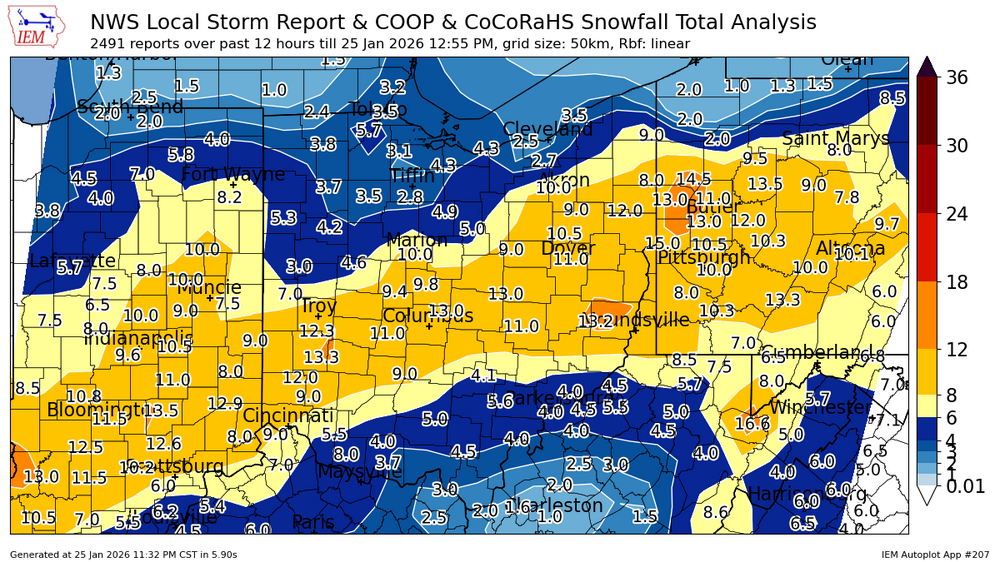
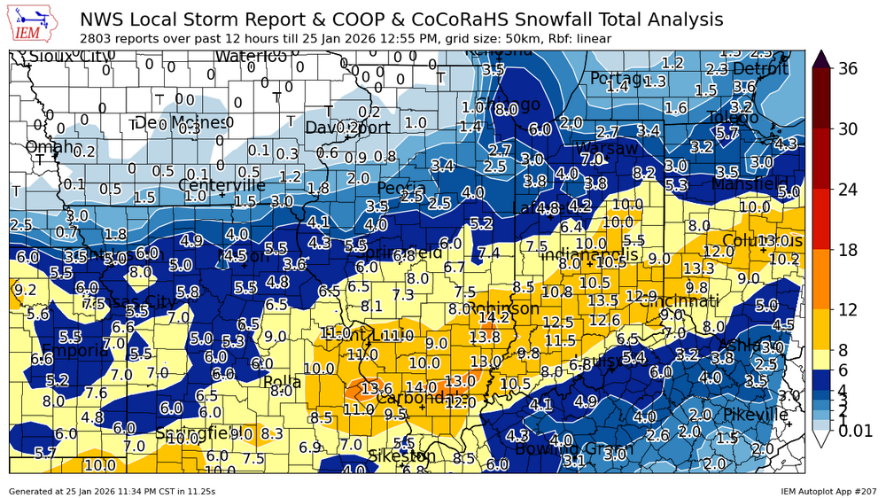
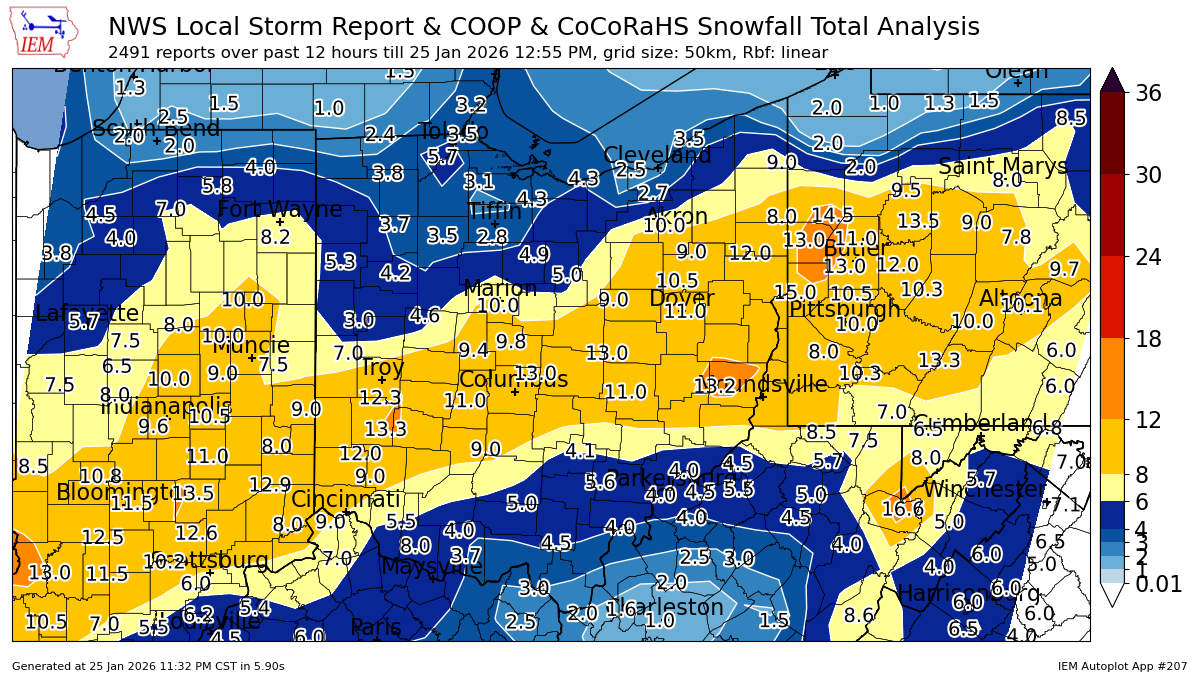
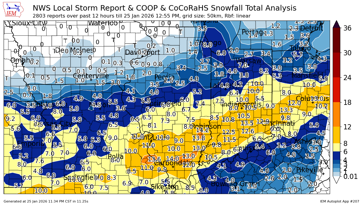
1/24-1/25 Major Winter Storm - S. IL, IN, and OH
Cary67 replied to A-L-E-K's topic in Lakes/Ohio Valley