All Activity
- Past hour
-

“Cory’s in LA! Let’s MECS!” Jan. 24-26 Disco
RUNNAWAYICEBERG replied to TheSnowman's topic in New England
Call the school so they can relay that to Bryce. He’ll have a better day… -
1.0”/0.04” of pure fluff
-

“Cory’s in LA! Let’s MECS!” Jan. 24-26 Disco
Great Snow 1717 replied to TheSnowman's topic in New England
The push for ratings has begun lol -
.thumb.jpg.6a4895b2a43f87359e4e7d04a6fa0d14.jpg)
Central PA Winter 25/26 Discussion and Obs
Yardstickgozinya replied to MAG5035's topic in Upstate New York/Pennsylvania

-
I think it had been so long since our whole collective group had tracked a storm, we forgot the cardinal rules of tracking a storm in the south. Funny thing is it wasn’t just us. NWS, Local TV Mets, Weather Channel were all honking the horn on Monday. Heck the Weather Channel showed graphics all day Tuesday of 12-24” across NC.
-

“Cory’s in LA! Let’s MECS!” Jan. 24-26 Disco
Typhoon Tip replied to TheSnowman's topic in New England
Okay... for the first time I'm impressed by the model solutions overnight. 1 to 1.5' (that's feet) of snow "precipitating" out of a modeling consensus that frankly ... could be underdone considering the feeding circumstances into this whole thing. This is running an anomalously rich subtropical sourced air up underneath an impressive if not historically cold air mass intrusion currently just entering the NP ... continues to load into everywhere N of roughly Enid Oklahoma to Va Beach - obviously colder N within that immense region. Meanwhile, a starkly opposing air mass is bulging back N from southern TX across the Gulf inteface with the continent down there. As an aside, this really looks like a battle between well established and sufficiently time laged MJO Phase 6 modulation, correlated temperature/moisture bias, which is rich in the OV/TN region, where incongruously ...we find mammoth cold invasion setting up. Thus, an immense conflict at both larger teleconnection scaled correlations, as well as what is physically being actually observed. And here I've been focused on the 29-02 dates ( and still am interested in that range, btw ). I kind of missed this I think. If I'm being totally honest. I see this now as a planetary. What I mean by that, it is rooted in all these super structures ... modulations that have come into larger scaled conflict set to take place. This is a WHOPPER of a correction event. Ginormous opposing planetary signals set to resolve their differences, impacting half the country to do it. About the only con to this happening as such at this point ... we have to keep in mind that everything described/analyzed above is based upon the virtual plot/movie history of the guidance. They could be telling the wrong story... I see that as less likely - shy of moderating impacts in areas and back yards, the whole of thing in manifested out of these root observations about the state of the larger environment. That's a clue to deterministic comfort when that is the case. Something has to correct this mess, we have model solutions capable of doing it. There's not much else we can do. -
 28F thru storm in NYC. Much warmer than this storm. Much
 -
Yeah not worried about mixing unless we slot and it gets to 34 with snizzle. Big deal.
-

Possible Record Breaking Cold + Snow Sunday 1/25 - Tuesday 1/27
MJO812 replied to TriPol's topic in New York City Metro
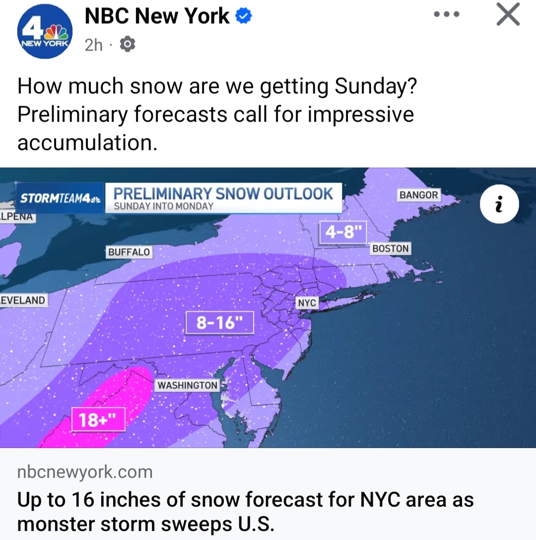
NBC lol
-

Possible Record Breaking Cold + Snow Sunday 1/25 - Tuesday 1/27
allgame830 replied to TriPol's topic in New York City Metro
And if that happens we probably dont dryslot and the whole area stays all snow like you said -
Central PA Winter 25/26 Discussion and Obs
Yardstickgozinya replied to MAG5035's topic in Upstate New York/Pennsylvania
F*** waiting. Temu's hot air balloon includes a handmade basket and torch, for only $49.99. -
I don't wish this forecast on anyone. We could get 3'' or we could get 9''. The biggest dilemma is trying to nail down PL vs ZR. That is where i'm conflicted. Gun to head I think your area sees 3-6" followed by a prolonged period of PL and then finishing it with a ZR topper.
-
Looking back at the thread it’s comical how naive and stupid we all sounded. Did we really believe a near 1,000 mile long stretch of overrunning was possible? Even more hilarious, every single one of us took the bait on the 1050+ HP.
-
If these NWS offices would just forecast snow, we would get it. Thats how it works right?
-

January 24-26: Miracle or Mirage JV/Banter Thread!
NorthArlington101 replied to SnowenOutThere's topic in Mid Atlantic
@yoda something in your settings says you can't receive PMs - hoping to see you (and anyone else here) at Succotash DC sometime between 5-7pm! I'll be in a pink button-down. If anyone wants to join and wants my cell #, message me. -

Possible Record Breaking Cold + Snow Sunday 1/25 - Tuesday 1/27
SACRUS replied to TriPol's topic in New York City Metro
EPS mean 850 MB -
1000% agree... I mentioned yesterday how negativity seems to overwhelm even when a good old fashioned storm develops!
-

Possible Record Breaking Cold + Snow Sunday 1/25 - Tuesday 1/27
NEG NAO replied to TriPol's topic in New York City Metro
if the low transfers to the coast that far south we will have all snow IMO -

January 24-26: Miracle or Mirage JV/Banter Thread!
BlizzardNole replied to SnowenOutThere's topic in Mid Atlantic
I'm amazed by how cold it looks for days and days after this event! Imagine if something pops up in medium range next week like a strong clipper. Or if we get one of those deals where a big system forms as the cold pattern starts to relax. -
I think I used to work with wildre's ex-gf
literally nothing else interesting happening here except cold rain
-

MO/KS/AR/OK 2025-2026 Winter Discussion
NWAflizzard replied to stormdragonwx's topic in Central/Western States
Tulsa upgraded to Winter Storm Warnings! 6-12 inches north of I40. Blowing and drifting snow possible. -

Pittsburgh/Western PA WINTER ‘25/‘26
Burghblizz replied to Burghblizz's topic in Upstate New York/Pennsylvania
lol - rage bait. Yeah, I had to do a double take at the timeframe. I really do think though it’s because they don’t want to put out a map that extends more than 72 hours out. -

January 25/26 Jimbo Back Surgery Storm
NorthHillsWx replied to Jimbo!'s topic in Southeastern States
Also less QPF. Might save us here in Raleigh -
Hrrr at max
.thumb.png.18f2b4618e38bdf237fc1a635e2f03e4.png)
-
Gonna put my flag in the sand on something though: moisture is always ahead of schedule. My thoughts are that we get a front end thump earlier on Saturday that gives us 1-2”.


.png.bd6a8664bea2722157867b994de59a6b.png)