
All Activity
- Past hour
-
 What a putrid looking sky.. someone tell hippy to put the giant bong down so we can all breathe easy again!
 -
.thumb.gif.f92b16c631a1d15d405ed77b33f0710d.gif) Yeah smoke lessened some, up to 89
Yeah smoke lessened some, up to 89 -
 88/71 here ..suns stronger as well. Won't verify advisories ... but it's still warm. - actually, it appears they've canceled headlines
 -
90/99
-
 90f denied. High 79f Sent from my SM-S921U using Tapatalk
 -

Mid-Long Range Discussion 2026
WinstonSalemArlington replied to BooneWX's topic in Southeastern States
-
 83 here. The dews are the real deal though. 73F on local Davis stations. I know that is probably off a bit but still
 -
97 at Toronto -Pearson
-
Probably not too much of a leap to think that the smoke might be holding temps back a bit.
-
Scary stuff
-
 Smoke is clearing out of CT now. BDL should run up to at least 93-94 next few hours
 -
 Blast furnace w/ BOS now G32kt?
 -
Interesting read about what happened to Earthlight. https://people.com/healthy-36-year-old-reveals-warning-signs-before-suffering-widowmaker-heart-attack-exclusive-12018433?taid=6a5558621fb3140001d6dcb4&utm_campaign=peoplemagazine&utm_content=new&utm_medium=social&utm_source=twitter.com
-
Interesting read about what happened to Earthlight. https://people.com/healthy-36-year-old-reveals-warning-signs-before-suffering-widowmaker-heart-attack-exclusive-12018433?taid=6a5558621fb3140001d6dcb4&utm_campaign=peoplemagazine&utm_content=new&utm_medium=social&utm_source=twitter.com
-

July 2026 General Discussion
TheClimateChanger replied to Chicago Storm's topic in Lakes/Ohio Valley
MKE was 97F at the last METAR observation. Up to 98F/99F now, per 5 minute observations. Last ob was 99F. Due to rounding probably only 98F, but definitely above 97F. -
 -10 degree temp bust here smoke 'em if you got 'em
 -
At least the smoke is at higher altitudes today than close to the surface back in 2023. It will be interesting to see if it can prevent the 100°+ that was forecast for tomorrow at the usual warm spots across the region. While these HRRR smoke plume forecasts change from run to run, they do indicate the potential for more smoke near the surface by later Wednesday into Thursday.
-
 Well before my time, so I don't know. But Canadians have dual-pol as well, so TDSs are possible to observe. I'm pretty sure I've seen a couple outside my forecast area.
 -

2026-2027 Super El Nino
snowman19 replied to Stormchaserchuck1's topic in Weather Forecasting and Discussion
All one has to do is look at these current anomalies and sea level heights/thermocline and there should be no question that this is going to be an all-time historic Nino event -
92/78.
-
 All the hail that has fallen on our yard in 28 years (going on 29) would fit in a 2-pound coffee can. I was sad to have missed the 2007 storm, but happy that I still had a garden.
 -
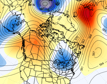
Yeah ...ensembles means are not likely to be as deep as operational versions at this range. It's just logic. If you have a pool of members, there's apt to be some that are always less - that weighting skews the mean... duh. So when the operational are that deep, the ensembles look like this, below - which is consistent with their summer +PNA during that time range. Which is still cold for warm enthusiasts unfortunately
-
Having the Doppler radars now in Canada really helps for NNE radar coverage, esp. since CXX is practically useless ern semicircle. It still amazes me that the NWS was not allowed to put the CXX radar on a mountain top when it was installed in the late 90s. This action thumbs its nose at protection of lives and property, and should override anything else in this case. Was that due to VT State Regulations about towers on mountain tops? It wasn't always that way, right? Mt Mansfield has communication towers.
-
Correct me if i'm wrong, but wouldn't this be like "block out the sun for a few hours" kind of stuff in Michigan?
-
Wow, great reports! "Leaf salad," LOL. It is amazing how efficient large hail is shreding trees very quickly!










