All Activity
- Past hour
-
Sunset coming through the clouds to my west from little ferry.
-
Who cares about wind. NYC was getting 20% of its power from a clean source immune to global price shocks that provided baseload power 24/7. But no! We had to shut that down! My bills are pushing DOUBLE what I paid 5 years ago. And I got much more efficient heat pumps installed mind you! Don't get me started.
-

E PA/NJ/DE Spring 2025 Obs/Discussion
RedSky replied to PhiEaglesfan712's topic in Philadelphia Region
Seeing streams out of banks today could have used some flood guy input -
0.88 today
-

OBS for OKX Flood Watch (attached) into early Saturday 5/10/25
IrishRob17 replied to wdrag's topic in New York City Metro
Radar not showing it but light rain continues, 2.43" with .05" in the last hour. -
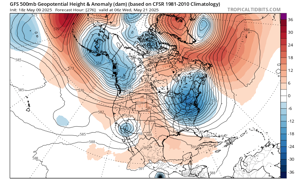
Showers and periods of rain are likely through at least the first half of tonight. A general storm total 0.50"-1.50" rainfall is likely with some locally higher amounts by the time all of the rain winds down. Following the weekend, it will turn warmer and possibly drier. Some showers will be possible Tuesday night into Wednesday. The ENSO Region 1+2 anomaly was +0.1°C and the Region 3.4 anomaly was -0.1°C for the week centered around April 30. For the past six weeks, the ENSO Region 1+2 anomaly has averaged +0.68°C and the ENSO Region 3.4 anomaly has averaged -0.05°C. Neutral ENSO conditions will likely continue through at least early summer. Early indications are that summer 2025 will be warmer than normal in the New York City and Philadelphia areas. The potential exists for a much warmer than normal summer (more than 1° above normal). The SOI was -13.16 today. The preliminary Arctic Oscillation (AO) was +1.412 today. Based on sensitivity analysis applied to the latest guidance, there is an implied near 78% probability that New York City will have a warmer than normal May (1991-2020 normal). May will likely finish with a mean temperature near 66.0° (2.8° above normal). That would tie 2025 with 1986 as the 9th warmest May on record.
-

-
37 here this morning. Last sub 40 day until October? lol
-
It is amazing how “stuck” our weather patterns have become lately. On both ends: dry and wet.
-
Drought! Flood Watch National Weather Service Gray ME 157 PM EDT Fri May 9 2025 .A slow moving low pressure system with plenty of moisture will affect the flood watch area through Saturday with periods of soaking rainfall. Wet antecedent conditions across New Hampshire and western Maine could allow for possible flooding late tonight through Saturday night, with one and a half to three inches of rain expected. MEZ013-018>020-023-024-033-NHZ014-100800- /O.EXA.KGYX.FA.A.0002.250509T1800Z-250511T0400Z/ /00000.0.ER.000000T0000Z.000000T0000Z.000000T0000Z.OO/ Southern Franklin-Interior York-Central Interior Cumberland- Androscoggin-Coastal York-Coastal Cumberland-Interior Cumberland Highlands-Coastal Rockingham- Including the cities of Harrison, Livermore Falls, Hollis, Gray, Limington, North Windham, Yarmouth, Sabattus, Portsmouth, Seabrook, Goodwins Mills, Farmington, Old Orchard Beach, New Gloucester, Temple, Lebanon, Greenland, Saco, North Hampton, Wales, South Portland, Wilton, Turner, Biddeford, Naples, Portland, Rye, Jay, Chesterville, Bridgton, Berwick, Westbrook, Gorham, Sanford, New Sharon, New Vineyard, Buxton, Auburn, Lewiston, Alfred, Greene, Minot, Cape Elizabeth, Brunswick, Hampton, Kittery, and Hampton Falls 157 PM EDT Fri May 9 2025 ...FLOOD WATCH IN EFFECT THROUGH SATURDAY EVENING... * WHAT...Flooding caused by excessive rainfall continues to be possible.Saturated ground with additional rainfall expected through tomorrow morning will create risk for flooding. * WHERE...Portions of Maine, including the following areas, Androscoggin, Central Interior Cumberland, Coastal Cumberland, Coastal York, Interior Cumberland Highlands, Interior York and Southern Franklin and southern New Hampshire, including the following area, Coastal Rockingham. * WHEN...Through Saturday evening. * IMPACTS...Excessive runoff may result in flooding of rivers, streams, and other low-lying and flood-prone locations. Flooding may occur in poor drainage and urban areas. PRECAUTIONARY/PREPAREDNESS ACTIONS... You should monitor the latest forecast and be alert for possible Flood Warnings. Those living in areas prone to flooding should be prepared to take action should flooding develop. && $$
-
Other than today and that nasty week in Napril .. this has been one hell of a nice and warm spring. The early leaf out and lawns agree
-
Some of the high schoolers were hoping yesterday that we’d have enough rain to cancel today.
-

Spring 2025 Medium/Long Range Discussion
Jackstraw replied to Chicago Storm's topic in Lakes/Ohio Valley
Yeah, I saw an 87 out in weenie land on my P&C. Not ready, never ready until after Memorial day, then bring it because its only gonna last 4 months at most by then -
2" since yesterday and still raining. 5+ for the week.
-
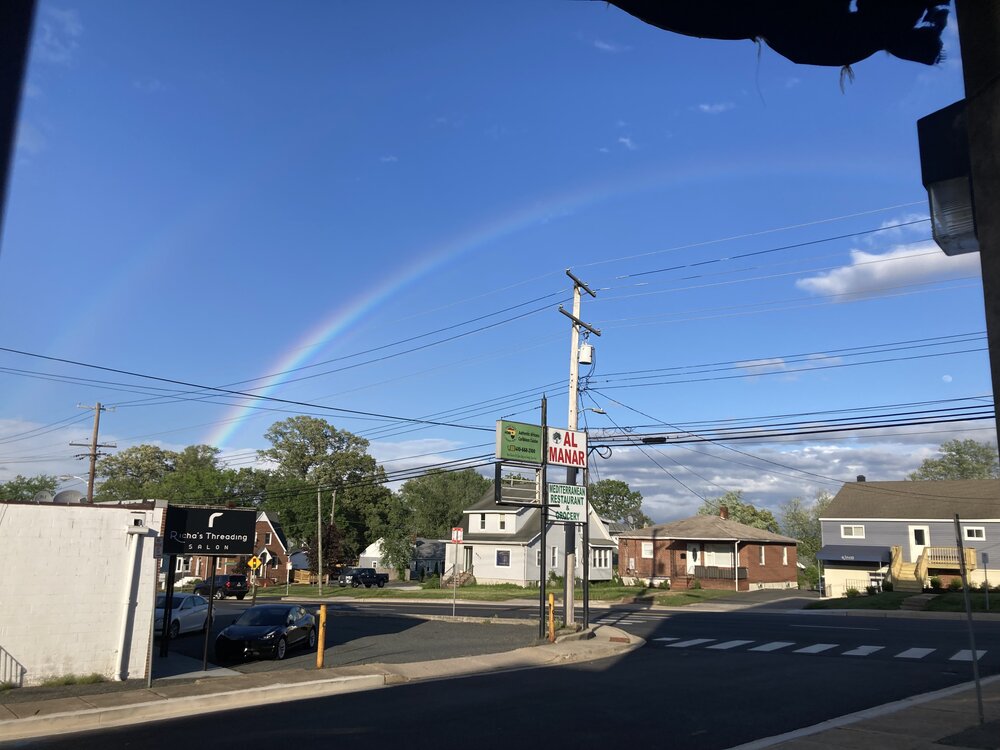
Parkville rainbow
-
And looks that way again next weekend.
- Today
-

E PA/NJ/DE Spring 2025 Obs/Discussion
Birds~69 replied to PhiEaglesfan712's topic in Philadelphia Region
And caring is sharing... 56F -
Yeah it’s been terrible up here. A couple of random nice days during the work week, but rusty coat hanger weekends.
-
E PA/NJ/DE Spring 2025 Obs/Discussion
Birds~69 replied to PhiEaglesfan712's topic in Philadelphia Region
Pretty sure he has a second job as flood guy from reading one of his previous post... 56F/Cloudy -
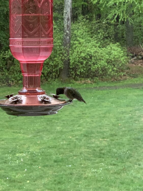
Hummingbirds don’t seem to mind the monsoon! Perfect day for a little sugary top off.
-
Maybe down there, Its sucked up here, I can't even mow my 6-12" lawn and more rain overnight into tomorrow, Maybe we dry out a few days next week finally.
-
Outstanding in fairness ... Those of us middle aged know this cannot possible compare to those Aprils of the 1955 through about 2010 ... And the Mays of 2018 -2022 were peculiarly bad, too... I must amid, grudgingly, that this immediate last April was an over achiever
-
May 09 , 2020 vs today about same spot looking up towards neighbors yard. Just small differences. Glad we now vs then .
-
“Backlash” rain coming through. Light to moderate shower, maybe it’ll get me to 0.6”.
-
It’s been nice other than first half April