All Activity
- Past hour
-
2025-2026 Fall/Winter Mountain Thread
cold air aloft replied to Buckethead's topic in Southeastern States
I still think this turns out to mostly a snow event from I-85 north. -

Pittsburgh/Western PA WINTER ‘25/‘26
Rd9108 replied to Burghblizz's topic in Upstate New York/Pennsylvania
These maps are crazy. I like that the precip shield is so big.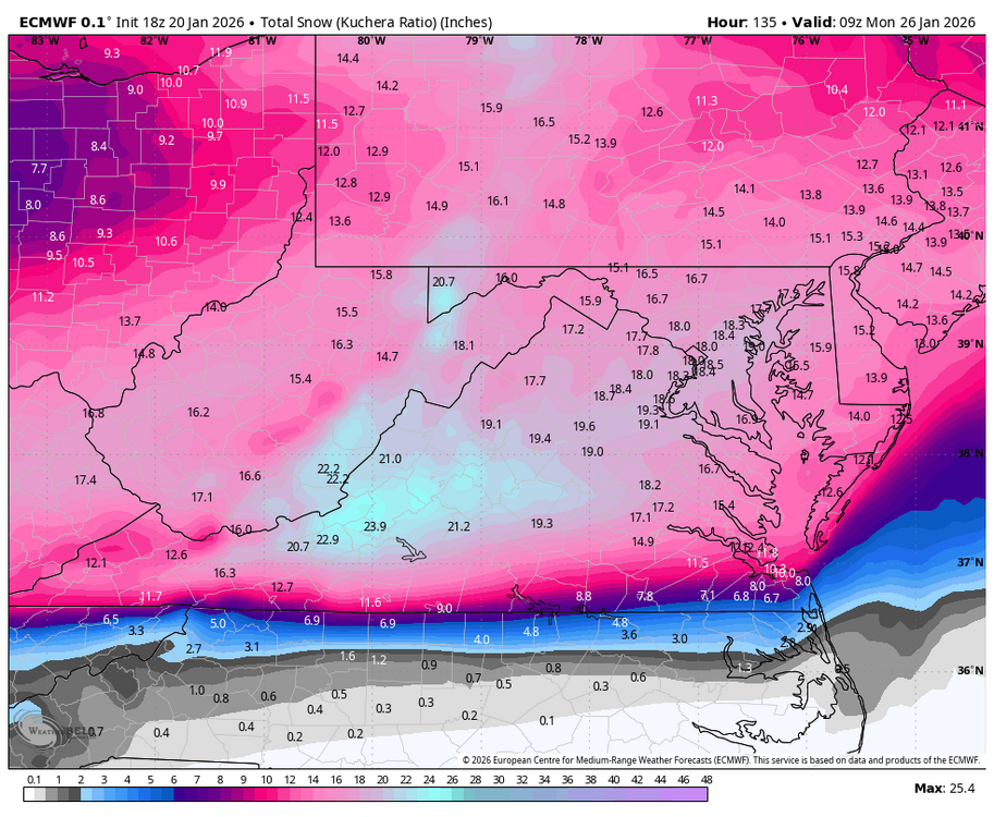
-

Possible Record Breaking Cold + Snow Sunday 1/25 - Tuesday 1/27
brooklynwx99 replied to TriPol's topic in New York City Metro
lol this is nonsense -
Just saw what you did. Thanks! In the future I'll try to post it during the off run (I guess either 5-6 or 7-10ish) but I was rushing to try to get it out before the 18z Euro messed with it (and I wanted to get food). See I'd be a lot more partial to that if I was a met otherwise I'm just another poster here. Though I suppose an argument could be made for starting a separate storm banter thread and storm mode thread in the future if it holds together.
-
Quite the jump north with the snow on the EPS.
-
Anyone have the 10:1 sleet map for GA? .
-
We’re going to get that infamous phase that’s been elusive for years and it’s going to be a mega hulk strength phase
-
22z? Extended HH!
-
I’ve been lurking long enough that I know the battle ground between ice and snow will probably be straight through wake county per usual. Climatology tells me that solution is a little overdone. But I have far from an expert. .
-
You’re looking for the Blizzard warning. I see what you did there. Wish we still had the heavy snow warning.
-
Because I’m old I can say from experience that setups like will verify with mostly snow in Winston/Gso… snow to ice to snow in CLT and about half and half in RDU with Durham of course cashing in pretty good compared to Raleigh. That’s just how these go and most of you know that. Screw the models and just enjoy a good ol’ fashioned NC winter storm!!!
-
Trough on Eps is much better than 12z and better ridging ahead on the coast. Will be better than 22z.
-
Yea I’ll absolutely crash out and sign off for a while
-
It's really not that big of a jump if you've watched the trends with the northern shortwave getting stronger and digging further SW. It's just that once it goes far enough to fully phase, the upper level warmth wins out.
-
Don't dive yet, y'all. Or at all. We are 3-4 days out. Have some good sleep and see what tomorrow brings. Hopefully not ICE!
-
I take it there were no Northern Lights sightings last night, and no chance tonight?
-

Possible Record Breaking Cold + Snow Sunday 1/25 - Tuesday 1/27
cleetussnow replied to TriPol's topic in New York City Metro
Kuchie though, and snow map 5 days out so grain of salt, salt mines worth of grains of salt. -
 I would think there is a limit on how far north this can go with that strong deporting high pressure
 -
Ya'll live and die in here with each run. There's a thread for this, please use it for your cliff diving
-
I need an alcoholic beverage.
-
Ooh ok ty bro!
-
The breakdown of warm February being predicted on the weeklies after a colder second half of January is astonishing. Obviously, good looking patterns (ie, colder anomalies and ample precipitation) don't always translate to snowstorms (such as December 2022, February 2025 etc), but this is a good look to see
-

Possible Record Breaking Cold + Snow Sunday 1/25 - Tuesday 1/27
Nibor replied to TriPol's topic in New York City Metro
At h5 we’re not too far off from some pretty big solutions. -
Is there any data available about potential wind speeds?
-

1/23/26-1/25/26 Winter Storm Thread
Holston_River_Rambler replied to AMZ8990's topic in Tennessee Valley
Even the CMC didn't get the full phase: