All Activity
- Past hour
-

Saturday, July 18, 2026 Thunderstorm/Severe Weather Potential
weatherwiz replied to weatherwiz's topic in New England
yes MCD was issued which includes western CT mentioning uncertainty in whether downstream watch will be issued -
Saturday, July 18, 2026 Thunderstorm/Severe Weather Potential
weatherwiz replied to weatherwiz's topic in New England
Expectations should always be low in our setups really. At least for me, part of the fun in all this is the "unknown". 99.999999% of the time (or some number that's essentially 100% without being 100%) severe weather here is not going to be widespread or even concentrated, its just going to be some reports scattered about and localized. But back to the fun...its the tracking and monitoring to see even if one storm produces...and if that one storm does produce, there is someone out there who was directly impacted. These setups are just so intriguing in that regard because the kinematics support the potential and generally instability is usually just enough to warrant some concern, but ultimately low enough to where maybe only a few storms will ever become mature enough to utilize the environment. -
Flash flood warning 1.54" and counting
-

E PA/NJ/DE Summer 2026 Obs/Discussion
MGorse replied to PhiEaglesfan712's topic in Philadelphia Region
A tornado warning now for portions of MD eastern shore and southern DE. -
Getting some additional rain here with continuous T&L
-
At the ducks game now. Hoping those storms fizzle or skirt south……
-
Yeah you are getting crushed again. Might end up with 5"+ over the last several days.
-
Well crap that escalated quick. Tornado Warning just to my West of the place we are staying.
-

2026 Mid-Atlantic Severe Storm General Discussion
high risk replied to Kmlwx's topic in Mid Atlantic
All of what you said is legit, but I'm leaning now towards the idea that this was an artifact. As you said, getting a strike super far away from the core is possible, but I think you need a much more powerful setup than we had today. -

E PA/NJ/DE Summer 2026 Obs/Discussion
mattinpa replied to PhiEaglesfan712's topic in Philadelphia Region
Collegeville near Wegmans was hit by heavy rain and thunder -
Looks a couple cells in west central nj moving northeast
-
That was a lie, sideways rain and T&L, torrential 1.18" now.
-
E PA/NJ/DE Summer 2026 Obs/Discussion
MGorse replied to PhiEaglesfan712's topic in Philadelphia Region
Looks like the tornado warnings so far have been outside of the tornado watch (within the severe thunderstorm watches). -

2026-2027 Super El Nino
Stormchaserchuck1 replied to Stormchaserchuck1's topic in Weather Forecasting and Discussion
^I think we are still "evening out" a strong 28-year period of La Nina: Per RONI, 5 of the last 6 years (20-26) have been La Nina. Per RONI, 7 of the last 10 years (16-26) have been La Nina. Per RONI, 11 of the last 19 years (07-26) have been La Nina. Per RONI, 15 of the last 28 years (98-26) have been La Nina. That's >50% La Nina since 1998. Since 1948, the tendency for reversal of multi-year ENSO patterns has been really strong. Here's the closest multi-year example: Only other period on record to have 5/6 La Nina's, until 2020-2026 (ONI):70-71: Moderate La Nina71-72: Weak La Nina72-73: Super El Nino73-74: Strong La Nina74-75: Weak La Nina75-76: Strong La NinaENSO tends to even out, historically. Here is what followed the 70-76 streak (ONI):76-77: Moderate El Nino77-78: Moderate El Nino78-79: Neutral79-80: Weak El Nino80-81: Neutral81-82: Neutral82-83: Super El NinoReally interesting that we didn't see another La Nina for 7 years after 70-76. Then again, it has also been really hard to go ENSO Neutral in any year: Since 1994, only 7/31 ENSO years have been Neutral, per RONI. 24/31 have either been La Nina or El Nino. Since 1994, only 7/31 ENSO years have been Neutral, per ONI. 24/31 have either been La Nina or El Nino. I don't know that we'll see a Moderate-Strong La Nina snap back this time. Cold water is not really building in the western-subsurface. Weak Nina would be my guess but I could be wrong! -

E PA/NJ/DE Summer 2026 Obs/Discussion
Chadzachadam replied to PhiEaglesfan712's topic in Philadelphia Region
Happy to miss the severe so far, any risk of the smoke sticking around if the rain busts though? -

E PA/NJ/DE Summer 2026 Obs/Discussion
BBasile replied to PhiEaglesfan712's topic in Philadelphia Region
0.06" on the day. Still 81F with a 77F dew. HRRR is not optimistic for later on. No rotation... At all? -
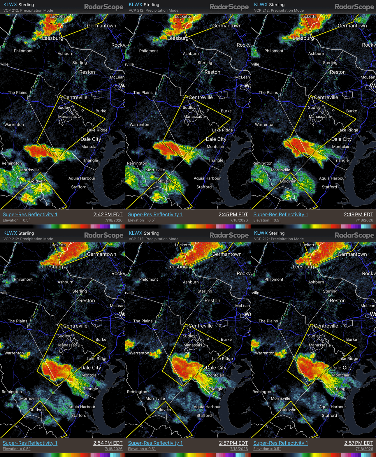
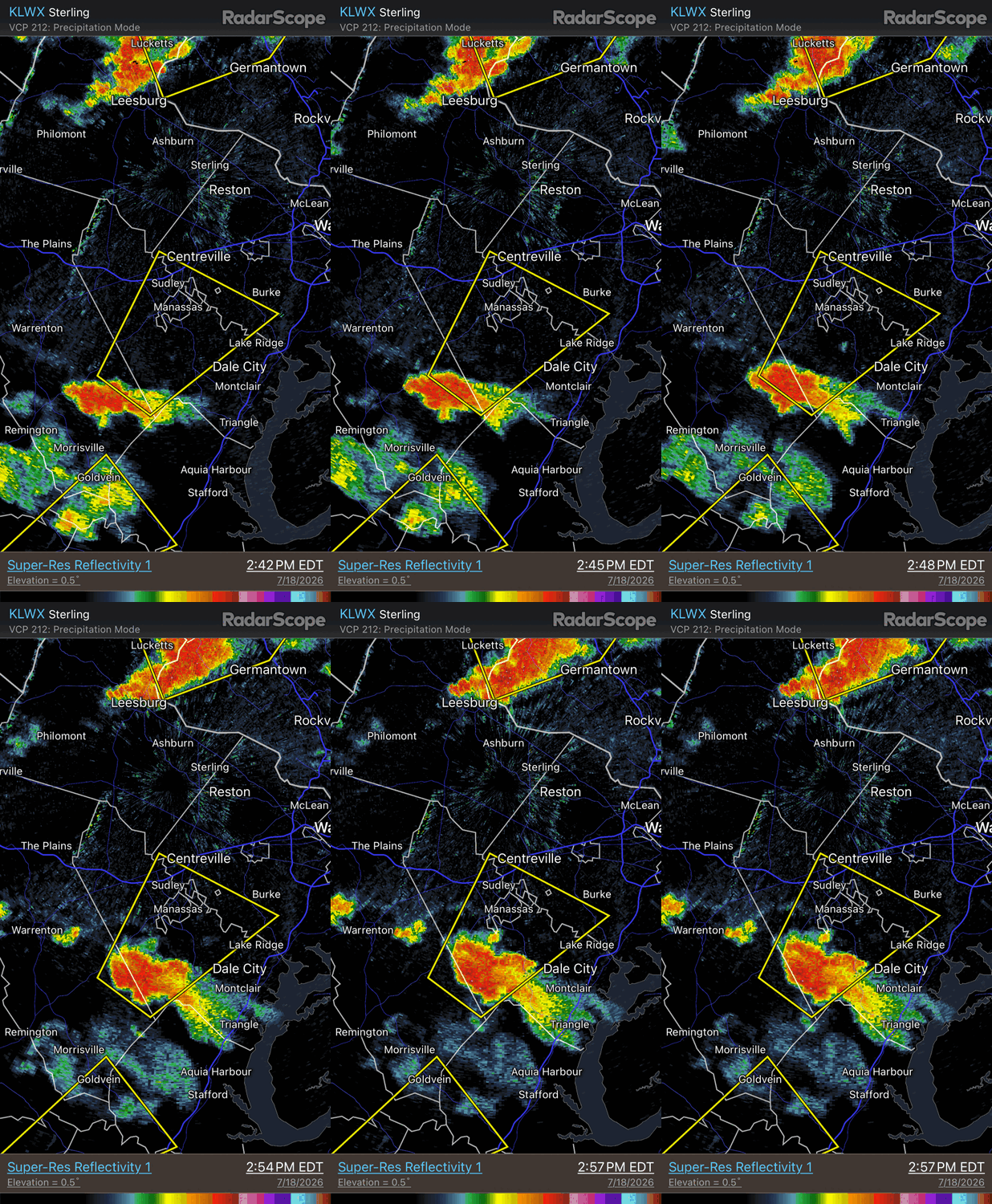
You had this left mover (anticyclonic supercell) near Manassas earlier. You do not even have to look at the velocity to know this. The storm is deviating to the left of the mean flow and it has the flared NW to SE structure w/ the anvil streaming to the SE despite the storm moving NE! When storms rotate, it becomes complex as to the total motion vectors acting on the storm. Anticyclonic supercells rarely produce tors (in the NHEMI), but giant hail and microbursts are just as likely as w/ cyclonic supercells
-

Saturday, July 18, 2026 Thunderstorm/Severe Weather Potential
Damage In Tolland replied to weatherwiz's topic in New England
We did ? -
Saturday, July 18, 2026 Thunderstorm/Severe Weather Potential
ct_yankee replied to weatherwiz's topic in New England
Unimpressed with everything about this day, had zero expectations. It was always going to be a slopfest, there was only ever one run of one model that looked really interesting for my area, and obviously that ain't enough to get exited about, unless maybe if you're Wiz (just kidding). I did raise an eyebrow when the SPC expanded probs for spinners here but never really bought into that because experience has taught me they seldom do great with New England setups and I just didn't see anything that looked unusually good for tors and supes this far north and east, despite the decent shear. Could still get surprised, I suppose, but I consider that possibility increasingly unlikely. Maybe the next one, sigh... -
0.47”. I’ll take it, but we desperately need a region-wide soaker.
-

Saturday, July 18, 2026 Thunderstorm/Severe Weather Potential
SouthCoastMA replied to weatherwiz's topic in New England
congrats MVY, awt .05" -

Central PA Summer 2026 Discussion/Obs Thread
canderson replied to Voyager's topic in Upstate New York/Pennsylvania
Originally late afternoon. But it appears any low-level shear is gone and cape never built with our socked-in cloud cover and smoke. It might storm later but I don’t personal see fuel in the HBG metro. -

2026-2027 Super El Nino
jaxjagman replied to Stormchaserchuck1's topic in Weather Forecasting and Discussion
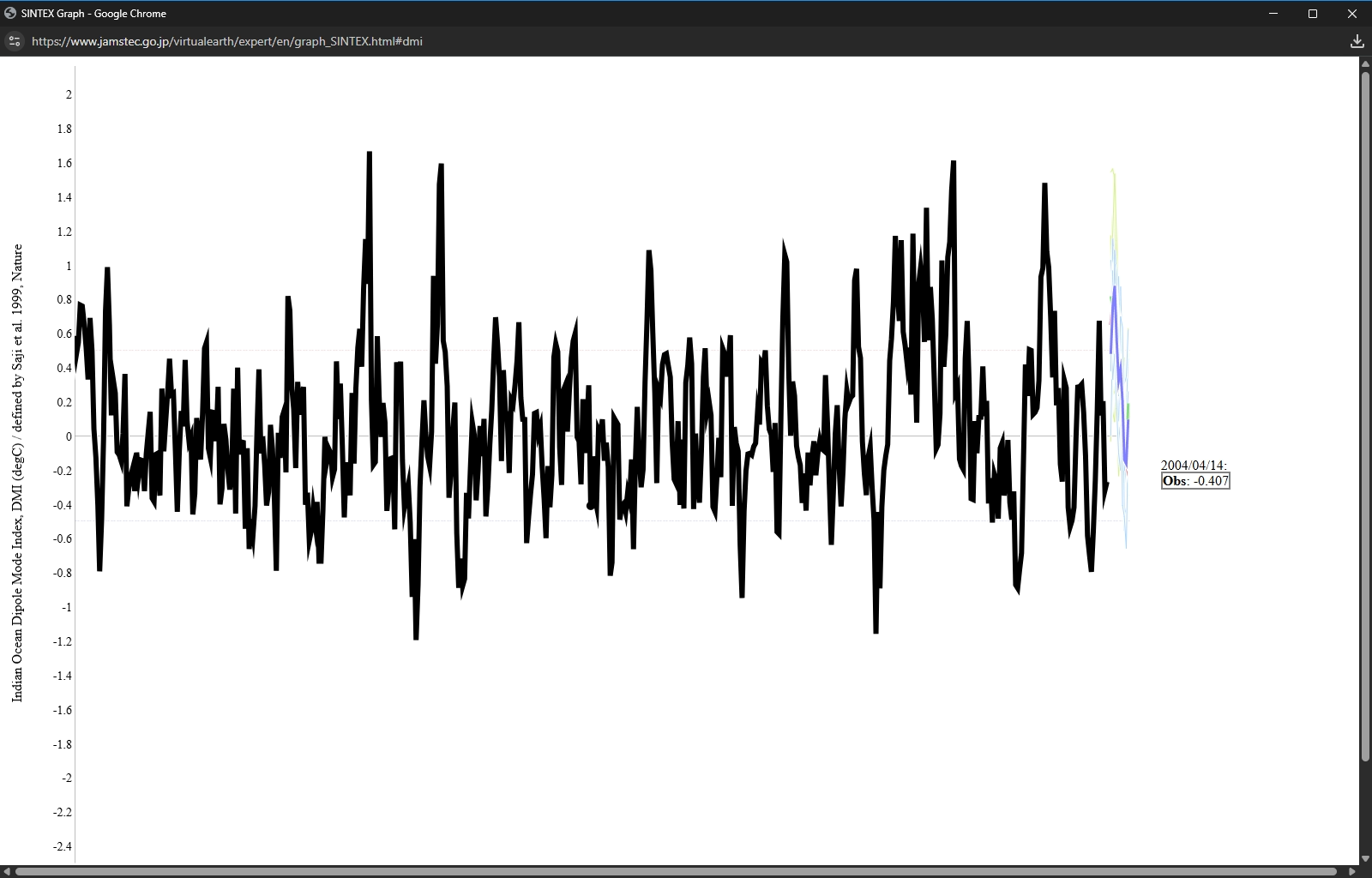
Since the early 1980's when the DMI hits a certain porportion its always followed by a LaNina the following winter.As if this is one of those years is unknown ATM.DMI peaks into fall so there is a few months to even seemingly have an idea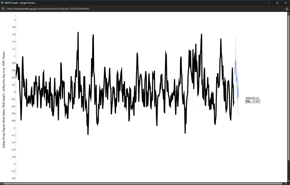
-

2026 Mid-Atlantic Severe Storm General Discussion
ThePhotoGuy replied to Kmlwx's topic in Mid Atlantic
Extensive damage throughout my neighborhood. Over 20 separate homes with trees laying on them. Trees down everywhere. Telephone poles snapped in half. Neighbors keep saying a tornado went through the area. Luckily no damage at the house but no power.- 1,152 replies
-
- 1
-

-
- severe
- thunderstorms
- (and 7 more)
-
Missed the worst of the T&L but got the rain, 0.72" and counting