ct_yankee
-
Posts
407 -
Joined
-
Last visited
About ct_yankee

-
Looks like the southern cells threw out an outflow boundary ahead of them, which would tend to curb the tornado threat as the storms are now outflow dominant.
-
Tor warning now for Worcester.
-
There's better CAPE to the south, I think those cells are finally reaching the sun warmed areas.
-
Unfortunately I was unable to chase today, but I will certainly go after anything that approaches my area in coastal CT. Not that much is expected down here but man do those hodos look spicy for the Northeast. I went to the store about an hour ago and walking to my car it was windy and cool, didn't feel at all like a severe day. OK, I get it, lapse rates are gonna suck as they always do, and low cape was progged... But when I came out of the store 45 minutes later the sun was beating down and it was hot and humid, suddenly it felt like severe was back on the table even to the coast. Still doubt anything gets near me, but anything even remotely isolated that goes up in this kind of shear is gonna spin, and yeah even the line will have embedded spinups. Don't think I've ever seen hodos this good in a warm season setup in the Northeast, ever. That definitely gets my attention.
-
They consider a TDS to be confirmation these days. At least I've seen the 'confirmed' language many times with just a TDS.
-
It was a pretty consistent TDS on radar CC. Not sure they had ground confirmation.
-
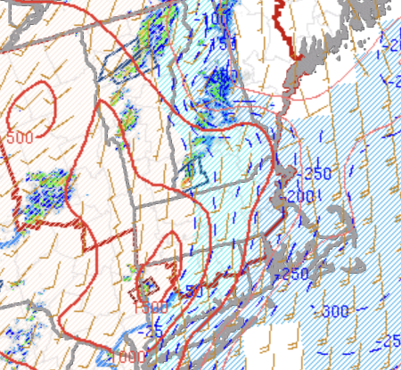
Hmm, haven't delved deeply into this yet but at first glance it looks to me like the good shear will be almost entirely gone by the time the main round of storms rolls through SNE around 18 to 21z. So timing issues for sure. On the other hand, that shear will be present for the much earlier round of convection late tonight/early morning Sunday, so maybe a surprise supercell is not out of the question then, although instability will be lacking and convection probably elevated. Midlevel lapse rates look to be a bit better earlier as well. But as usual with these setups in SNE things will change right up until the event, so I will monitor trends and see. One big plus for chasing is simply that it's Sunday. Sunday is pretty much the only day when genuine chasing in SNE is even remotely feasible, so there's that. We will see.
-
Unbelievably, I can't seem to transfer any chase pics from my newish Moto Stylus G5 phone to my newish high-end laptop computer. It used to be so easy with my old setup. Now I'm forced to use some Microsoft garbage utility that simply tells me it can't transfer files, for reasons unknown. And I can't load the pics directly from my phone to the forum because they take up too much memory, I need to downsize the file first, which I only know how to do from my computer. So no pics from me for the moment. Can't frickin believe I can't do a simple file transfer...
-
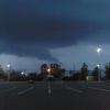
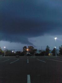
Just got back from a very successful little chase, managed to intercept 2 supercells in a short amount of time. First I watched the Poughkeepsie to Hartford cell from somewhere near Rocky Hill. The storm was tornado warned at the time and looked gorgeous! I had a clear view of the updraft base - for once no precip there - and although I didn't see a lot of rotation in the wall cloud it had really nice structure, a classic New England supercell in every way. Will try to post a pic shortly. Then on the way back I got a quick look at the southern storm as I was nearing New Haven. That cell was already outflow dominant, and it practically withered away under my gaze due to the malign marine influence that we all know and love so well here beside the Sound... But the trip was totally worth it, the Hartford cell was the best I've seen in years. Glad I stuck around (mostly), I don't think I could have done any better by going way north.
-
Mesoscale analysis shows only the northwest corner of CT is free from MLCIN. That storm should survive at least until it outruns the good air, and possibly even after.
-
Dutchess county likes to produce. Seen it many times.
-
As of right now that cell looking like it stands a good chance of becoming the best storm of the day.
-
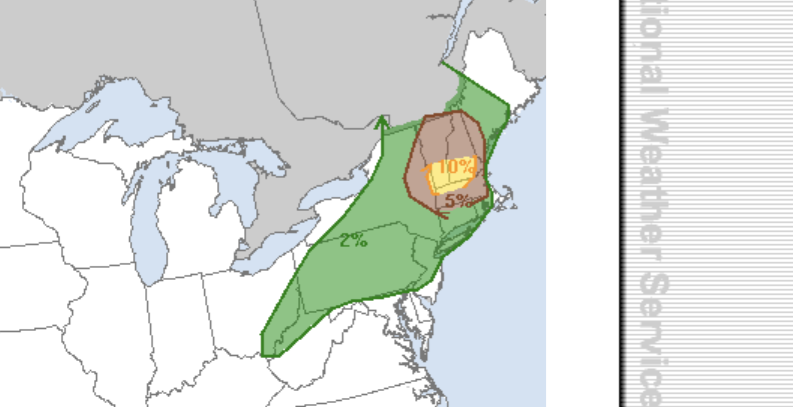
SPC truncated their 10% area, now only southern VT/NH.
-
Looking kinda messy up in VT already. Both the Rap and HRRR seem to want to bring strong convection through the Northern half of CT in the 5 to 7pm time frame. Could definitely get interesting. Feeling a bit better about my decision to stay close to home today.
-
CAMs all say central VT (and some of central NH) is the sweet spot today, just a bit too far N for me - although I would certainly travel that distance if the terrain were flat and chaseable, but it just ain't. So probably will monitor trends and only go out if something really interesting develops closer to here in far SNE, which is not looking likely. It's especially annoying as I am going to be spending a few days starting on Tuesday right in the bullseye in central VT, but you can't choose the timing of a severe day. Good luck to Wiz and anyone else actually chasing.