All Activity
- Past hour
-
-

MO/KS/AR/OK 2025-2026 Winter Discussion
NWAflizzard replied to stormdragonwx's topic in Central/Western States
Cold air stalls out west on the 18z GFS and doesn’t make its way east. Huge difference in temperature across Kansas.
-
Yep, on the 18th NWS called for a 55 high here. Stuck in the upper 30's all day, high was 41.5 at midnight and then locked between 40-41 overnight until 7 am.
-
Well the -NAO locks in the cold and this has been the biggest issue with the Pacific Jet ripping across the country and a flat high south and southeast. I see more of the same from last year with hints here and there that it could possibly change but zero is locking in.
-

November 2025 general discussions and probable topic derailings ...
WinterWolf replied to Typhoon Tip's topic in New England
I’m no math guy, but isn’t the range the difference between the two numbers of 17 and -4? Or am I misunderstanding? -
Yep no evidence that this pattern since about feb 2022 will let up any time soon.
-
Hmmm....

-
Looking more like a reflective event at this point in time.
-
There hasn’t even been one 3+ day long Dec MJO phase 8 since 2017 and the one before that was way back in 2009! So, if the models are right with their 3++ day long phase 8, it would the first time in 8 years and only the 2nd time in 15 years! A whopping nearly 80% of 3+ day long Dec phase 8 periods averaged colder than normal at Raleigh though with lots of variation. When amplitude is <1.5, that rises even further to 85% along with an average of 5.2 F BN. If it’s a pretty strong amplitude (1.5+), it actually averaged only 0.5 F BN at Raleigh. At Baltimore, it’s pretty similar for Dec phase 8 with 4.8 F BN for amp <1.5 but only 0.3 F BN for amp >1.5. Fortunately, most Dec phase 8 are <1.5 amp.
-
I drove up and hiked to the summit this AM. Funny, there was a dusting of real snow that was protected from the sun. They made snow today until about 930ish. Went into the lodge afterwards and tried to purchase my uphill pass but it's not for sale yet.
-

-
The big ten has won the last two national championships
-
How about models being off 10 degrees for thermal highs in 12 hours. Is that acceptable???
-

2025-2026 ENSO
BuffaloWeather replied to 40/70 Benchmark's topic in Weather Forecasting and Discussion
Put out today
-

November 2025 general discussions and probable topic derailings ...
kdxken replied to Typhoon Tip's topic in New England
-
But we dont know whats going to be realistic or not. We haven't seen a SSW this early in a long time.
-

November 2025 general discussions and probable topic derailings ...
Typhoon Tip replied to Typhoon Tip's topic in New England
Shhhhh My internal monologue sarcastically said something similar when I saw that run... But it looked less coherent with the EPO aspects... it's like it dropped below the threshold ( probably in error by doing so - ) where it's no longer forcing down stream over the continent by being too weak. That's why it has semblances of the NE Pac mode but dwindles. Goes without saying .. we don't sweat it beyond D7. -
Hard to feel good about the trade off imby coming off a 14.1" snow season (RFD).
-

December 2025 Short/Medium Range Forecast Thread
BooneWX replied to John1122's topic in Tennessee Valley
Good stuff everyone. I always learn something from a visit to this region of the forum. -

Central PA Fall Discussions and Obs
Jns2183 replied to ChescoWx's topic in Upstate New York/Pennsylvania
From the video i have seen the lightning was mind-blowing. They also spoke about a possible microburst. Sent from my SM-G970U1 using Tapatalk -
It’s better to be realistic about the model errors beyond 10 to 15 days and the frequent repeating patterns. I get it that many on here like cold and snowy weather. But you want to see the cutter, hugger, and suppressed Southern Stream storm tracks shift in order to be more optimistic about our snowfall prospects.
-
The eff you mean “getting” dude you been here damn near 25 years youre old.
-
The first week of December was never on the table
-
Weather models have improved a lot in 20 years. We have data to prove it.
-
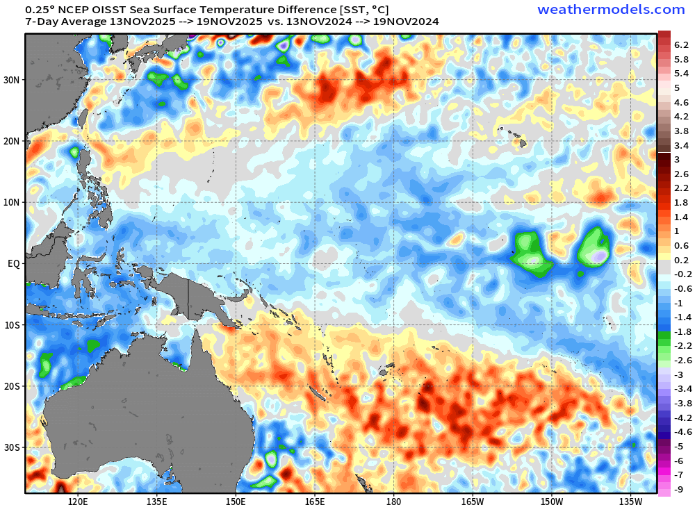
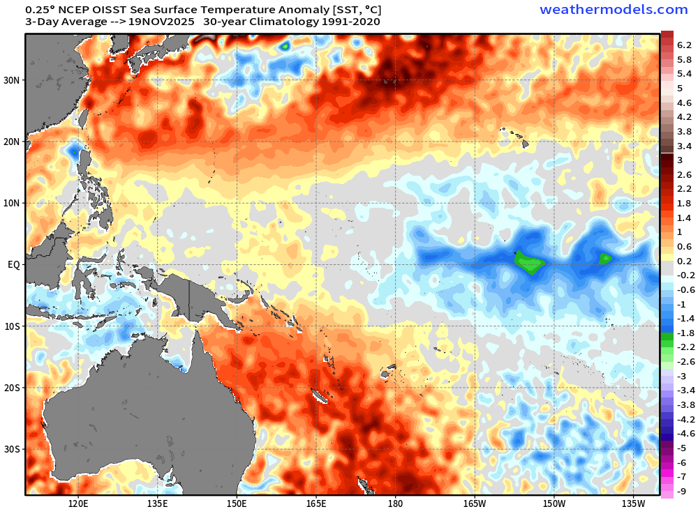
Fair enough. However, the example you were using was displaying basically the textbook la nina phase 7 response. We'll see how it goes. Another thing for consideration. The waters in that area of the globe have cooled significantly since last year. First image below is the difference between now vs 1 year ago. Enough so, that it's mostly near normal now in the equatorial band (10N-10S). With a non insignificant area having below normal temps even for a change (2nd image). A sight for sore eyes. So perhaps that factor can be muted this time.