All Activity
- Past hour
-
That is how I am rolling as well. Time of day does not help us with the first system.
-
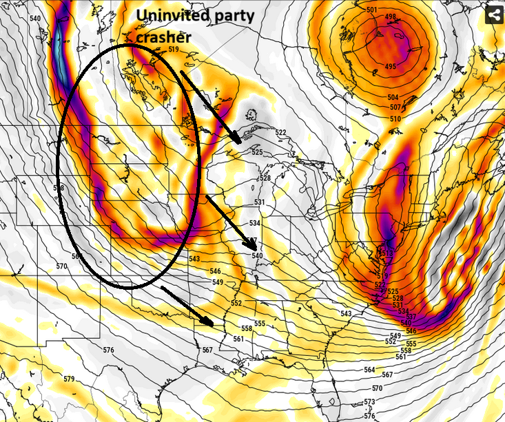
Plenty to like. Starting with the 500 mb pattern. Confluence to the north and height lines oriented SW to NE, with a flattened SE ridge. Great look for the MA and folks in the SE should pay attention too. Add the +Precip anomalies from mid south-Tennesse Valley into into the MA, and colder than avg temps. I didn't even look at snow maps(no need to) when I made my earlier post about this period. Potential is there, we just need an event or 2 to actually materialize.
-
Schtick.
-
We’re a superstitious bunch.
-
Some of us know what a sensitivity analysis is. And for those who do not, your link is helpful. But what you present is not a sensitivity analysis. Or maybe you are withholding most of it, which should include: - which inputs you used in your analysis - how they were perturbed - how the output (mean temp) varied with those perturbations - ranking of influential variables The goal of a sensitivity analysis in to determine which variables have the biggest impact on some output... not just what is the most likely output. And if the variables, assumptions, and their tested ranges aren't included, the output is kind of meaningless.
-
We'll reach the half-way point of winter out here with 1" of snow. 1". And in a winter that has averaged BN temps. And on the heels of 9 consecutive BN snow winters.
-
I should unpin it to let the weather gods know it was a mistake and they will take pity on us and give us snow. Once i do that it will be in ma natures hands and hers are as good as AJ Browns were yesterday.
-
Great synopsis. Thanks.Yes I was pumped to see the 5H CLOSED off of us. Whatever made modeling move 300 miles ???
-
Stein ,, nothing like a Steiner pattern in the heart of winter
-
please explain Ji. He hasn't gotten 'there' yet in 15+ years
-
Here's the 132 hour cumulative total of ICON QPF ... LOL wow. this is awesome...
-
Horrible game. Can't even win a snowstorm either!
-

Winter 2025-26 Medium/Long Range Discussion
A-L-E-K replied to michsnowfreak's topic in Lakes/Ohio Valley
unsurprisingly, LES threat dead on this side of the lake and for better or worse, thurs/fri duster probably going to be one of the better winter weather events of the month -
@metagraphica do you know exactly what you got on 1/28-29/22 blizzard?
-
I agree strongly with everything written except this. I believe these features are not causally connected. They are only loosely correlated, and always in hindsight. Besides that, the trof IS clearly sufficiently sharp for a major event. But the synoptic details (which you correctly mention) impede development in a way that would impact us locally.
-
ICON wants nothing to do with the 18th threat. As unlikely as it seemed a few days ago, we might have to punt most of January. I remember all the talk about winter cancel and winter over in January 2021 after that month was dry and mild. Similarly, there was evidence of a big pattern change and a shift to colder and stormier across the US by end of January and would last through February. That panned out very well, and it saved winter. But years like 2021, 2013, 2006, 2015 are few and far between. If the 18th doesn't work out either, it's quite possible that winter has shown its cards and it'll be time to pack up. Long range Euro and GFS looks great with ample cold and chances for snow through early Feb and it doesn't seem to be losing the pattern change either. But who's to say the rest of the chances for snow won't go the way the 16th and 18th went?
-

Winter cancelled/uncancelled banter 25/26
NorthShoreWx replied to Rjay's topic in New York City Metro
Do you feel better now? -
Yeah, the teleconnection indices are becoming more favorable for us in that time frame than they are this week.
-

Central PA Winter 25/26 Discussion and Obs
Mount Joy Snowman replied to MAG5035's topic in Upstate New York/Pennsylvania
Low of 26 with a trace of snowfall. Also, I had .45" from Saturday's rain. I've been a bit out of the loop but it seems the potential for a big hit late this week has diminished. Always more ways to make an out than get on base. Oh well, I still think we'll see several periods with flakes in the air and the cold looks to stay mostly entrenched. That's good enough for me. Onward. -
For those who want a highly simplified but easy-to-understand description of sensitivity analysis, one can reference the following: https://thedecisionlab.com/reference-guide/statistics/sensitivity-analysis. And for those who want insight into the estimated probability, applying multiple variations to the model value, assessing the probability against a benchmark (1991-2020 normal value) using a normal distribution.
-
I'm not too enthused with the upcoming wave on Wednesday night/Thursday morning for Knox county. We might see some flurries/light snow, but I doubt we will get anything more than a dusting. Hopefully NE TN gets a little more from it. The weekend system could be interesting because of the potential for high ratio snows with how cold the models are showing, but we still have a ways to go for that system.
-
Don, if you go with uncertainty analysis or probabilistic analysis, then I think we're on the same page. But not sensitivity analysis. Early in most months it should be close to a coin flip whether the month will end up above or below normal. Our climatic base state relative to previous decades is warm, so we hedge warm to start. And then Bayesian updating based on long-range modeling.
-
Of course not... but this isn't about the virtuous journey in pursuit of objective understanding in here. You kidding? You're dealing with weather drama -related dopa addicts LOL The dealer got arrested and didn't make the scene - so now your attempting to explain things to the open-mindedness of withdraw rage. Hey, more power to ya -
-
Yeah, It would be cool if we knew how many hr 384 KU's that the GFS use to have that actually worked out.
-
Wild guess here but, I'm betting few or no one is going to be interested in this. I'm actually curious at this point if we can hop-scotch our way through this +d(PNA) without getting anything at all like these ICON's and GGEM ideas. This thing has been plagued by this the whole way. As a snap observation, it seems even in +PNAs the fast nature of the circulation foot is crowding and not letting kinematics be conserved at small scales (cyclone) in lieu of the frenzy in the hemisphere...