All Activity
- Past hour
-
storm reports and warning boxes today
-

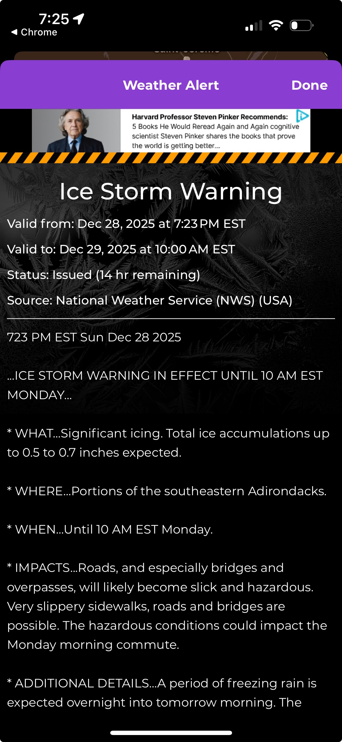
Ice Ice Baby December 28-29 Storm Discussion
dryslot replied to Baroclinic Zone's topic in New England
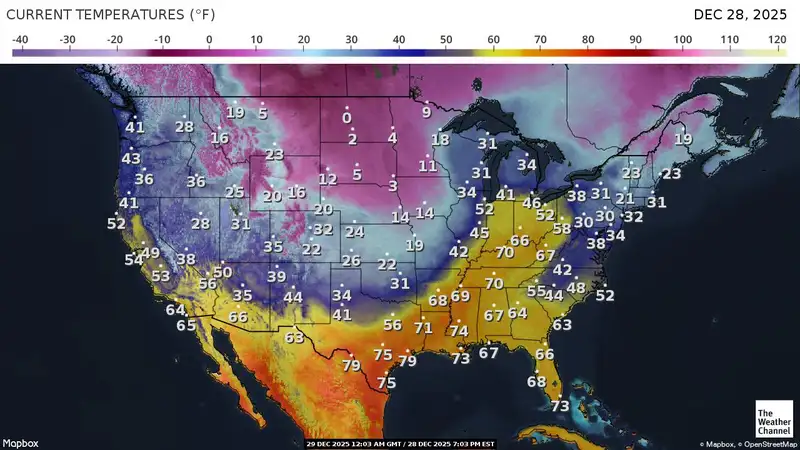
19/18F -
Felt

-
Bomb fuel:
-
Tomer is a f’ing weenie.
-
lol from the top shelf
-
When we have lost Mitch and Will we’re F***ED.
-

2025-2026 Fall/Winter Mountain Thread
Carvers Gap replied to Buckethead's topic in Southeastern States
Met, how does that scoring system work? Blues, reds, yellow, points? -
tornado debris signature was near Clifton IL at 3:48 Central
-
AI GFS with a big winter storm on the 10-11th
-
Fixed it for ya
-
lol that call by the Bills was basically "it's f*cking miserable out here, let's go home"
-

E PA/NJ/DE Winter 2025-26 Obs/Discussion
MJO812 replied to LVblizzard's topic in Philadelphia Region
Hope we all cash in big time soon. Nice Miller A. -
630 updated BTV discussion https://forecast.weather.gov/product.php?site=BTV&issuedby=BTV&product=AFD&format=CI&version=1&glossary=1 As of 632 PM EST Sunday...Radar showing freezing rain expanding quickly toward our cwa this evening with precip expected to develop in the next 1 to 2 hours. Water vapor shows impressive rapidly developing cyclone over the central Plains, with potent s/w energy/dynamics helping to enhance thunderstorm development in the Ohio Valley. In addition, strong-deep layer moisture and thermal advection continues from the northern Ohio Valley into central NY, as precip continues to expand in areal coverage. Upstream 3 to 4 hour qpf amounts at BUF are impressive with >0.75" occurring, its this heavy axis of precip with elevated instability that will move acrs our cwa later tonight into Monday morning. I have bumped up qpf amounts to match upstream trends and latest CAM output. Given crnt temps in the upper teens to mid 20s, most precip starts as freezing rain, but a switch occurs first along portions of the northern Dacks and central/southern CPV, associated with downslope warming. Elsewhere, cold air and freezing rain lingers the longest over the SLV and east of the Greens, including the CT River Valley. Still thinking ice accumulations of 0.15" to 0.30" in the advisory and 0.50" to 0.75" in the ice storm warning looks reasonable, given latest 21z HRRR and RAP data. Just minor tweaks made in grids attm. The gusty west to southwest winds on backside, especially parts of the SLV and downslope portions of the eastern Greens could produce additional power outages on Monday night into Tuesday. Travel will be extremely difficult late this evening and especially during the Monday morning commute.
-
Yep right now
-

Ice Ice Baby December 28-29 Storm Discussion
qg_omega replied to Baroclinic Zone's topic in New England
Just went ice storm warning but luckily everyone here said this is not an ice storm setup
-
I am battling the Flu today. Been absolutely awful. Just ignore my attempt at humor. Didnt mean anything by it.
-
In the 98 icestorm, the cold was at low levels west of the Greens but here in the east the ice was at 1000"+. It was very odd to me at the time.
-
DTW was 43 at 6pm and 57 at 7pm
-

Central PA Winter 25/26 Discussion and Obs
Jns2183 replied to MAG5035's topic in Upstate New York/Pennsylvania
Anyone have good historical data for the Greenland blocking index (GBI), the Atlantic Ridge index (AR), Polar Cap Height (PCH)? I think with those values I could have some real fun in my data analysis project for this area. I already have the 4 big teleconnection index values daily going back to 1950. Daily weather records for the the complete history of almost every station that had reported at one time or another in about a 6 county area around South Central Pennsylvania Sent from my SM-S731U using Tapatalk -
as I said those must have been some times,,,,
-

Ice Ice Baby December 28-29 Storm Discussion
AstronomyEnjoyer replied to Baroclinic Zone's topic in New England
25.7°/21.3° Will be interesting to see how well ice accretes here at 900ft vs. 1400ft just up the road. Thankfully, it doesn't look like it'll accrete too well on branches for the most part. Either way, I'm expecting the ground to resemble a glacier by tomorrow afternoon. Might need to bust out the damn ice skates to navigate the yard. -
I remember seeing ice flowing under the Verrazano and in that bay many times as I grew up in Brooklyn and that happened often in the 70's and 80's,,,,,
-
Wait, is DE part of the forum?
-
No freezing rain ever. There's nothing worse. Whoever wishes for it. Never actually lived through an ice storm.