All Activity
- Past hour
-

Central PA Winter 25/26 Discussion and Obs
pasnownut replied to MAG5035's topic in Upstate New York/Pennsylvania
Overnighters look to have flattened the flow, which makes more sense to me. While nao and ao are on the rise,both still in - territory next week. Add to it - pna, a flatter look seems reasonable. Beyond that...dunno, but next week still doesnt look bigly warm to me. Every week we add to this awesome stretch is fine by me. Spring will be springin soon enough and it'll make the warmth feel gooder. Headed north in a few hours. Have a great weekend all. Bundle up and enjoy the snow. -
The last 2 days I’ve been in the areas where the ice storm was most severe. It will take months to clean up all the trees & power poles. It’s much worse than the 94 ice storm. Many roads are 1 lane still from trees down everywhere. The ground being beyond saturated is also making it very difficult to get into areas to remove debris & trees.
-
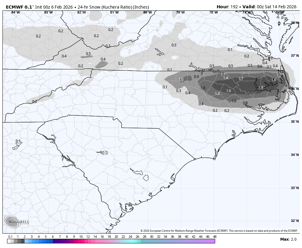
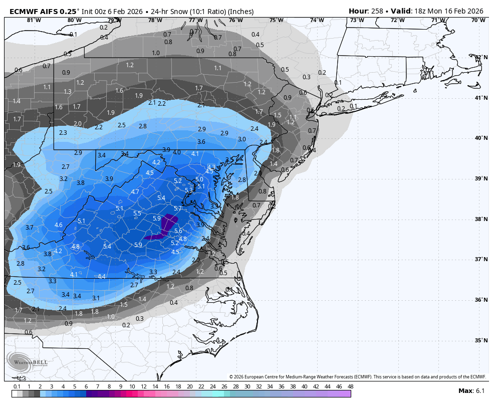
0Z Euro: nice snow NE NC AM of Feb 13th:
-
 That’s not going to happen…but if it did, mid Feb, with a cold N Amer profile, a block and 50/50, and a perfect track rainstorm…I have the final chapter of my book
 -
That reminds me, I should take some more shots of the Clinch before the warm up. It will be the most iced I have seen it since Feb 2015 (that's what got me first lurking on amwx) where in select portions it wholly froze over at the bends. Maybe some good shot opportunities on Lake Witten or Hayters Gap too if they've been plowed. I'd try Hidden Valley or Laurel Bed but that's probably an insurance premium nuke if I've seen one haha.
-

2025-2026 ENSO
so_whats_happening replied to 40/70 Benchmark's topic in Weather Forecasting and Discussion
Unfortunately those 10 or so days were not all that fun for here. Eastern NC though I'm sure was just in love with this pattern lol. From the looks of the Nina phase 1 passage is taking place this weekend. Large cold dump with warming through much of the plains showing up. Going forward it does show cold building back up into Canada to be unleashed again at some point maybe the last week or so of February into early March as we move into Phase 2/3?

- Today
-

February 2026 Medium/ Long Range Discussion: 150K Salary Needed to Post
bncho replied to Weather Will's topic in Mid Atlantic
Euro AI has some PD action
-
Yes,its been like that for whatever reasons North of 1-40 seemingly the last couple decades,its the battle ground and we 90% of the time,lose
-
 Canadians got a storm [emoji1063] .
 -

Richmond Metro/Hampton Roads Area Discussion
TampaMan replied to RIC Airport's topic in Mid Atlantic
Y'all should just start naming threads like they do.. they already do it... do it!!! -
Ar aghaidh linn! https://www.tropicaltidbits.com/analysis/models/?model=gfs®ion=neus&pkg=mslp_pcpn_frzn&runtime=2026020600&fh=138
-
 This looks ominous! Thread?
-
Sometimes the slurs backfire, like with Yankee. Although that is still kind of a slur. Let's go Mets. A ligean ar aghaidh go hÉirinn.
-
With the amount of cold we've had at times since November, this would normally have been a 35-40 inch snow winter here. So it's definitely not been as good as it could have been from a frozen precipitation stand point for most of the state. 100 miles north in Kentucky, they're probably at 40+ inches this winter.
-
Actually getting light snow tonight. Didn't expect that.
-
Been a crappie winter win here thus far for us,unless you get into ice storms. Per Nashville in Jan.1.4" SN,that was before the ice storm and then a dusting after the ZR finally ended,that was the extent to our snow this winter other than token flakes at times which didnt add up to anything Temps were 2.4 BN.Last Jan we was 6.3 BN
-

Is we back? February discussion thread
RUNNAWAYICEBERG replied to mahk_webstah's topic in New England
You know one is living the weenie dream when fluffy flakes don’t cut it anymore… -
Given how crappy the previous 4 winters have been, this winter has been outstanding. We can't always have a 1992-93, 1995-96, 2004-05, or 2014-15 every time for a "good" winter. CoastalWx mindset: "If it is not a Bliz of '13 RIPPER w/ everything but the kitchen sink falling out of the sky, I'm dissatisfied!"
-
I can’t believe the dumb ass Wizards beat the best team in the Eastern Conference tonight. I hate them.
-

Friday February 6 FROPA / WINDEX small event
vortex95 replied to HoarfrostHubb's topic in New England
It's PT time for CoastalWx! RRFS FTW! Such a slow evolution of the 500 trough over New England Sat-Sun. It just doesn't sweep though, it elongates and cuts off for some really good OES weenie bands IMHO. 500 temps drops as low as -38 C, which is about as cold as you will see them in the NEUS. -40 C at 500 in the CONUS does not happen too often, and I think the limit at 500 for temps is around -50 C (coldest I have seen in NAMR is -51 C). There is some physical atmospheric reason why it can't get colder than this I recall, but I forget the reason why.
-
Thanks
-

E PA/NJ/DE Winter 2025-26 Obs/Discussion
RedSky replied to LVblizzard's topic in Philadelphia Region
0z runs looking anemic for the frontal passage -
Active pattern coming with a few snow chances
-
Active pattern coming with a few snow chances
-
E PA/NJ/DE Winter 2025-26 Obs/Discussion
RedSky replied to LVblizzard's topic in Philadelphia Region
Sleetfest 1&2 Not enough sleet on this stuff it collapses