All Activity
- Past hour
-
Maybe 0.10” here. Predictable as the day ending in “y” that it breaks up and dissipates as it gets here.
-
Picked up 0.6” yesterday, loved the ol’ fashioned thunderstorm at night. Going with a bold prediction that this is the start of the ‘un-droughting’ of the region.
-
It rained pretty heavily several times overnight. Definitely a lot more than I expected. I'm getting one last heavy downpour as I type. Great news!
-
0z EPS looks close to mid 90s, Tues May 19.
-

2026-2027 Strong/Super El Nino
Stormchaserchuck1 replied to Stormchaserchuck1's topic in Weather Forecasting and Discussion
Nice 3 day run of -SOI 14 May 2026 1009.81 1010.30 -15.45 -5.70 -0.07 13 May 2026 1010.40 1010.50 -12.47 -5.50 0.32 12 May 2026 1011.99 1012.00 -11.78 -
2026-2027 Strong/Super El Nino
Stormchaserchuck1 replied to Stormchaserchuck1's topic in Weather Forecasting and Discussion
Where you been buddy? We miss you! Down about the MEI coming in lower? - Today
-

Central PA Spring 2026 Discussion/Obs Thread
pawatch replied to Voyager's topic in Upstate New York/Pennsylvania
What a storm last night. Radar looked impressive! Lightning was crazy , been awhile since I seen so much lightning. straight down strikes, across the sky lightning, circling lightning precipitation was sporadic. .39” to nothing less than a mile away. Currently 45 degrees edit: got up at 2:00am pbreak solid fog, got up at 5:00am no fog at all. -
0.35" Light showers moving through now. Almost 3/4" since Monday. Not bad.
-
The line of showers is once again weakening as it moves east into the metro - lets see if it ends up stalling out as some guidance suggests once it is over the metro - really need the rain.....
-
Every day its the same damn thing: overcast and temps in the 40s. Early Mays sucking is nothing new, but paired with how dark and cold this spring has been here its gross beyond measure! Even on days with sun typically it doesn't last; the clouds start rolling in at 10am then overcast by mid afternoon half the time. Last week had a bit of reprieve for sun just barely enough to keep us from going mad. Last period to have avg sunshine was in January! Weds felt like a Nov day: dark, misty in the aft, 5C/upper 30s. Morning was "warm" but it tanked.
-

E PA/NJ/DE Spring 2026 Obs/Discussion
RedSky replied to PhiEaglesfan712's topic in Philadelphia Region
.30" -
I was just noticing that... the radar estimations tonight... did not do great! Overcooked in a lot of places. Anyway... about 2/3" of an inch here. .4" of which fell in about 10 minutes.
-
Just got home from work and based on radar estimates, I’m disappointed to have .47” in the gauge.
-
I’ll have to do some research on this. I’m definitely not using RadarScope to its potential. Those are awesome shots!
-
.45 way more then I expected
-
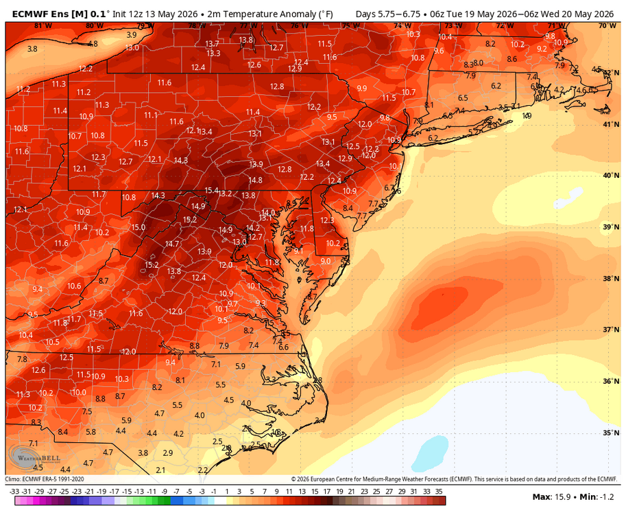
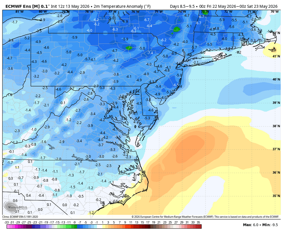
Hot early next week, but it cools down by the end of next week. Hopefully some more rain with the late week cool down. WB 12Z EPS.
-

E PA/NJ/DE Spring 2026 Obs/Discussion
KamuSnow replied to PhiEaglesfan712's topic in Philadelphia Region
Hoping to get a quarter inch at least from this, right on the doorstep. A couple lightning flashes, not much, getting breezy here now.
-
FINALLY some really good rain here over the city. Love rain at night - one of my favorite things.
-
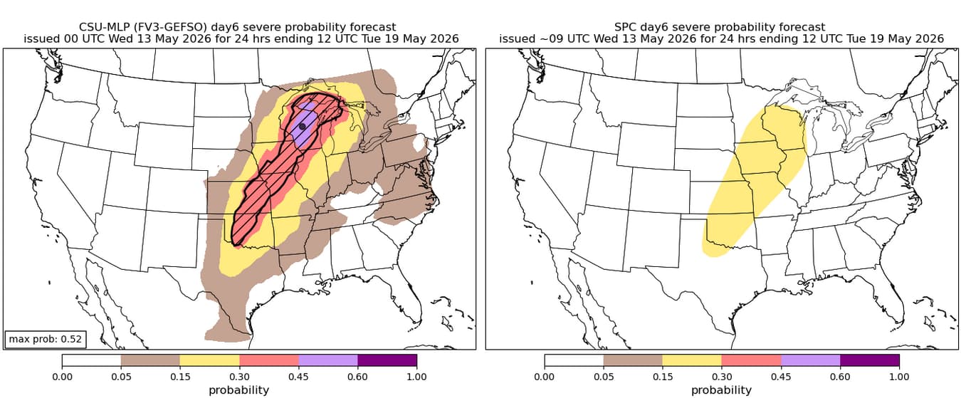
monday could be interesting, surprised to see the csu come in this hot, but multi-day svr wx possible from the plains up to the upper midwest

-
The HRDPS is the best short term model IMO. Always seems to have the best handle on convection evolution.
-
44.5° for a high so far and only 0.09” rain We’re a few days away from the timing of the 5/18/23 freeze that took out a lot of fruit trees and leaves. But the leaves and flowers are way behind where we were the .
-
I'm still mourning the loss of the DGEX... a real OG
-
E PA/NJ/DE Spring 2026 Obs/Discussion
RedSky replied to PhiEaglesfan712's topic in Philadelphia Region
Streams are running at a trickle Rained heavy for two minutes -
Some pretty lage drops still
-
the current fv3 RRFS (which afaik is the one rolling out as operational on aug 31) is not great. word on the street (twitter) is that the mpas RRFS is much better, but won't be operational for a while longer


.thumb.jpg.ad3a2e31d30aff035044689b311a0540.jpg)